

batmanbrad
-
Posts
185 -
Joined
-
Last visited
Content Type
Profiles
Blogs
Forums
American Weather
Media Demo
Store
Gallery
Posts posted by batmanbrad
-
-
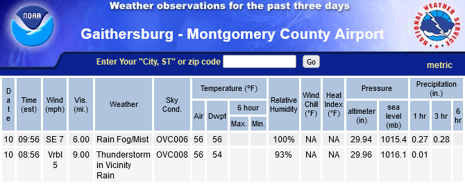
measured (primitively) nearly 5" here in Gaithersburg (close to Laytonsville), still coming down lightly for now. Does look central MoCo/HoCo has been in the sweet spot so far.
-
1 minute ago, Grothar of Herndon said:
Except Georgetown…flood watch
or even worse, SPC might include mentioning Georgetown in their convective outlook for Friday, including risk of hail the size of snowflakes?
-
 2
2
-
-
25 minutes ago, TinGTown said:
Still no flakes in Georgetown (DC) for several hours. It's now a misty rain. What are we to expect?
If you were able to post *current* pictures of the rain (and no snow) you've been experiencing the last several hours, we MIGHT believe you... but we're betting you can't/won't do that.
-
3 minutes ago, H2O said:
Now that darkness my old friend has arrived, roads have finally started to give up the fight. Like the Commanders defense
or worse (given they lost to the sorry Pistons earlier today and gave up their "usual" 130 or so points), the Wizards "defense"
-
heavy stuff just finished up here in Gaithersburg, we seem to have been in the (relative) sweet spot for QPF - between last night and today, about an inch measured at the airpark a couple of miles from me since midnight as of the 6PM obs there, added to the roughly 1/4 inch from yesterday.
-
yep, both lightningmaps and the MoCo airpark reporting station confirm the lightning earlier:
-
1 hour ago, WxUSAF said:
Pretty much equivalent to the 2nd heaviest snow of last winter
Hey, if Topeka can get more snow over this past weekend than they did all last winter (and close to their biggest November snow ever), we can certainly make a run at our total from last winter, right?
-
 1
1
-
1
-
-
5 minutes ago, Eskimo Joe said:
Almost looks like a cold conveyor belt on radar.
In the wintertime, assuming temps were cooperating, we'd be screaming PIVOT!!
-
1
-
-
with most areas close to DC seeing between 2 and 3 inches of rainfall, it would seem the models handled this overall pretty well. some yesterday were worried we would underperform on QPF, but it looks like instead of turning NE as the NHC and a few others predicted, the remnants of Ophelia pretty much stayed on a northerly track enabling the overnight rains to keep well within the I-95 corridor and points west. Despite the overall weakening trend, because the remnants were moving at a fairly slow pace, the rainfall amounts kept adding up nicely, especially for those in the worst drought areas. As of now Dulles looks like they got about 2.75" for a local airport jackpot.
-
1
-
-
coordinated with the the above-mentioned MPD by ThePhotoGuy...

Flood Watch
National Weather Service Baltimore MD/Washington DC
217 PM EDT Sat Sep 23 2023

DCZ001-MDZ011-013-014-016-504-506-VAZ053>057-527-240915-
/O.NEW.KLWX.FA.A.0012.230924T0000Z-230924T1200Z/
/00000.0.ER.000000T0000Z.000000T0000Z.000000T0000Z.OO/
District of Columbia-Southern Baltimore-Prince Georges-Anne
Arundel-Charles-Central and Southeast Montgomery-Central and
Southeast Howard-Fairfax-Arlington/Falls Church/Alexandria-
Stafford-Spotsylvania-King George-Central and Southeast Prince
William/Manassas/Manassas Park-
Including the cities of Washington, Baltimore, Bowie,
Suitland-Silver Hill, Clinton, College Park, Greenbelt, Laurel,
Camp Springs, Glen Burnie, Annapolis, Severn, South Gate, Severna
Park, Arnold, Odenton, St. Charles, Waldorf, Bethesda, Rockville,
Gaithersburg, Silver Spring, Columbia, Ellicott City, Reston,
Herndon, Annandale, Centreville, Chantilly, McLean, Franconia,
Arlington, Alexandria, Falls Church, Falmouth, Fredericksburg,
Dahlgren, Dale City, Manassas, Woodbridge, Lake Ridge, and
Montclair
217 PM EDT Sat Sep 23 2023

...FLOOD WATCH IN EFFECT FROM 8 PM EDT THIS EVENING THROUGH SUNDAY
MORNING...

* WHAT...Flash flooding in urban areas caused by excessive rainfall
  is possible.

* WHERE...District of Columbia. Portions of Maryland, including the
  following areas, Anne Arundel, Central and Southeast Howard,
  Central and Southeast Montgomery, Charles, Prince Georges and
  Southern Baltimore. Portions of Virginia, including the following
  areas, Arlington/Falls Church/Alexandria, Central and Southeast
  Prince William/Manassas/Manassas Park, Fairfax, King George,
  Spotsylvania and Stafford.

* WHEN...From 8 PM EDT this evening through Sunday morning.

* IMPACTS...Excessive runoff may result in flooding of rivers,
  creeks, streams, and other low-lying and flood-prone locations.
  Flooding may occur in poor drainage and urban areas.

* ADDITIONAL DETAILS...
  - As the center of Tropical Storm Ophelia moves north along or
    near the Interstate 95 corridor, it will produce an area of
    enhanced rainfall. This is expected to result in 2 to 3
    inches of rain, with high end amounts of 4 inches possible.
    This heavy rainfall will occur in a 1 to 2 hour period, and
    could result in flash flooding within the urban I-95
    corridor.
  - Please visit www.weather.gov/safety/flood for flood safety
    and preparedness information

PRECAUTIONARY/PREPAREDNESS ACTIONS...

You should monitor later forecasts and be prepared to take action
should Flash Flood Warnings be issued.

&&

$$

KR
-
1
-
-
also looks like the 12Z GFS is (so far) west of 6Z, at least through 30.
-
1
-
-
35 minutes ago, H2O said:
It will be right in winter when it shows no snow
or alternatively, it WILL predict snow, we willl get sucked in (again) and trust it, but it will be... wrong again.
-
1
-
-
looks like the 00z Euro came a fair amount west (and sped up somewhat as well), give most of our area at least 2" QPF.
-
NWS thinking highly enough of the repeating storm possibilities to hoist a flood watch for parts of our area. Must think there could be a lot of heavy rain considering the fairly dry antecedent conditions.
-
wondering how well that mass of stuff approaching Fredericksburg will hold together, if it does and with storm motion mostly south to north today, could get quite a dumping unless the storms around DC now stabilize things before the southern mass can get here.
-
definitely looks like some boundaries are colliding in central MoCo. I'm here close to Laytonsville, skies just opened up and have some pretty solid wind gusts so far.
-
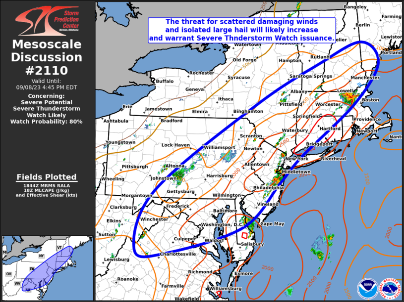
MD is out, watch likely:
-
2 hours ago, WxUSAF said:
Come on storms! Need more to the east!
some stuff trying to get going in the Chantilly and Fair Oaks areas moving NE that if it holds together could affect more eastern areas of MoCo, but it could also fall apart...
-
1 hour ago, Eskimo Joe said:
Couple of cells firing in the NW suburbs, but they appear to be struggling to maintain updrafts. Probably need to wait for the lee trough to form or the front to get closer.
Yes, looks like even with some outflow boundaries pushing eastward from the Loudoun County storms into MoCo, nothing much firing south and east of a Mt. Airy/Damascus/Germantown line, everything kinda training from SW to NE
-
well, even if the wind/hail/tornado potential isn't the greatest for tonight/tomorrow, Sterling thinks highly enough of the heavy rainfall possibilities to issue a flood watch for parts of the area
-
49 minutes ago, yoda said:
1630z SPC OTLK still has the 5 percent tor probs with no change
does look like they cut back the 5% hail area quite a bit to only western VA and most of WV.
-
wowzers! Preliminary Local Storm Report National Weather Service Baltimore MD/Washington DC 746 PM EDT Mon Aug 07 2023 ..TIME... ...EVENT... ...CITY LOCATION... ...LAT.LON... ..DATE... ....MAG.... ..COUNTY LOCATION..ST.. ...SOURCE.... ..REMARKS.. 0422 PM Hail 2 S Staunton 38.13N 79.06W 08/07/2023 M2.50 inch City of Staunton VA Broadcast Media-
2
-
-
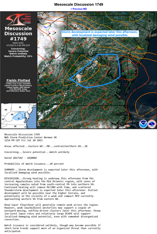
not too much hope for today per pity meso from SPC:
-
5 minutes ago, 09-10 analogy said:
It'll be interesting to see if the powerful storms moving thru MOCO/NVA can lay down any boundaries that may goose (or perpetuate) the storms lining up on I-66 in the Front Royals area, so that (yes, MBY) NW DC can get in on some good stuff a bit later.
https://weather.cod.edu/satrad/nexrad/index.php?type=LWX-N0Q-1-24
can see some semblance of outflow in this loop (at least as of right now, 5:43PM) moving S or SSE from the storms up in Loudoun/Montgomery
-
2
-
The Weekend Rule? Saturday 2/17 - The Icon Storm
in Mid Atlantic
Posted
hate to state the obvious but if we see Cantore anywhere near our area...