

ChescoWx
-
Posts
9,575 -
Joined
-
Last visited
Content Type
Profiles
Blogs
Forums
American Weather
Media Demo
Store
Gallery
Posts posted by ChescoWx
-
-
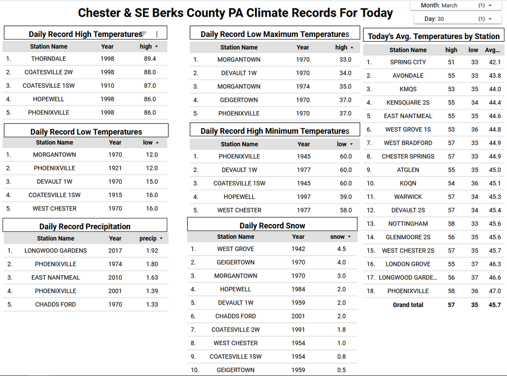
The backdoor cold front went a good bit further SW than earlier forecast. All of Chester County remains in the 40's at 10am. As I mentioned yesterday I suspected the NWS forecast highs for today (low 70's yesterday) may need to be trimmed by as much as 10 to 15 degrees. The NWS has started to move in that direction with most forecasts now having temperatures remaining in the upper 60's....those will likely come down further as the cool moist marine flows off the very chilly 44-degree ocean water temperatures. I actually suspect especially NE Chesco to get no higher than the 50's....a tough forecast for sure but clearly much chillier than yesterday. Some rain tonight with a better chance of rain arriving toward the start of tomorrow's Phillies Home Opener (Go Phils!) If they need to move the game to Tuesday it will be below normal temperatures but sunny with highs in the low 50's here in Chesco.

-
Still 66.3 here in NW Chesco....5 miles east of here in Chester Springs 54
-
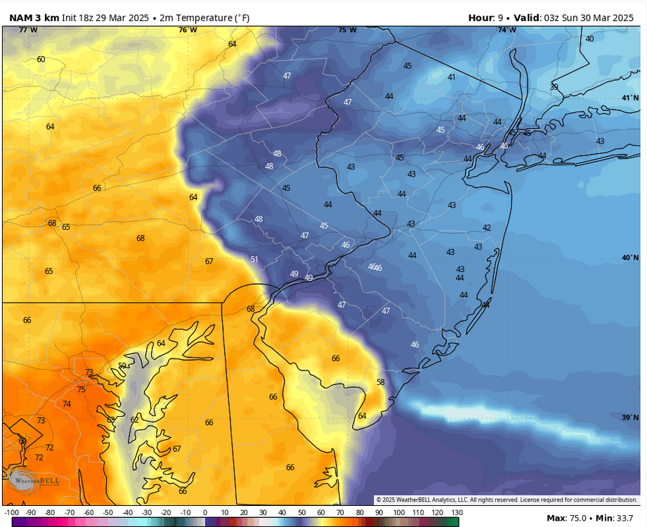
A very very tough temperature forecast as I mentioned this morning. We reached 82.2 degrees here in East Nantmeal this PM....but a backdoor cold front is on the march from off the relatively very cold mid 40's ocean. The National Weather Service has lowered their low temps to the upper 40's now across NW Chesco....some of the latest models (not a forecast model temps at 11pm tonight from the NAM) have 40's across NE Chesco to still near 70 degrees across SW Chester County. If the NAM model is correct we may never get out of the chilly 50's tomorrow across much of Northern Chesco despite the current NWS Forecast of high temps in the low 70's. Should be interesting!
-
Our warmest day since early November is on tap today across the area. Here in East Nantmeal we are already up to 73 degrees here at 1030am. Some valley locations across the area could reach or exceed 80 degrees today! This is nowhere near the County record of 88 degrees back in 1945. A backdoor cold front moving from NE to SW will try to cross the area toward midnight tonight. How far SW this front makes will make a huge difference across our area tomorrow. Currently the National Weather Service has highs tomorrow in the lower 70's here in East Nantmeal. This assumes the front remains NE of our area. However, some of the latest models suggest the front may almost make it to the Mason Dixon line. If this occurs we may see high temperatures, especially across Northern Chester County being at least 10 to 15 degrees lower than the current forecast. A 20-degree difference is possible from the upper 40's to the north to the 70's to the south. Rain chances to increase by Monday morning with some models showing as much as an inch of rain by late Monday night.
-
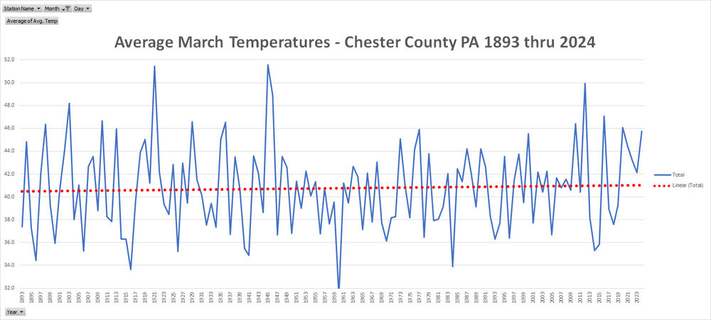
After our below normal temperature winter across the county we have now seen a much warmer than normal March. Through today we are at the 25th warmest March since 1893. With warmer days before we finish the month we could finish close to a top 10 warm Month. Below is the average temperature trend line for all March months since 1893. Average temperatures have clearly not changed much over the past 132 years across the area.
-
 1
1
-
 1
1
-
-
After our below normal temperature winter across the county we have now seen a much warmer than normal March. Through today we are at the 25th warmest March since 1893. With warmer days before we finish the month we could finish close to a top 10 warm Month. Below is the average temperature trend line for all March months since 1893. Average temperatures have clearly not changed much over the past 132 years across the area.
-
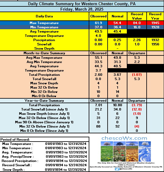
A bit warmer today before our first 70 degree plus day of the year tomorrow across many of the higher spots across the area. In fact, tomorrow will be our warmest day here in East Nantmeal since the 73-degree reading back on November 7th. Still mild through Monday before a turn to cooler on Tuesday. Some showers are possible this evening, but a better chance of rain arrives Sunday night into Monday night. The Phillies home opener on Monday may be delayed till Tuesday.

-
Happy Phillies Opening Day to all who celebrate! Go Phillies!! Today will be our 2nd straight below normal temperature day. Through yesterday we have seen only 5 below normal days this month. We start a big warmup tomorrow and through Monday before we turn sharply colder and fall back below normal by next Tuesday. Slight rain chances on Friday night but a better chance by Sunday night through Monday.
-
 1
1
-
-
13 hours ago, RedSky said:
It likes to snow up here in the Bucks county mountains
We also saw a few flakes here along the soaring peaks of The Welsh Mountain anticline here in Chester County....
-
1 hour ago, chubbs said:
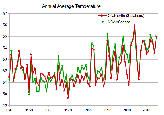
OK, but you need to understand the impact of the 1970 West Chester station move. Before 1970 there is a roughly 1.8F offset between West Chester and NOAA reflecting the warmer West Chester location in the middle of town. Per the chart below, NOAA tracks West Chester closely for the entire 1895-1969 period once the offset is removed. After the move, West Chester cooled and the offset disappeared. Once again NOAA is spot on. After the station moves are accounted for, Coatesville and West Chester validate the entire NOAA series. Phoenixville also confirms the warming over the 1895-2024 period, recognizing that Phoenixville ran too warm during the 1930s-50s, as we discovered last year. That is the vast bulk of the county long-term data supporting NOAA. Where's your validation?
I actually went back and looked at the NCEI adjustments specifically for the West Chester Station (there are some gaps on both the actual and adjusted figures for quite a few years especially in 1910's / 1970's and 1990's) - but from what we have they chilled every single year from 1880 thru 1969...then began additional cooling adjustments from 1979-83 of 0.6 degrees. NCEI then decided to alter the actual data with some of the largest cooling adjustments on record from 1987 thru 1990 of between 3 and 4 degrees each year. To cap it all off they then began to consistently warm the final 10 years of actual data with a steady 0.3 degree warming adjustment made to each of the years between 2007-2017.
-
 1
1
-
-
40 minutes ago, chubbs said:
LOL, you are using plenty of data that isn't "certified" NWS Cooperative, your own house to start with, also DEOS, airport ASOS, etc. You results can't be evaluated without knowing how the Chesco station network has changed with time and you don't provide that information. The first thing a technical group would want to see is something similar to the chart I posted above. How many of your readers know that the early Coatesville data is from the City of Coatesville or that the station cooled significantly when it was moved after the war. We've been discussing Coatesville for years and that was news to me until I found out for myself last year.
Sorry Charlie - the DEOS data is actually runs operationally by NCEP and all of this data has been QC'd and added to NOAA's data archive and is being used by the NCDC. The data above was in reality run without "my house". It is only NWS QC data. So which of my data has not been certified by the NWS??
-
 1
1
-
-
19 minutes ago, chubbs said:
Interesting test of Grok. I'd give it a failing grade. This statement says it all: "@ChescoWx's refusal to share raw data or engage peer review undermines their case". How can you give "partial merit" to Chescowx's claims if you don't know what was done. The reality is that Chesco's claims are flat-out wrong. The raw data shows plenty of warming in Chester County, but he doesn't know how to analyze it. Per chart below, Chescowx's monitoring network has changed significantly. The stations of the past tended to be warmer. Chescowx takes a simple average and Its well known that a simple average of a changing temperature station network skews the results. No wonder he can't find the local warming.
Recognize that it is hard for Grok to evaluate Chescowx, since the methods aren't fully disclosed and Chescowx is constantly overselling his analysis. A problem with Grok, though if it can't distinguish between BS and science.
There is another technical problem here that Grok should detect even if they know nothing about Chescowx's methods. Weather data and climate trends are correlated over hundreds of kilometers. This was established long ago by testing temperature data. There is no indication that Chester county is behaving differently from nearby counties.
Finally both NOAA and Chescowx have track records. No one complains about NOAA's climate analysis in a technical forum. On the contrary, there are many papers that demonstrate sound results, including independent tests with synthetic data. Meanwhile Chescowx has no publication in any technical forum and is constantly repeating climate denier talking points.
Grok's performance here makes me question the value of AI. Perhaps the training on twitter is the problem. Garbage in garbage out.
LOL! Charlie knows my data is available and not hidden. Anyone can obtain and analyze the data. It is all public data. The data is the data! My methods are fully and completely disclosed. My method is to only include the actual certified NWS Cooperative Data....nothing more! No data manipulation so no methods - just raw and the facts!!
-
1
-
-
20 hours ago, HailMan06 said:
No please not this again with Chesco.
LOL!!! You will note in the above I asked Charlie to take it to the Chesco thread where we are continuing the debate....
-
1
-
-
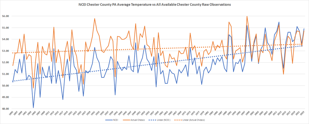
@TheClimateChanger in case you forgot - below is the available on the internet raw data and the analysis comparing the Actual Raw data vs the altered NCEI Data for Chester County PA. This clearly shows Chesco has not warmed 2 degrees (see orange actual raw temps) according to the unaltered data. However, you can clearly see in the blue line the altered post hoc data in blue that does show that warming that can only be accomplished by recasting the actual data and ignoring all of the actual raw data in Chester County.
-
1
-
-
Thanks @TheClimateChangerExcellent!! Likely but.....drum roll please "we can’t definitively say Chester County hasn’t warmed at all. "
Fake news if it was Grok to " @ChescoWx’s refusal to share raw data or engage peer review undermines their case. Extraordinary claims need extraordinary evidence, and they’re light on the latter"
I have often shared my raw data file plus it is all available via the internet. It is available upon request to anyone. Let me know if you want it?
-
1
-
-
29 minutes ago, TheClimateChanger said:
Grok even mentions me! It cannot confirm!!! "Without specific data for Chester County, PA, from NCEI’s raw versus adjusted records, I can’t confirm the exact nature or extent of changes for that location. However, local weather enthusiasts, like those at chescowx.com, have noted that NOAA/NCEI adjustments have historically "chilled" Chester County data from 1893 to 2005 and "warmed" more recent years.
-
1
-
-
24 minutes ago, chubbs said:
Nice insult at the end. What I have come to expect when we exchange data/information. I have shown you umpteen charts which validate NOAA. You dismiss/deny them all. Here's another. After the big moves, Coatesville and NOAA had exactly the same warming between 1948 to 2024. Once again NOAA is spot on.
Now you jump to another time period....let's stay focused on the period in question (1927-1947). Show us some actual data for the period we are looking at above that validate NOAA/NCEI adjusting all temperatures lower than any thermometer anywhere in the county recorded during those 21 years in question.
-
1
-
-
12 hours ago, chubbs said:
The circled yellow numbers and your "post hoc adjustment" rows are meaningless and don't shed any light on NOAA's work. Why? The average of the city of Coatesville, Phoenixville, West Chester Borough, and West Grove is not the county average, not even close. Those stations are all warmer than the county as a whole. Of course the NOAA number is cooler, that isn't surprising at all.
So you are admitting there is no actual annual average thermometer readings that you can show us in the entire county for that period that support the cooler altered NOAA/NCEI data for even one of those 21 years of data across all of those stations?? Hello McFly......
-
1
-
-
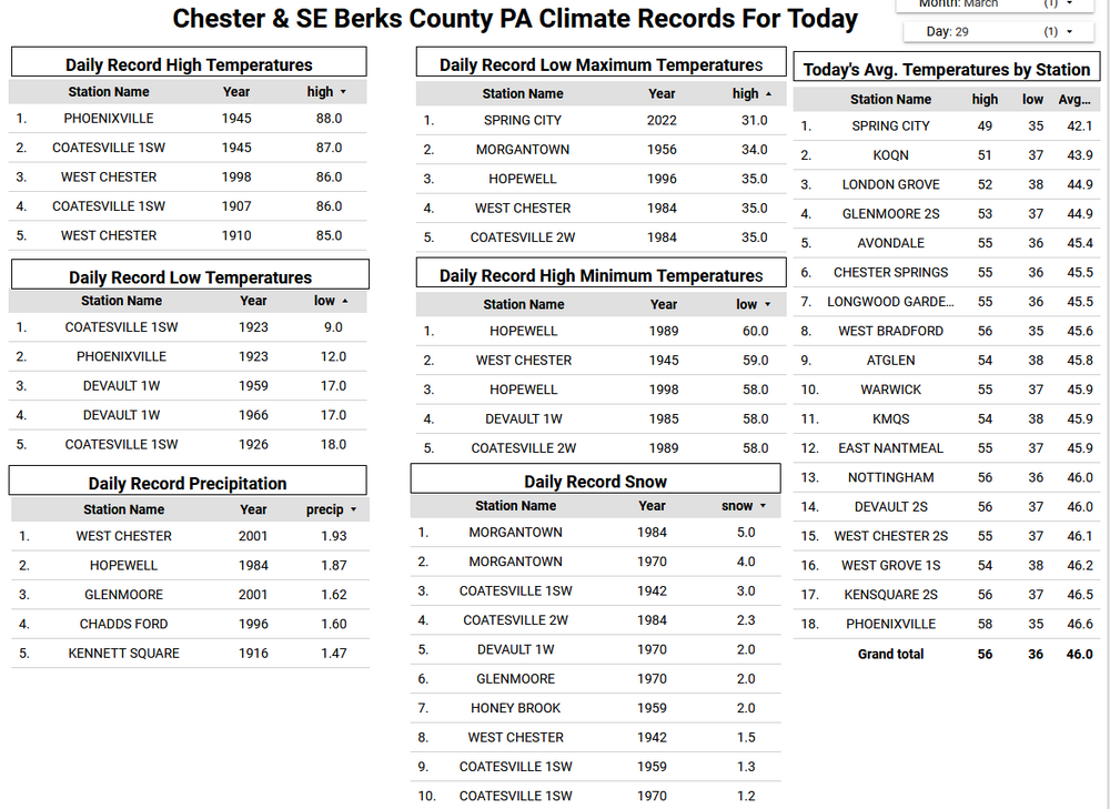
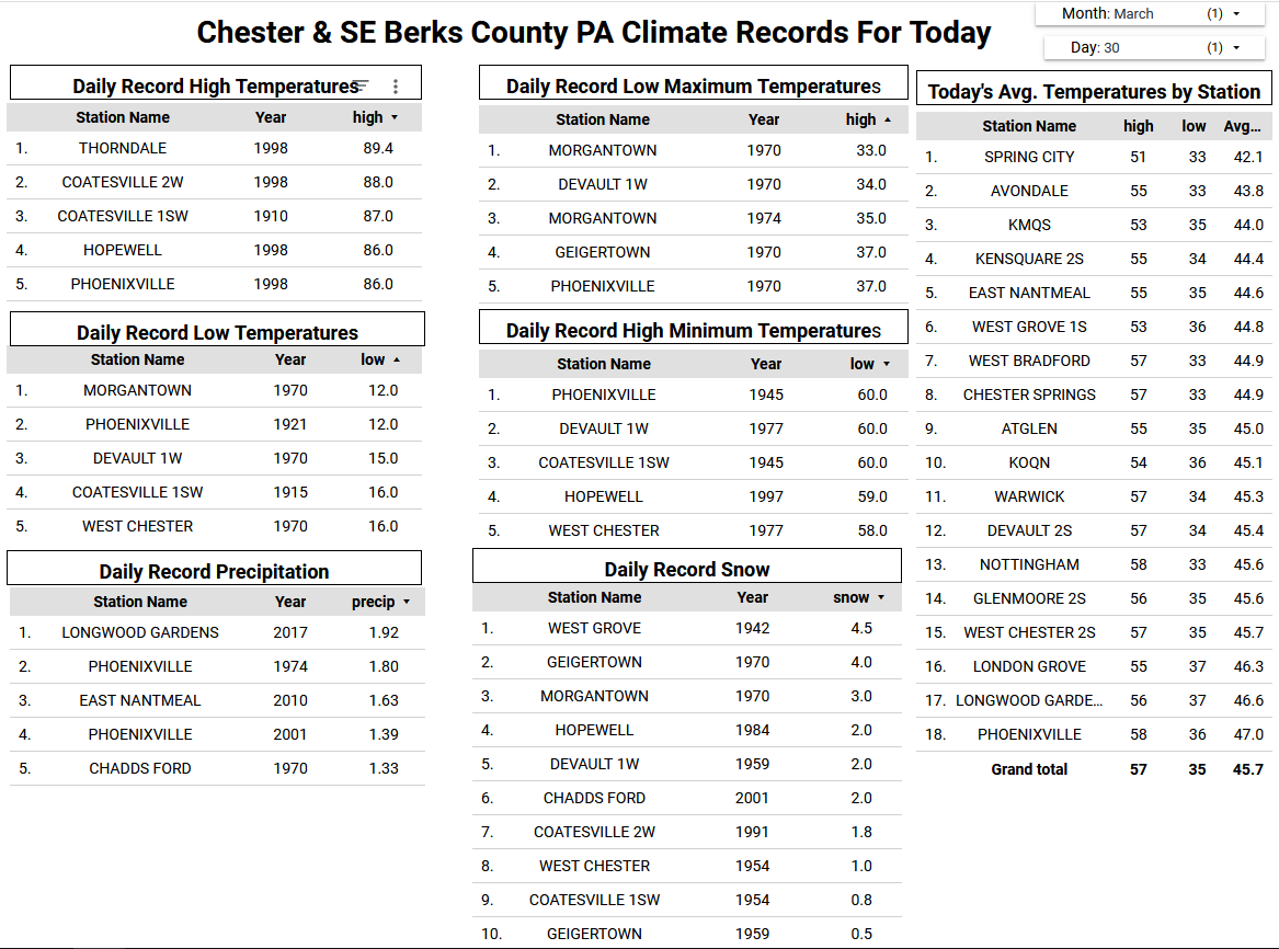
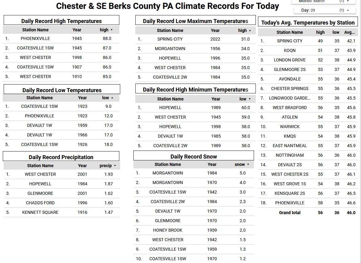
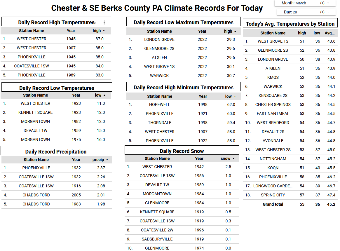
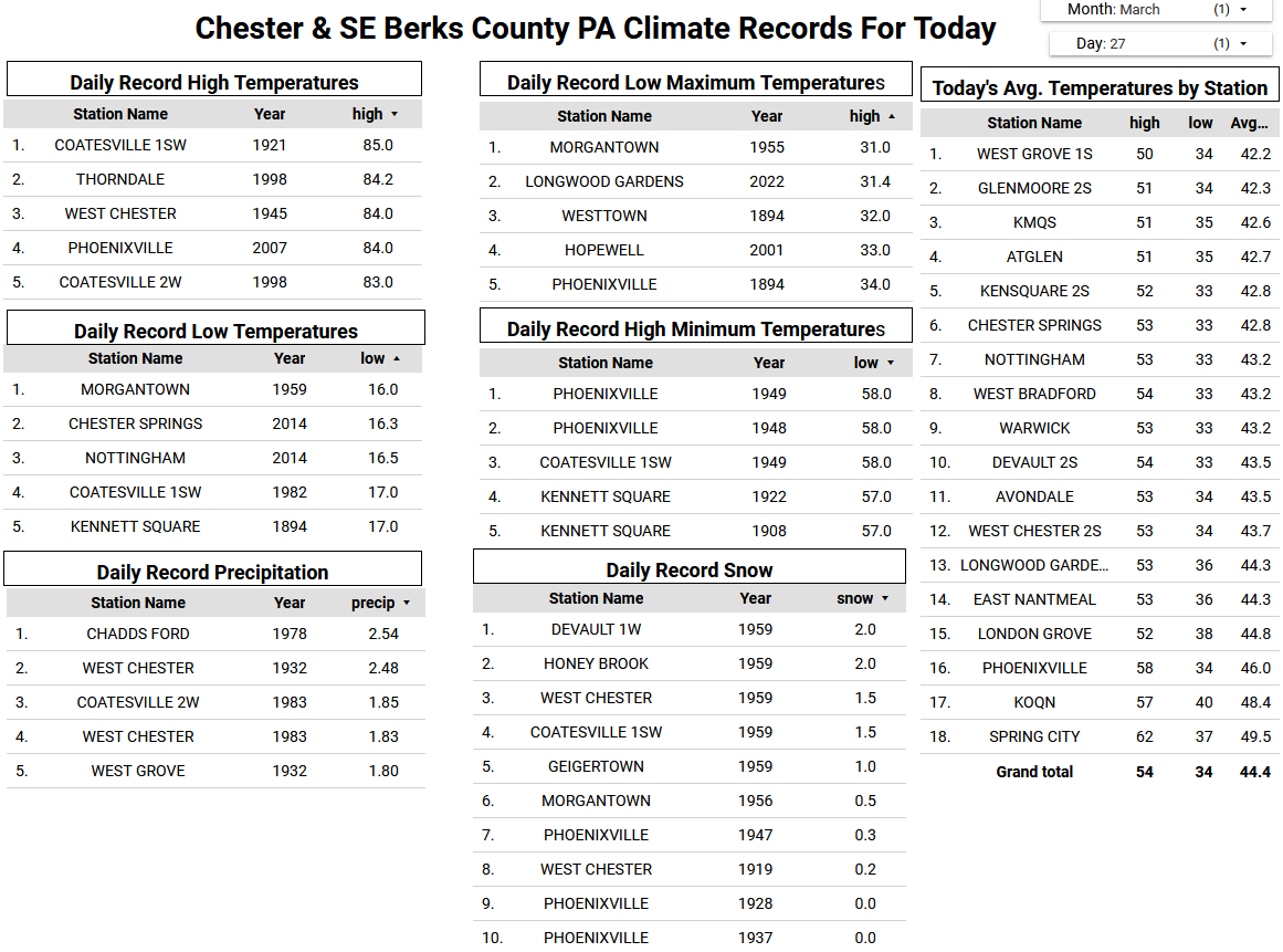
Chillier than normal for late March both today and tomorrow with highs today in the upper 40's. A below freezing night on tap tonight for most of the area. We start a nice warming trend on Friday through Monday before we turn colder than normal again by Tuesday. A slight chance of rain late Friday night with better chances by Sunday night into Monday.
-
Chillier than normal for late March both today and tomorrow with highs today in the upper 40's. A below freezing night on tap tonight for most of the area. We start a nice warming trend on Friday through Monday before we turn colder than normal again by Tuesday. A slight chance of rain late Friday night with better chances by Sunday night into Monday.


Central PA Spring 2025
in Upstate New York/Pennsylvania
Posted
The backdoor cold front went a good bit further SW than earlier forecast. All of Chester County remains in the 40's at 10am. As I mentioned yesterday I suspected the NWS forecast highs for today (low 70's yesterday) may need to be trimmed by as much as 10 to 15 degrees. The NWS has started to move in that direction with most forecasts now having temperatures remaining in the upper 60's....those will likely come down further as the cool moist marine flows off the very chilly 44-degree ocean water temperatures. I actually suspect especially NE Chesco to get no higher than the 50's....a tough forecast for sure but clearly much chillier than yesterday. Some rain tonight with a better chance of rain arriving toward the start of tomorrow's Phillies Home Opener (Go Phils!) If they need to move the game to Tuesday it will be below normal temperatures but sunny with highs in the low 50's here in Chesco.