

ChescoWx
-
Posts
9,849 -
Joined
-
Last visited
Content Type
Profiles
Blogs
Forums
American Weather
Media Demo
Store
Gallery
Posts posted by ChescoWx
-
-
Our run of dry and unseasonably cool weather looks to continue through at least the next week. Another cold front is crossing the area today and by later today winds will turn to the west, northwest, and become gusty. Dew points will fall into the 40's by evening and actual air temperatures will likely follow with widespread lows by Saturday morning in the chilly 40's. Some of our usual colder lower valley spots may be in the low 40's with even some 30's not out of the question. Some higher spots may not escape the 60's for highs tomorrow afternoon. Rain chances look low for much of the week before some chances of rain creeping back into the forecast by Thursday.

-
 1
1
-
-
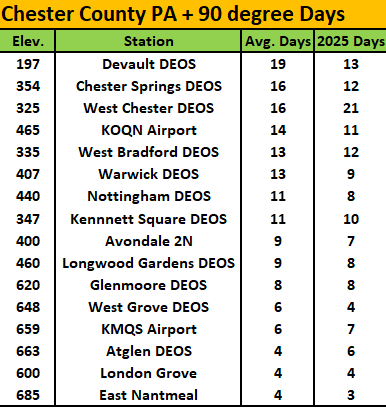
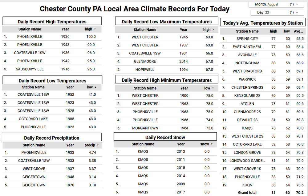
I suspect we are likely done with any more 90 plus days this year. Over at the PHL Airport they saw an above average of 36 such days.....here in Chester County a bit different story. We don't have our usual NWS COOP hot spots (Phoenixville and Spring City) reporting yet but below are current available stations with their 90+ days so far this year vs. each station's average number of such days.
-
 1
1
-
-
I suspect we are likely done with any more 90 plus days this year. Over at the PHL Airport they saw an above average of 36 such days.....here in Chester County a bit different story. We don't have our usual NWS COOP hot spots (Phoenixville and Spring City) reporting yet but below are current available stations with their 90+ days so far this year vs. each station's average number of such days.
-
1 hour ago, Mount Joy Snowman said:
Again, @TimB I'm not sure what's funny about this. You know who else is looking at a really chilly August? MDT, who's likely to finish with its 1st or 2nd coldest August in 30+ years. I'm not here to carry the banner for @ChescoWx or vouch for everything he says, but at this point you're just trying to be a d$ck.
@TimBhas a few "issues" and banners he needs to carry so I just ignore him....
-
2
-
 1
1
-
-
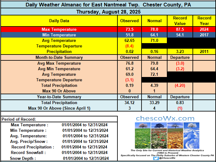
I have calculated the ending average temperature for here in East Nantmeal Township using the current NWS Forecast. If the forecast temperatures verify - this will be the chilliest August since my records begin here from back in 2004 across 22 years of data.
-
I have calculated the ending average temperature for here in East Nantmeal Township using the current NWS Forecast. If the forecast temperatures verify - this will be the chilliest August since my records begin here from back in 2004 across 22 years of data.
-
1
-
1
-
-
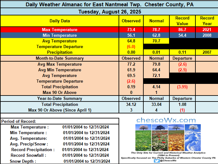
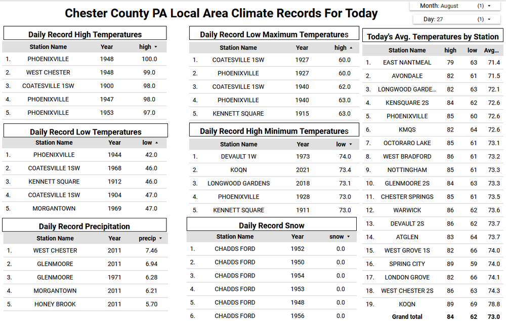
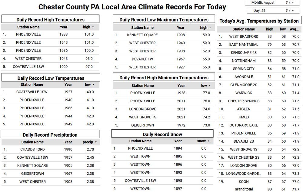
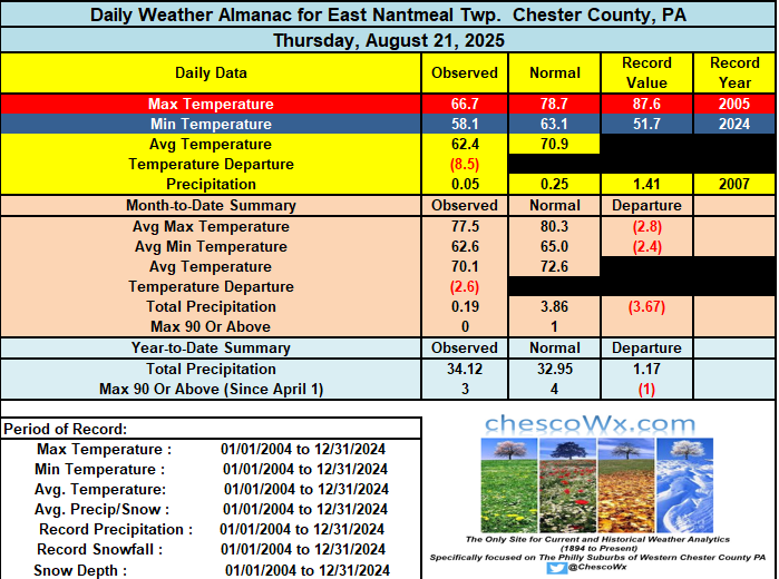
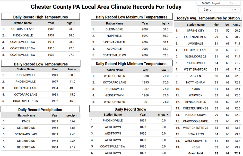
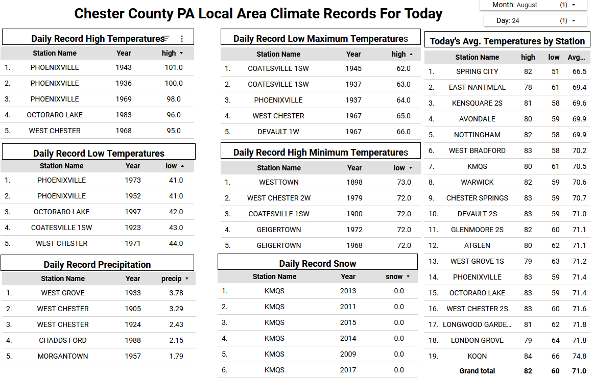
Of note that 45.9 degree low temperature this morning at Warwick Township is the 2nd coldest temperature recorded in the county on this date behind only the 42 degree low back in 1944 at Phoenixville.
-
3
-
1
-
-
Of note that 45.9 degree low temperature this morning at Warwick Township is the 2nd coldest temperature recorded in the county on this date behind only the 42 degree low back in 1944 at Phoenixville.
-
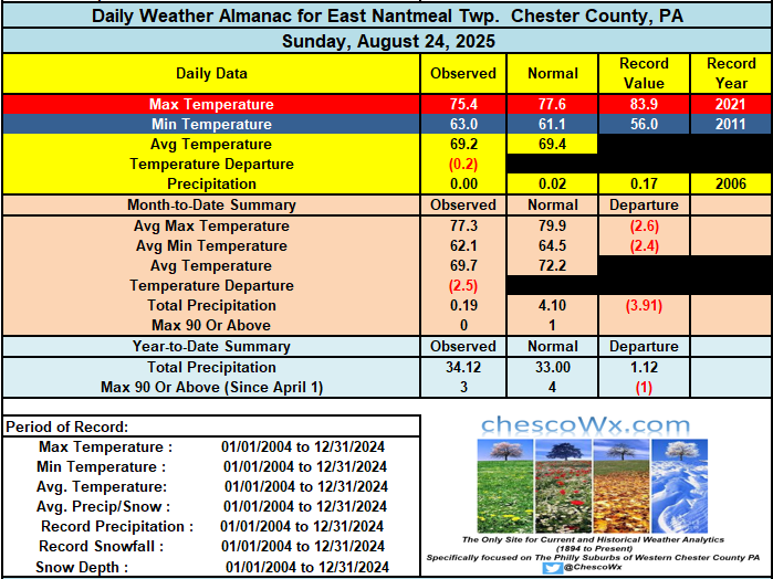
This morning was our chilliest morning of the late summer/early fall season. Many of the area lower valley spots fell into the mid to upper 40's including Warwick Township at 45.9 / Nottingham 47.0 / Avondale 49.5 / Kennett Square 48.7 / West Bradford 47.8. The higher ridge locations stayed in the lower 50's. We should see a repeat with similar temperatures tonight. Our below normal temperatures will continue through the week and into next week. The "mildest" day looks to be tomorrow, but it will still feature temperatures still several degrees below normal for the end of August. Another cold front crosses the area tomorrow night and we should again see nights in the 40's for those valley locations both Saturday and Sunday morning. Only a very slight chance of a shower on Friday otherwise another dry week in what has been one of our driest August months on record.
-
1
-
-
On 8/25/2025 at 11:32 AM, Mount Joy Snowman said:
I may regret this but @TimB may I ask why you have started putting laughing emojis on most of @ChescoWx's posts? I mean, if you just don't like the guy or disagree with some of his general themes, that's fine, but laughing at every post seems a bit much. Most of the posts are just brief summaries and forecasts that aren't controversial in any way. As an example, below is his post from last Wednesday, which I believe is the first one you started mocking. I can't think of a more benign harmless post. Food for thought.
"We saw some light rain amounts overnight and this early AM including 0.05" at both Glenmoore and East Nantmeal. Shower chances will continue both today and tomorrow with continued cooler than normal temperatures. We clear up Friday and Saturday with our temperatures rebounding to near normal before a cold front moves through on Sunday which will allow for the return of an autumnal feel in the air."
Thanks Mount Joy!!
-
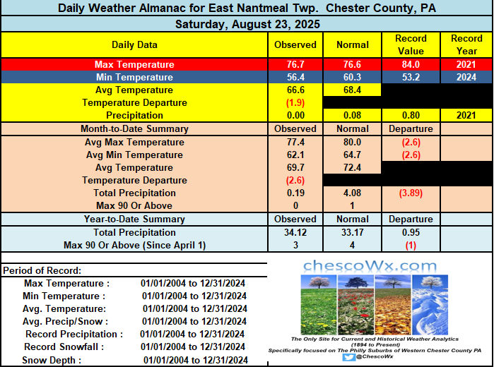
Unfortunately, the cold front passed with nothing more than some drizzle in spots. The good news is that likely the best weather week of the year is underway! Today will be the warmest day but not too far from average for the date. Tonight we fall into the 50's for lows which will continue each night for at least the next week. I suspect by Thursday and Friday morning we may see some of our chillier valley locations fall into the 40's. Highs throughout the week will be in the low to mid 70's with low humidity. Enjoy!
-
1
-
-
Unfortunately, the cold front passed with nothing more than some drizzle in spots. The good news is that likely the best weather week of the year is underway! Today will be the warmest day but not too far from average for the date. Tonight we fall into the 50's for lows which will continue each night for at least the next week. I suspect by Thursday and Friday morning we may see some of our chillier valley locations fall into the 40's. Highs throughout the week will be in the low to mid 70's with low humidity. Enjoy!
-
-
Today will be the warmest and somewhat humid day for the rest of August. A couple showers are possible late today and tonight with a cold front. Here in East Nantmeal we could really use the rain as we are well on the way to finishing this August as the driest such month since I began keeping records in 2004. So far I have only measured a scant 0.19" in August. The previous low month was back in 2005 when only 1.24" fell. This next week may be one of the best weather weeks of the year! Autumnal weather with low humidity and unseasonably cool temperatures for the final week of August. Highs on Wednesday will struggle to escape the 60's for high temperatures across the higher ridge areas. Highs for the week will be mainly in the low to mid 70's with nights well down into the 50's with some 40's possible in valley locations.
-
1
-
-
A nice weekend underway with temperatures today through Monday close to our average high temperature around 80 degrees for the end of August. We turn much cooler by Monday night and that should last through much of next week. Some of the typically colder valley locations may see lows by both Wednesday and Thursday night in the upper 40's. Highs by mid-week may barely escape the 60's across the higher ridges across the area. We continue to be very dry across Northern Chester and SE Berks counties so far here in August. Our best chance of a little is tomorrow night.
-
Great example of poorly sited thermometers like my Tempest on the rooftop - high up there 84 - All other stations DEOS etc. at my elevation in 70s to near 80-81 degrees for highs
-
Great example of poorly sited thermometers like my Tempest on the rooftop - high up there 84 - All other stations DEOS etc. at my elevation in 70s to near 80-81 degrees for highs
-
Some of the typically colder spots like Warwick Township made it down to 50.8 degrees this morning. A nice rebound in temperatures today but still below normal levels for late August. This pattern looks like it will continue for the upcoming week with the chilliest air so far this incoming fall season arriving by mid-week. Lows by Wednesday and Thursday morning may reach the 40's in the colder lower spots across the area. Temperatures through Monday will be not too far from normal in the upper 70's to low 80's. By Tuesday and Wednesday some of the ridge stations may struggle to get out of the 60's for afternoon highs. Rain has especially northern areas has been very scarce so far in August. Our best chances of rain this week looks like Sunday night.

-
1
-
-
Some of the typically colder spots like Warwick Township made it down to 50.8 degrees this morning. A nice rebound in temperatures today but still below normal levels for late August. This pattern looks like it will continue for the upcoming week with the chilliest air so far this incoming fall season arriving by mid-week. Lows by Wednesday and Thursday morning may reach the 40's in the colder lower spots across the area. Temperatures through Monday will be not too far from normal in the upper 70's to low 80's. By Tuesday and Wednesday some of the ridge stations may struggle to get out of the 60's for afternoon highs. Rain has especially northern areas has been very scarce so far in August. Our best chances of rain this week looks like Sunday night.
-
Some light showers are possible this morning part otherwise cloudy, and another below normal temperature day across the area. We clear up both tomorrow and Saturday before shower chances increase on Sunday. Some valley locations may reach the low 80's tomorrow and Saturday. After that we will not touch 80 degrees for the remainder of August as we have much cooler weather moving next week. Some valley locations may even reach the 40's for overnight lows next week. Some great autumnal like weather on the way. Our next rain chances are Sunday.
-
1
-
-
Some light showers are possible this morning part otherwise cloudy, and another below normal temperature day across the area. We clear up both tomorrow and Saturday before shower chances increase on Sunday. Some valley locations may reach the low 80's tomorrow and Saturday. After that we will not touch 80 degrees for the remainder of August as we have much cooler weather moving next week. Some valley locations may even reach the 40's for overnight lows next week. Some great autumnal like weather on the way. Our next rain chances are Sunday.
-
1
-


Central PA Summer 2025
in Upstate New York/Pennsylvania
Posted
Our run of dry and unseasonably cool weather looks to continue through at least the next week. Another cold front is crossing the area today and by later today winds will turn to the west, northwest, and become gusty. Dew points will fall into the 40's by evening and actual air temperatures will likely follow with widespread lows by Saturday morning in the chilly 40's. Some of our usual colder lower valley spots may be in the low 40's with even some 30's not out of the question. Some higher spots may not escape the 60's for highs tomorrow afternoon. Rain chances look low for much of the week before some chances of rain creeping back into the forecast by Thursday.