

ChescoWx
-
Posts
7,516 -
Joined
-
Last visited
Content Type
Profiles
Blogs
Forums
American Weather
Media Demo
Store
Gallery
Posts posted by ChescoWx
-
-
12 hours ago, chubbs said:
As usual you are jumping to the wrong conclusion based on lousy analysis. You aren't controlling for differences in average temperature between stations. Every time you change the stations included in your County average, you get a different result. To get a cooler result add in some relatively cool stations. I don't see any recent "warming adjustment" for NOAA when I compare to your own Chescowx series. Quite the contrary NOAA and Chescowx are in good agreement on the warming rate over the past 54 years. Good news for your post-1970 data.
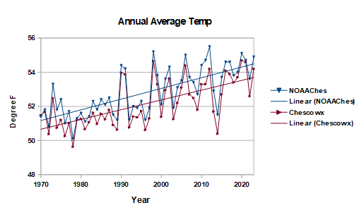
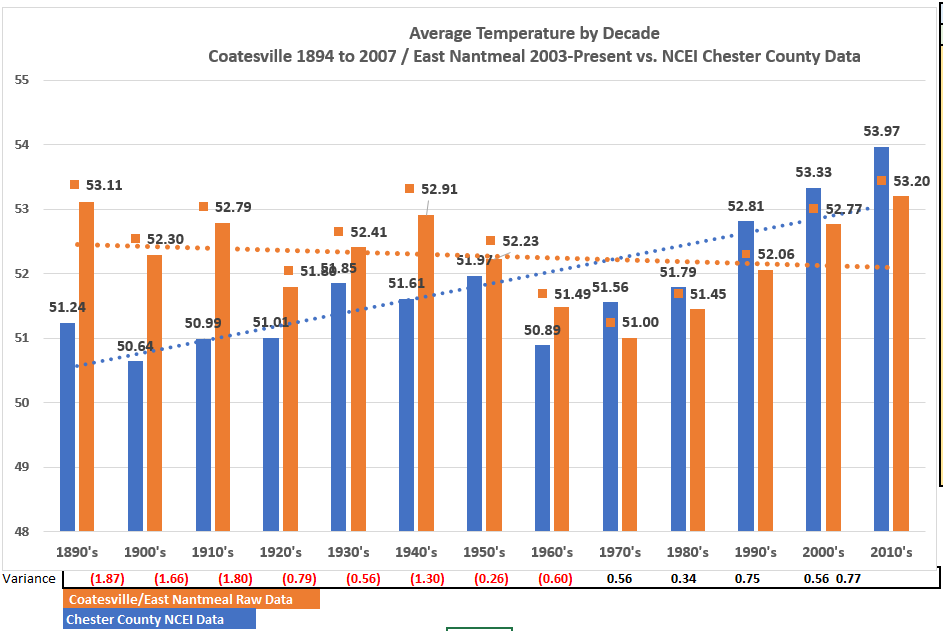
So let's correct your above with the actual raw data analysis below. What you call ChescoWx above let's break it into just the actual 3 stations (not the up to 24 stations we have in the actual data) Coatesville 1E / Coatesville 2W and East Nantmeal averaged together vs. the NCEI adjustments. You can clearly see the warming adjustment - now up to 0.77 degrees in the most recent complete decade! So they cooled the first 8 decades and warmed the last 4 - voila that gives you the blue warming line vs. the actual data not warming at all and in fact showing cooling.
-
4 hours ago, TheClimateChanger said:
It's important to note when people complain about adjustments to the temperature record, what they are really saying is that they want to use flawed data because it gives them a more favored result. Time of observation makes a HUGE difference, especially in the summertime when weather variance tends to be at an annual minimum. We know this, and we correct for it.
Time bias does not make a material difference as long as consistent obs are taken over 365 days - while making post observation chilling adjustments for 111 straight years and then warming the last 20 does not give anyone comfort in the data and trends is purports to show. I actually went back and recast my observations from 8pm to the current 24 hours for 3 years of data. The difference was less than 0.002 degrees.
-
Yesterday was the warmest day (65.1) in East Nantmeal since the 66.3 degree reading on November 9th. Other Chester County high temps yesterday included Atglen 65.2 / Chester Springs 66.7 / Devault 67.2 / Glenmoore 65.0 / Longwood 65.2 / Marshallton 67.8 / Warwick 67.9 and West Chester 66.7. Both today and tomorrow should be even a bit warmer but nowhere close to record levels before showers Friday and a turn to much colder weather next week.Records for today: 84 degrees at Glenmoore/Honey Brook / Chadds Ford and West Chester (1990) / Record Low 1 below zero Coatesville (1896) / Rain 3.24 Coatesville Airport KMQS (2010) / Snow 15.2" Coatesville during the Blizzard of 1993.
-
1 minute ago, TimB said:
You’ll stop at nothing to prove your stupid little agenda. Trust me, the last time someone will think about these records you’ve meticulously been keeping for decades will probably be about 3 years after you’re dead, maybe less. Is it even worth it?
You have to admit it is kind of strange that the NCEI had to adjust each and every year from 1895 for 111 years and then warm the last 20 to make that trend line look scary. However. I suspect you are right that some day all we will have is the adjusted post observation tweaks as the record. Data from the original observers will be deleted and forgotten and folks will never know what we did to the actual real data to make it so scary!!
-
3 minutes ago, TimB said:
72.7 to 73.3 is still warming.
LOL!!!! non statistical p-value over that long a period!!!
-
 1
1
-
-
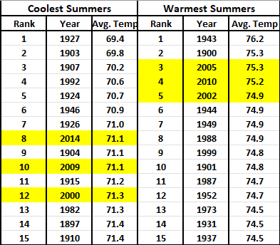
Since 1895 Coolest and Warmest Summers in Chester County PA - 3 of the coolest top 15 since 2000 and 3 of the top 5 warmest since 2000.....can you say cycles??
-
1 minute ago, TimB said:
This doesn’t belong in regional subforums. But good to see you admit that your flawed data and the NCEI data both show warming.
Nothing flawed in my all encompassing data LOL!! is all of the available actual non adjusted data and it shows no statistically significant warming at all....unless you apply the "post observation" NCEI adjustments!
-
1
-
-
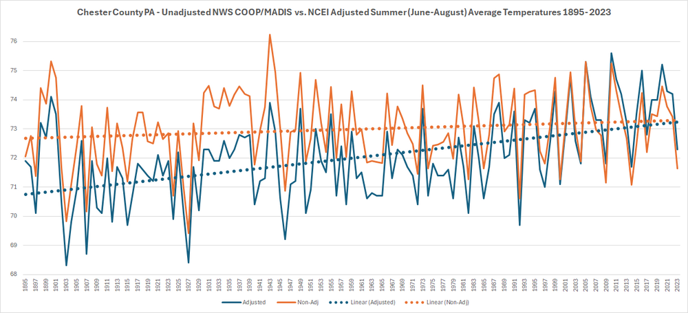
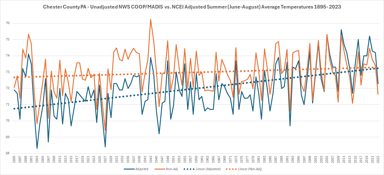
I have been working with the great folks at the Delaware Environmental Observing System (Thanks to Chris!!) to add even more weather observation points and stations across Chester County PA. With the updated data and summer coming I thought I would run an analysis of Summer (June-August) temperatures across the County from 1895 through last summer (now with 25 Chester County Stations at least partially in the data since 1895 and 15 current observation sites included). Overall in the non-adjusted data there is only as expected normal cyclical warm and cool cycles but I thought I would show you a comparison of the post observation adjustment applied by the the National Center of Environmental Information (NCEI) who have applied an incredible 111 consecutive years of post observation adjustments to chill the actual observations to each and every summer from 1895 through 2005 and have now every year since 2005 now applied a warming adjustment. As you can see in the trend lines the orange non-adjusted and blue adjusted paint a far different rate of our rate of warming. My friend Charlie will of course tell us these 111 straight years of cooling adjustments and now 20 years of warming are science based.....
-
I have been working with the great folks at the Delaware Environmental Observing System (Thanks to Chris!!) to add even more weather observation points and stations across Chester County PA. With the updated data and summer coming I thought I would run an analysis of Summer (June-August) temperatures across the County from 1895 through last summer (now with 25 Chester County Stations at least partially in the data since 1895 and 15 current observation sites included). Overall in the non-adjusted data there is only as expected normal cyclical warm and cool cycles but I thought I would show you a comparison of the post observation adjustment applied by the the National Center of Environmental Information (NCEI) who have applied 111 consecutive years of post observation adjustments to chill the actual observations to each and every summer from 1895 through 2005 and have every year since 2005 now applied a warming adjustment. As you can see in the trend lines the orange non-adjusted and blue adjusted paint a far different rate of our rate of warming.
-
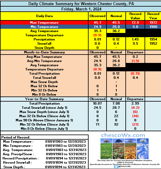
Beautiful stretch of weather starts today through Thursday. Temps rising into the low 60's today to upper 60's by Thursday. Next chance of showers Thursday night into Friday AM.Chester County records: High 84 West Chester (1990) / Low 1 above Phoenixville (1934) / Rain 1.68" West Grove (1936)/ Snow 4.3" East Nantmeal (2022)
-
1
-
-
Beautiful stretch of weather starts today through Thursday. Temps rising into the low 60's today to upper 60's by Thursday. Next chance of showers Thursday night into Friday AM.Chester County records: High 84 West Chester (1990) / Low 1 above Phoenixville (1934) / Rain 1.68" West Grove (1936)/ Snow 4.3" East Nantmeal (2022)
-
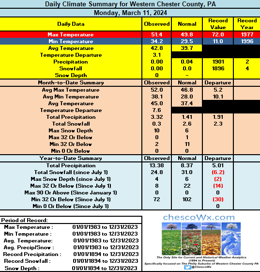
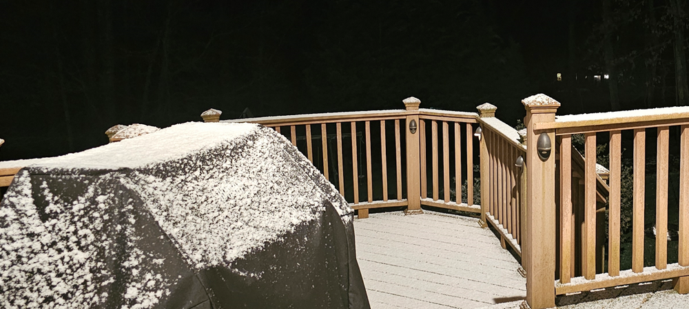
Along with our 0.3" of snow last evening was our first below freezing temperature since March 1st. Wind advisory remains in effect till 8pm tonight. Near normal temps today before a nice warming trend starts tomorrow. Some southern parts of Chesco could even touch 70 degrees by Thursday. Next week will be quite a bit cooler.
County wide records for today: High 82 West Chester (2016) / Low 6 Phoenixville (1960) / Rain 2.60" Glenmoore (2011) / Snow 4.5" West Grove (1934)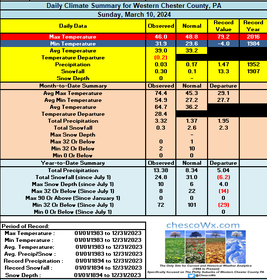
-
1
-
-
Along with our 0.3" of snow last evening was our first below freezing temperature since March 1st. Wind advisory remains in effect till 8pm tonight. Near normal temps today before a nice warming trend starts tomorrow. Some southern parts of Chesco could even touch 70 degrees by Thursday. Next week will be quite a bit cooler.
County wide records for today: High 82 West Chester (2016) / Low 6 Phoenixville (1960) / Rain 2.60" Glenmoore (2011) / Snow 4.5" West Grove (1934) -
We picked up 0.3" of snow here in East Nantmeal our 5th straight month with measurable snowfall.
-
2
-
-
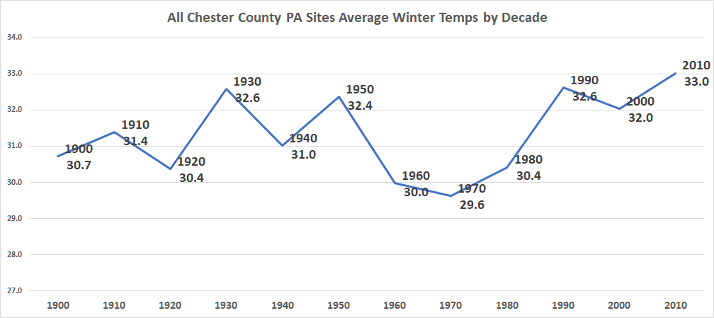
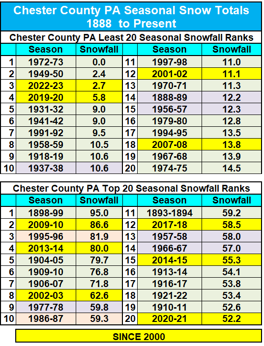
Below by decade are complete winter (Dec-Jan-Feb) average raw non-NCEI adjusted temperatures for all available Chester County PA Stations (22 total stations since 1900) as expected very cyclical in nature with the warmest decades being the 1930's / 1950's / 1990's and 2010's

-
-
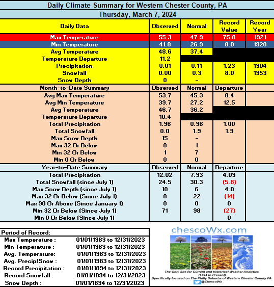
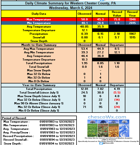
The first 7 days of March have been the warmest start to March in 20 years (2004). The warmest start in March history across all available Chester County sites was 50 years ago back in 1974. We look to turn chillier with closer to normal temps over the weekend with temps remaining in the 40's with rain tomorrow into Saturday night. We warm again during the next week before a pattern change to colder than normal starting toward the end of next week. Chester County wide records for today: High 80 degrees at Glenmoore / Honey Brook and Coatesville (2000) / Low zero West Chester (2007) / Rain 2.96" Coatesville (1995) / Snow 10.7" Phoenixville (1941)
-
1
-
-
The first 7 days of March have been the warmest start to March in 20 years (2004). The warmest start in March history across all available Chester County sites was 50 years ago back in 1974. We look to turn chillier with closer to normal temps over the weekend with temps remaining in the 40's with rain tomorrow into Saturday night. We warm again during the next week before a pattern change to colder than normal starting toward the end of next week. Chester County wide records for today: High 80 degrees at Glenmoore / Honey Brook and Coatesville (2000) / Low zero West Chester (2007) / Rain 2.96" Coatesville (1995) / Snow 10.7" Phoenixville (1941)
-
We continue our wet year as over the last 2 days rain totals ranged from a low of 0.68" at Glenmoore to as much as 1.00" in West Chester. We can a break with some sun and continued mild both today and tomorrow before rain arrives again Saturday. By Sunday morning we could see close to another inch of rain.County wide records for today: High 75 Coatesville (1921) / Low 4 below West Chester (2015) / Rain 2.70" West Grove (1967) / Snow 13.0" West Grove (1962)
-
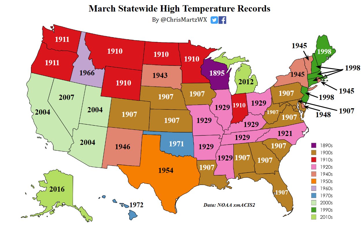
Below is a great list (Thanks Chris Martz) of all-time US by State high temperature records (of course before adjustments NOAA adjustments etc.).
Per Chris "35 states set their “all-time” March monthly record high temperatures prior to 1955. Thirteen states set theirs in 1907 alone, the most in a single year and a single decade. Eight states set their March records in the 1920s, seven of which were in 1929. I ran the numbers by hand from NOAA's database on xmACIS2 and have been consulting with just about every state climatologist to confirm that these are in fact legitimate, as NOAA NCEI only lists records set for all months, not individual months."

-
 1
1
-
-
0.83" of rain so far here in East Nantmeal. Some other area totals Atgen 0.72" /Warwick 0.75" / Chester Springs 0.82" / Glenmoore 0.84"/ Kennett Square 0.96" / West Bradford 0.93" / West Chester 0.93". Rain should continue through much of today with another 0.50" to 0.75" possible. Sun returns tomorrow and temps should get close to 60 degrees.County wide records for today: High 76 degrees Phoenixville (1972) / Low 1 above Phoenixville (1967) / Rain 1.65" West Grove (1954) / Snow 12.0" Devault (1969)
-
1
-

Occasional Thoughts on Climate Change
in Climate Change
Posted
And again below is all stations with up to 17 actual reporting sites included in the most recent 2 decades. The same pattern of large chilling adjustments for 111 years and now increasing warming adjustments as you can clearly see during the past 2 decades. Why the post observation warming adjustments of 0.3 degrees in the 2010's? Is it time of obs? bad equipment? Do we know the exact answer??