(002).png.f2cbd7c955dc3007a02ab79925b174ec.png)
ChescoWx
-
Posts
11,230 -
Joined
-
Last visited
Content Type
Profiles
Blogs
Forums
American Weather
Media Demo
Store
Gallery
Everything posted by ChescoWx
-
(002).thumb.png.6e3d9d46bca5fe41aab7a74871dd8af8.png)
Central PA Summer 2026 Discussion/Obs Thread
ChescoWx replied to Voyager's topic in Upstate New York/Pennsylvania
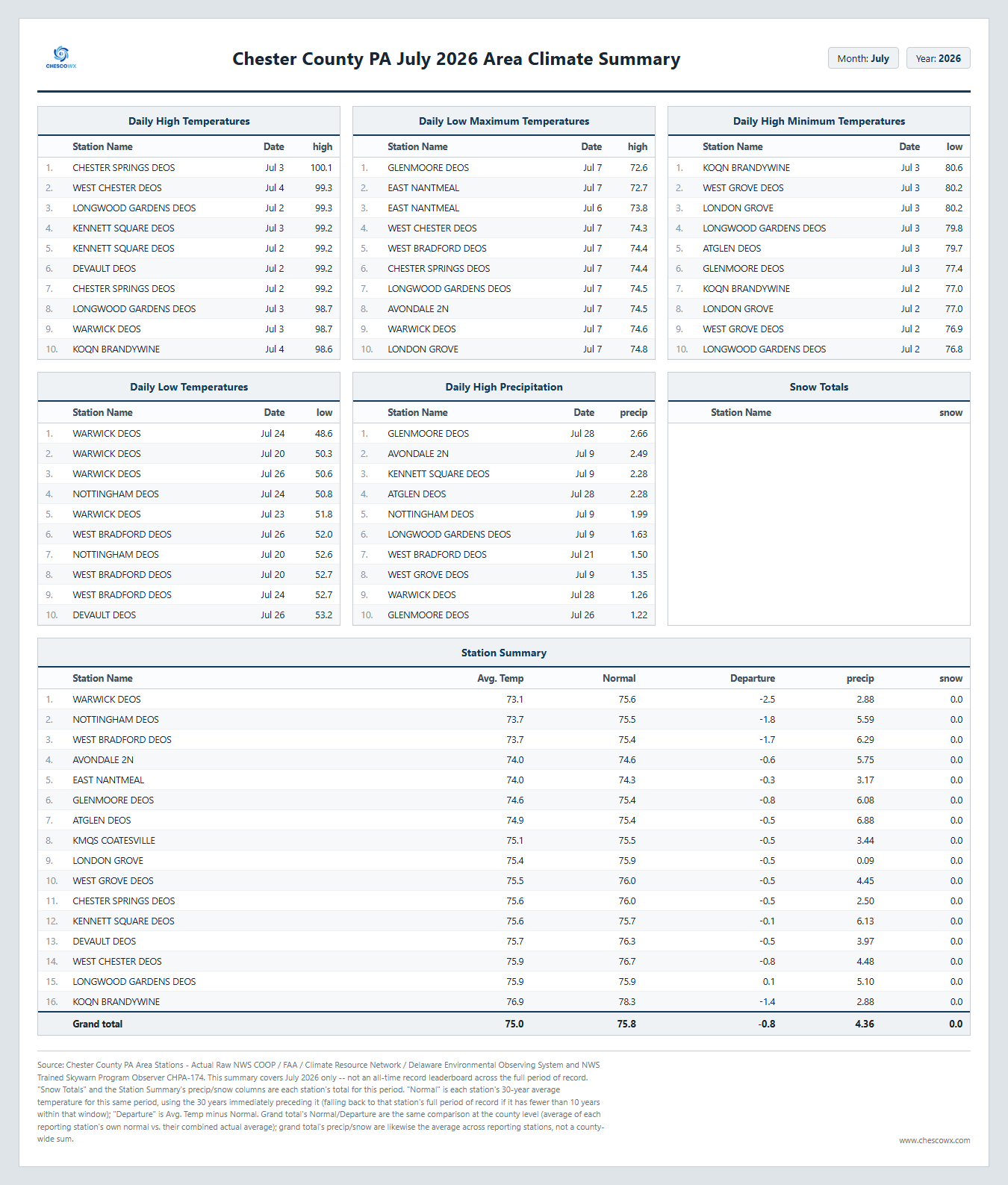
Below is the Chester County PA Climate Summary for July 2026. We finished the month with an average temperature of 75.0 this is 0.8 degrees below normal our average rainfall across the county was 4.36". This was our "chilliest" July since the 74.9 in 2021. Overall we finished as the 61st warmest and 66th driest July over the last 134 years. Our warmest July was the 78.7 in 1999 our coolest July was back in 2009 with an average temperature of only 70.9 degrees. Our wettest on average was the 11.64" average across the county way back in 1919. The dryest on average July was the scant 0.68" average back in 1944. Overall through the first 7 months of 2026 we have an average temperature to date of 51.9 degrees this is 0.5 degrees below the average over the last 30 years and the 61st warmest first 7 months since records began in 1893.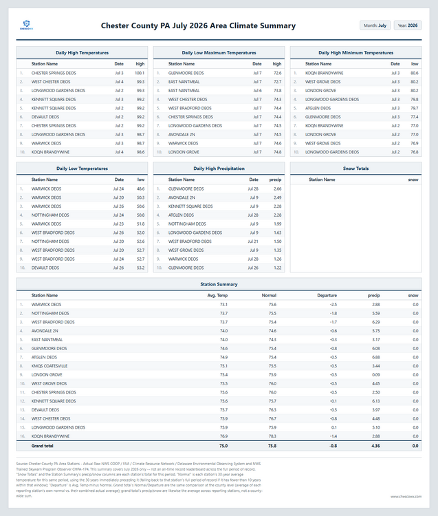
-
E PA/NJ/DE Summer 2026 Obs/Discussion
ChescoWx replied to PhiEaglesfan712's topic in Philadelphia Region
Below is the Chester County PA Climate Summary for July 2026. We finished the month with an average temperature of 75.0 this is 0.8 degrees below normal our average rainfall across the county was 4.36". This was our "chilliest" July since the 74.9 in 2021. Overall we finished as the 61st warmest and 66th driest July over the last 134 years. Our warmest July was the 78.7 in 1999 our coolest July was back in 2009 with an average temperature of only 70.9 degrees. Our wettest on average was the 11.64" average across the county way back in 1919. The dryest on average July was the scant 0.68" average back in 1944. Overall through the first 7 months of 2026 we have an average temperature to date of 51.9 degrees this is 0.5 degrees below the average over the last 30 years and the 61st warmest first 7 months since records began in 1893.
-
Central PA Summer 2026 Discussion/Obs Thread
ChescoWx replied to Voyager's topic in Upstate New York/Pennsylvania
A pretty unsettled weather week on the way with shower chances increasing later today and becoming likely tonight into tomorrow. No washouts except for most likely tomorrow. Tuesday and Thursday look to be the relatively driest days before rain chances increase again to close out the work week. Temperatures this week are close to normal for the start of August.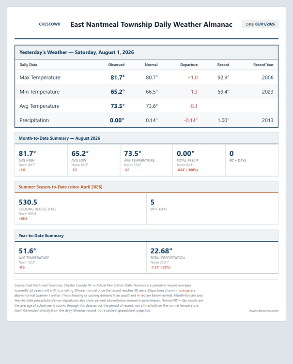
-
E PA/NJ/DE Summer 2026 Obs/Discussion
ChescoWx replied to PhiEaglesfan712's topic in Philadelphia Region
A pretty unsettled weather week on the way with shower chances increasing later today and becoming likely tonight into tomorrow. No washouts except for most likely tomorrow. Tuesday and Thursday look to be the relatively driest days before rain chances increase again to close out the work week. Temperatures this week are close to normal for the start of August.
-
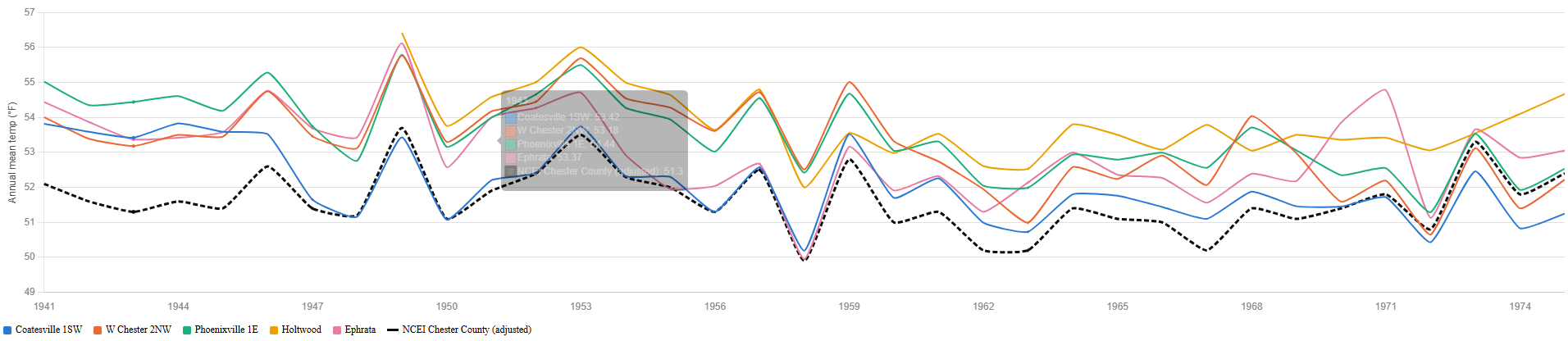
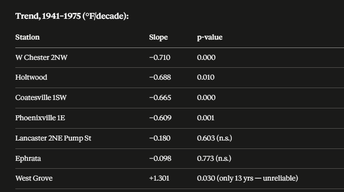
This is a follow up to the earlier Coatesville 1SW review and analysis. The issue surfaced earlier and evaluated further here is to determine if there is support for the NCEI post hoc chilling of all raw data for the consistently reporting Chester County PA stations of Coatesville1SW/ West Chester 2NW and Phoenixville1E from 1941-1975? Keep in mind that without these NCEI chilling adjustments the long-term average annual temperature warming curve for Chester County goes from significant warming based on NCEI adjusted data to clear non statistical warming from 1893 through 2025. So for this pass we went outside of Chester County to find "neighborhood" stations within 30 miles of Coatesville1SW with enough consistent overlapping observations from 1941-1975. We found 6 potential additional “neighborhood” stations but only 2 had enough consistent data Holtwood and Ephrata over the years in question to add to the 3 main Chester County stations above. So what did the analysis find? All 5 raw stations move together in the same years so there is no inconsistent cooling trend based on the raw data across these stations. However, as we have found before - the overall NCEI Adjusted Chester County data while following the raw average temperature pattern consistently applied a solid ~1-2 F post hoc adjustment that was in fact below all 5 raw stations across essentially the entire period! This was a clear offset, not a trend divergence. So again what station if not a neighboring station within 30 miles of Chester County was NCEI using to apply non-stop chilling adjustments to adjust the raw temperatures to even lower levels than they were all showing for all those years? So we know Coatesville 1SW was not adjusted cooler due to Time of Observation bias that was ruled out by majority 8am readings (if anything one could argue for a slight warming adjustment for homogenization) No station moves resulted in significant temperatures changes that were not statistically the same as the other area station trends so we still have no support for the individual Coatesville1SW chilling NCEI adjustments and no support for the overall Chester County historical 1941-1975 chilling adjustments made by NCEI. See chart attached.

-
Central PA Summer 2026 Discussion/Obs Thread
ChescoWx replied to Voyager's topic in Upstate New York/Pennsylvania
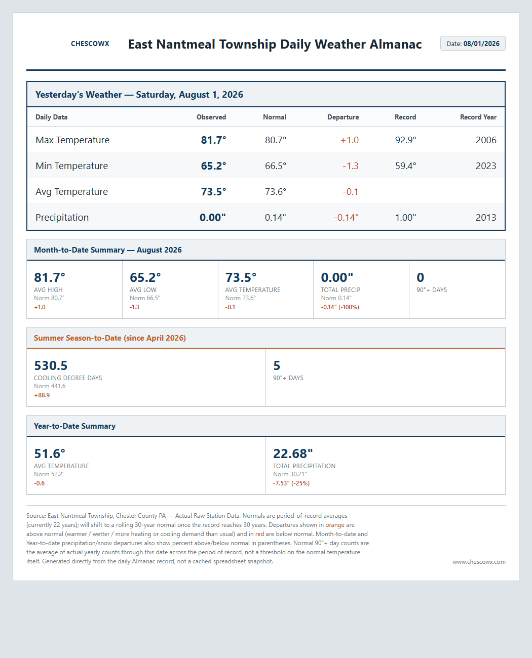
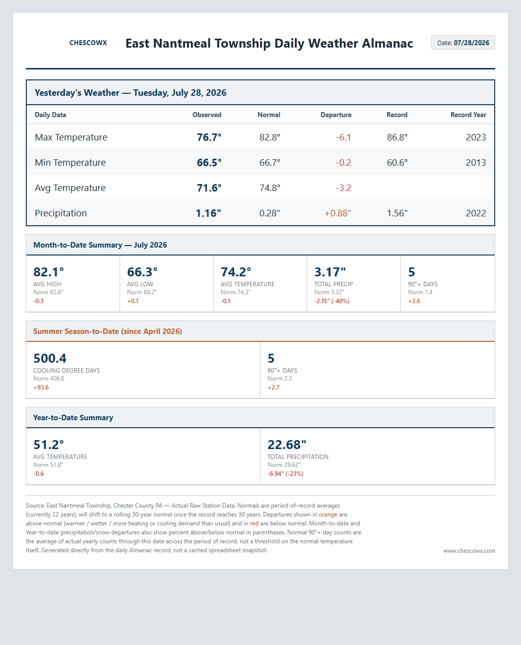
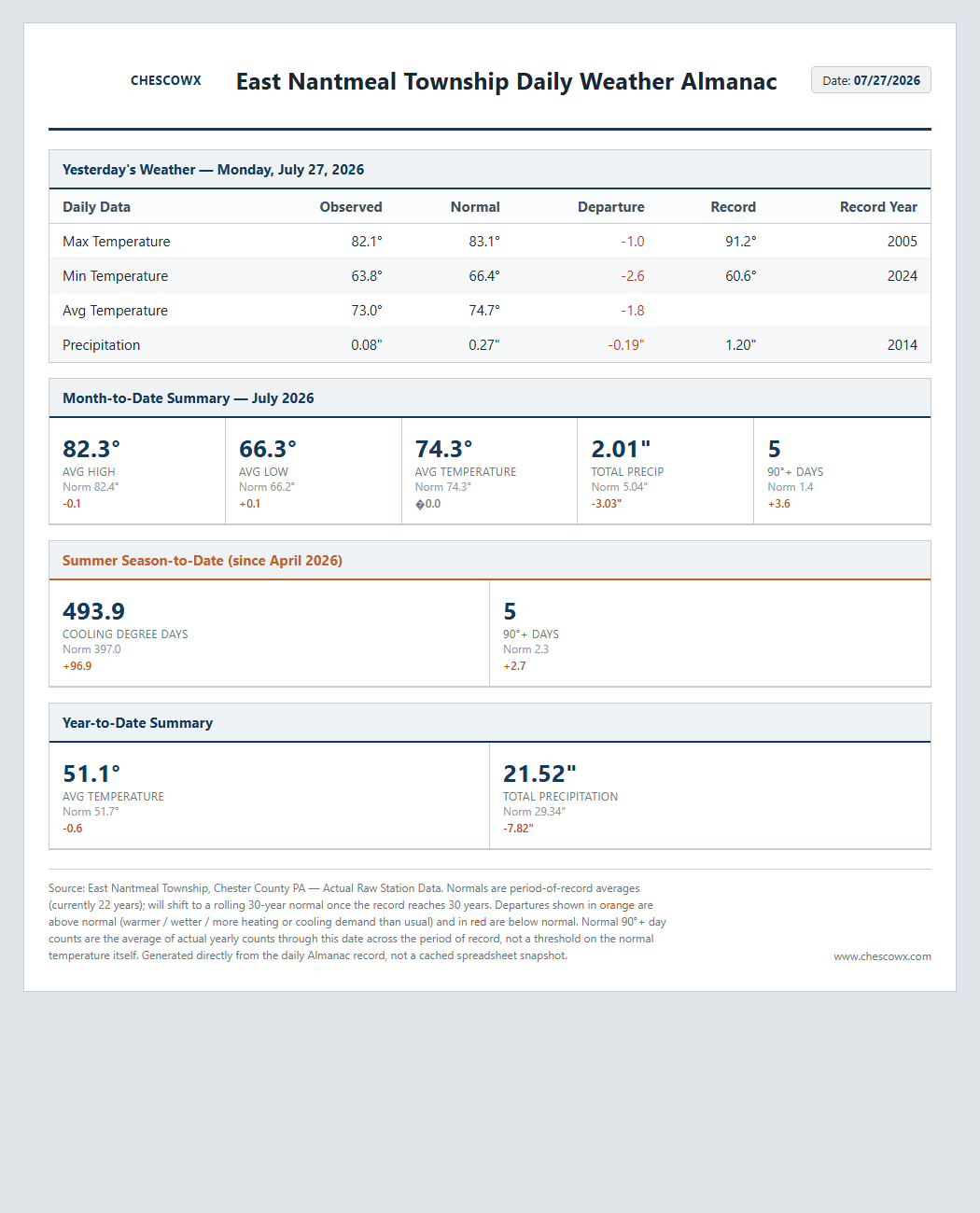
Here in East Nantmeal July finished with a slight 0.3 below normal average temperature for the month. This was the 4th below average month across our first 7 months of 2026. I will have the Chester County wide month summary later today. We turn a bit more humid today with rain chances again increasing by tomorrow night and lasting through much of the upcoming work week. No total washouts but a chance at some much-needed rainfall for areas who missed the beneficial rains last week.

-
E PA/NJ/DE Summer 2026 Obs/Discussion
ChescoWx replied to PhiEaglesfan712's topic in Philadelphia Region
Here in East Nantmeal July finished with a slight 0.3 below normal average temperature for the month. This was the 4th below average month across our first 7 months of 2026. I will have the Chester County wide month summary later today. We turn a bit more humid today with rain chances again increasing by tomorrow night and lasting through much of the upcoming work week. No total washouts but a chance at some much-needed rainfall for areas who missed the beneficial rains last week.
-
Central PA Summer 2026 Discussion/Obs Thread
ChescoWx replied to Voyager's topic in Upstate New York/Pennsylvania
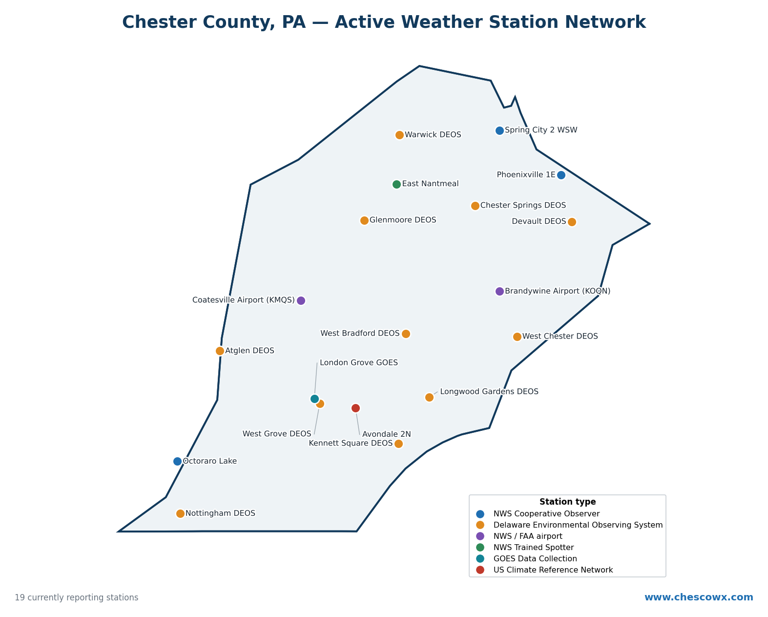
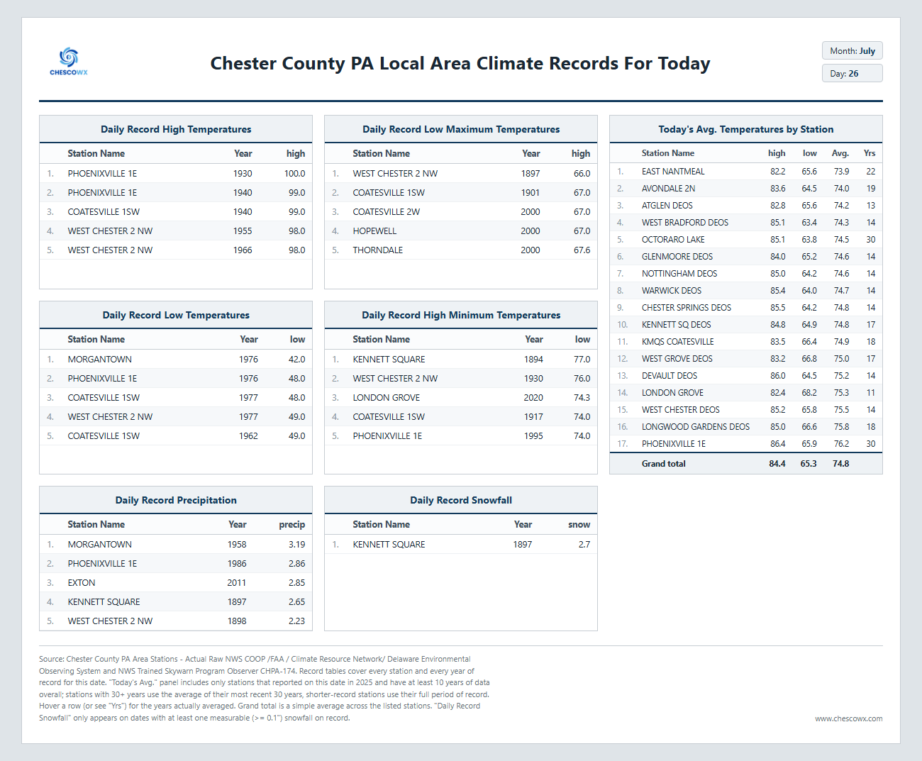
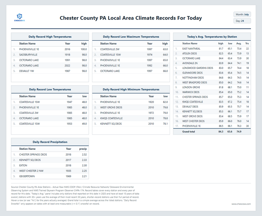
If anyone is interested in where the 19 current stations that feed our current active philly burbs of Chester County PA area weather data below is a map along with what type of station/reporter they have. Let me know if any questions. Thanks! There is also an interactive map with more detailed station detail that you can hover over on the ChescoWx website at https://chescowx.com/detailed-station-data/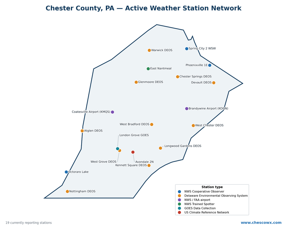
-
E PA/NJ/DE Summer 2026 Obs/Discussion
ChescoWx replied to PhiEaglesfan712's topic in Philadelphia Region
If anyone is interested in where the 19 current stations that feed our current active philly burbs of Chester County PA area weather data below is a map along with what type of station/reporter they have. Let me know if any questions. Thanks! There is also an interactive map with more detailed station detail that you can hover over on the ChescoWx website at https://chescowx.com/detailed-station-data/ https://on-data/@DrewForecast
-
You limited your local review to only 3 chesco stations - My review with AI had more local stations than you including Sadsbury, Devault 1W, Kennett Square and Morgantown- I focused on only local stations in or on the immediate borders of chesco like Morgantown/Elverson to better identify if there is any actual support based on the raw data that was able to identify if any significant drifts occurred at any stations near Coatesville 1SW to suppor the NCEI chilling adjustments. The statistical analysis clearly does not support the NCEI adjustments for Coatesville 1SW
-
Central PA Summer 2026 Discussion/Obs Thread
ChescoWx replied to Voyager's topic in Upstate New York/Pennsylvania
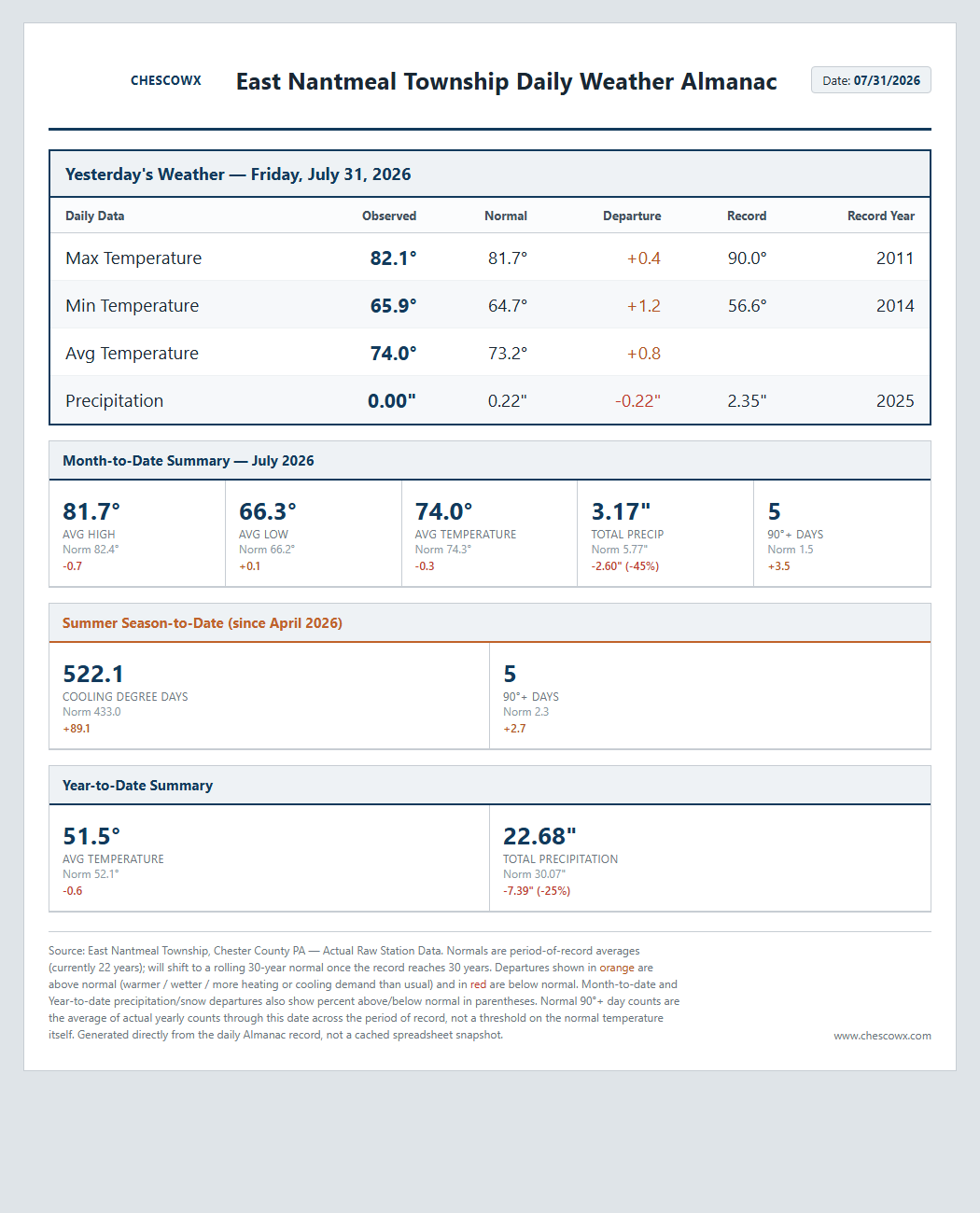
Our great weather continues with temperatures not far from normal as we close out July and move into August. Our next rain chances start to increase by Sunday.
-
E PA/NJ/DE Summer 2026 Obs/Discussion
ChescoWx replied to PhiEaglesfan712's topic in Philadelphia Region
Our great weather continues with temperatures not far from normal as we close out July and move into August. Our next rain chances start to increase by Sunday.
-
Central PA Summer 2026 Discussion/Obs Thread
ChescoWx replied to Voyager's topic in Upstate New York/Pennsylvania
Our weather has trended nicer for much of the rest of the work week with below normal temperatures continuing through the period. OUr next rain chances look to arrive later Sunday and into the start of the new work week.

-
E PA/NJ/DE Summer 2026 Obs/Discussion
ChescoWx replied to PhiEaglesfan712's topic in Philadelphia Region
Our weather has trended nicer for much of the rest of the work week with below normal temperatures continuing through the period. OUr next rain chances look to arrive later Sunday and into the start of the new work week.
-
Hi Don, I made no references at all to NCEI adjustments - the program identified the NCEI adjusted data. I had it review the NCEI adjustment criteria and assess based on those thresholds how the actual vs raw data surrounding changes for either TOB or site moves matched the critiera established by NCEI based on the adjustment papers.
-
Central PA Summer 2026 Discussion/Obs Thread
ChescoWx replied to Voyager's topic in Upstate New York/Pennsylvania
Despite our hot start to July we have turned much cooler over the last 10 days, which has brought us all the way back to average temperatures so far for the month of July. Today looks to be the most impactful day with flash flood threats although as many of you know much of Northern Chesco has not seen as much beneficial rains as the rest of the area. Shower chances will continue but not a wash out by any means through Thursday. We finally dry out on Friday with sun returning both Friday and Saturday.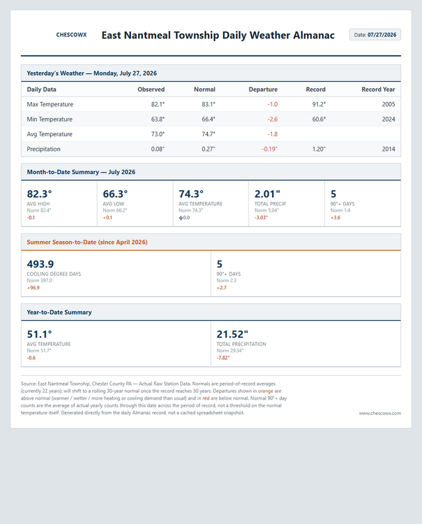

-
E PA/NJ/DE Summer 2026 Obs/Discussion
ChescoWx replied to PhiEaglesfan712's topic in Philadelphia Region
Despite our hot start to July we have turned much cooler over the last 10 days, which has brought us all the way back to average temperatures so far for the month of July. Today looks to be the most impactful day with flash flood threats although as many of you know much of Northern Chesco has not seen as much beneficial rains as the rest of the area. Shower chances will continue but not a wash out by any means through Thursday. We finally dry out on Friday with sun returning both Friday and Saturday.
-
Thanks Charlie! Much more to come with more area stations to support the raw data.
-
@chubbs below is some more detailed research and some solid evidence below to find if the single station NCEI applied cooling adjustments to Coatesville 1SW are supported by surrounding stations. For site moves and TOB changes. The final finding is that the clean evidence points to a real, still-unexplained cooling signal during at least the 1952-1982 portion of this period -- not caused by a location move or TOB change (neither was validated), Also Station relocation, across the 88-year period with usable NCEI-adjusted data (1895-1982) spanning the station's six relocations, never shows up as an independent, validated driver of any adjustment on its own. Once the confounded stations are set aside, the clean evidence actually points toward a real, unexplained cooling trend during at least the 1952-1982 portion of that period — just not one caused by a location move or TOB change. Take a look at the below and let me know what this analysis is missing? This is only for Coatesville 1SW raw vs the NCEI adjusted for that individual station. Based on this I will look to see if the other NCEI station adjustments to the raw data are valid and supported by the data. I have much more supporting data so feel free to ask and I will provide more data. Coatesville 1SW: Overall Testing Approach and Findings Overall Testing Approach 1. Pulled Coatesville 1SW's exact location and observation-time history from NCEI's HOMR database -- six site relocations and five distinct observation-schedule eras spanning 1888-1982, independently verified against the live HOMR page and a user-provided satellite image of the final site. 2. Initially tested using NCEI's own adjustment as the yardstick (comparing how the adjustment changed before/after each documented event). This is where standard time-of-observation-bias (TOB) theory first looked promising, then broke down: an all-morning schedule (1946-1982) should need little or no adjustment under TOB theory, not the sustained cooling actually applied. 3. Switched to raw-data-only testing -- the methodologically correct approach, since testing against NCEI's own output can't establish whether that output was justified in the first place. For each of Coatesville's 7 documented events, compared Coatesville's raw record against every available nearby raw-data station in clean, non-overlapping before/after windows. 4. Required cross-validation across independent references -- an event only counted as a real, validated discontinuity if multiple neighbor stations agreed on the direction of the shift, not just one. This is the key filter separating genuine breaks from ordinary weather noise. Expanded from 2 to up to 4 reference stations (West Chester 2 NW, Phoenixville 1E, Kennett Square, Sadsburyville) depending on era. 5. Result: only 3 of 7 documented events passed. 1916, 1922, and 1946 showed real, multi-station-confirmed shifts. 1902, 1910, 1930, and 1948 did not -- either unconfirmable (no second reference available) or references actively disagreeing (the signature of noise, not a real break). 6. Built a raw-justified adjustment chain using only those 3 validated steps, anchored to the stable, unchanged 1946-1982 era as a zero baseline, and compared it decade-by-decade against NCEI's actual adjustment, with formal significance testing at each step. Overall Finding NCEI's adjustment ran colder than the raw evidence supports in every single decade from the 1890s through the 1980s, with no exceptions. Restricting to the 8 complete decades (1900s-1970s), 6 of 8 reach conventional statistical significance (1900s, 1910s, 1930s, 1940s, 1950s, 1960s); the other two (1920s, 1970s) don't reach significance individually but still point the same direction. Pooled across all 88 years, the effect is overwhelming (p < 0.0001). The size of the over-cooling does not trend over time -- it is a persistent, roughly steady bias, not something that worsened or improved across the record. See "Raw vs NCEI vs Corrected Trend" for the full year-by-year data, decade table, and significance tests. Adjustment Broken Out by Rationale (all 7 documented events) Of NCEI's stated PHA rationale categories, only station relocation and observation-time change could be directly tested here. Only 3 of the 7 documented events show real, cross-validated evidence. Event Rationale Category Validated? Contribution to the Adjustment Chain 1902 Location move No -- single reference, unconfirmable 0 (no independent step; folded into the 1902-1915 era) 1910 TOB change No -- 2 references disagree in direction 0 (no independent step; folded into the 1902-1915 era) 1916 Location move + TOB shift (simultaneous) Yes -- 4 references agree +0.36°F, partially OFFSETTING (applies to 1902-1915 only; can't attribute to either cause alone) 1922 TOB change (location unchanged) Yes -- 3 references agree -1.28°F, the entire step applied to 1922-1945 1930 Location move No -- 2 references disagree in direction 0 (no step between 1922-1945 and 1946-1982) 1946 TOB change (location unchanged) Yes -- 2 references agree (thin sample) Combined with 1922: the entire -2.11°F applied to 1916-1921 1948 Location move No -- 2 references disagree in direction 0 (1946-1982 treated as one continuous baseline era) PRACTICAL ANSWER: of all 7 documented events, only 3 (1916, 1922, 1946) show real, cross-validated raw discontinuities -- 2 of those 3 (1922, 1946) are TOB changes with no location change; the third (1916) is an inseparable combined event. The 4 location-related events (1902, 1910, 1930, 1948) show no validated evidence at all. Station relocation, across the 88-year period with usable NCEI-adjusted data (1895-1982) spanning the station's six relocations, never shows up as an independent, validated driver of any adjustment on its own. Important: What "TOB" Explains Here, and What It Does Not The "TOB" label in the table above explains why the RECONSTRUCTED adjustment chain steps DOWN between eras (e.g. why 1922-1945 sits 1.28°F below the 1946-1982 baseline) -- it describes validated ONE-TIME transitions in Coatesville's own raw record relative to its neighbors. It does NOT mean TOB explains or justifies NCEI's actual, continued adjustment behavior within any era, including 1946-1982. If anything, classic TOB theory says a single MORNING reading (used throughout 1946-1982) should need a mild WARMING correction, not the sustained cooling NCEI actually applied that whole period (-0.82°F in the 1950s down to -0.21°F in the 1980s). That makes NCEI's continued cooling during 1946-1982 LESS justified under TOB theory, not more -- see "No Basis Found for Any Cooling Adjustment During 1946-1982" below, which is a separate, additional finding from the step-transition analysis above, not an extension of it. Important Caveat: What "Corrected" Does and Does Not Establish The "Corrected" series treats the 1946-1982 era as a zero-adjustment baseline because it is the final, most stable era with no further validated events. This is a standard homogenization convention (adjust the past to match the present), but it is NOT the same as proving 1946-1982 is itself free of bias. Under classic TOB theory, a single MORNING reading (used throughout 1946-1982) should carry a mild COLD bias, not be bias-free -- meaning the true fully-corrected record might need the entire chain shifted warmer, including the baseline era, which would make the required cooling for the earlier eras SMALLER than calculated here, not larger. This analysis establishes the RELATIVE size of each validated step; it does not establish an absolute, bias-free zero point. No Basis Found for Any Cooling Adjustment During 1946-1982 Separately from the baseline-anchoring question above, a cleaner and more direct claim: within the 1946-1982 period itself, location and observation schedule were BOTH stable throughout (no validated events of either kind). An additional check for undetected drift WITHIN this period (not just at its boundaries), using every available overlapping reference station, found no consistent evidence either: Devault 1W and Morgantown each show a significant COOLING drift relative to Coatesville (-1.15 and -0.26 F/decade), while West Chester 2 NW shows a significant WARMING drift in the OPPOSITE direction (+0.52 F/decade), and Phoenixville 1E shows no significant drift at all. By the same cross-validation standard used throughout this investigation, this disagreement means no validated drift exists either. CONCLUSION: with no validated location change, no validated TOB change, and no validated drift anywhere in this 36-year window, there is no raw-data basis found for ANY of NCEI's cooling adjustment during 1946-1982 -- not the varying decade-by-decade amounts NCEI actually applied (ranging from -0.82°F in the 1950s to -0.21°F in the 1980s), and not a flat adjustment either. This covers what could be directly tested here -- station moves and TOB, two of NCEI's four stated PHA rationale categories. No evidence of an undocumented instrument or land-use change was found either, but the available data could not specifically rule those out. Reference Station Confound Check (added later) The cross-validation method above assumed the reference stations (West Chester 2 NW, Phoenixville 1E, Kennett Square, Sadsburyville, Devault 1W, Morgantown) were themselves stable during the windows used to test Coatesville. Checking each one's own HOMR history directly found this was not fully true. Reference Station Own HOMR History Confound Found? West Chester 2 NW Moved slightly in early 1921; further moves in 1936, 1955, 1970, 1998, 2009, 2016 YES -- 1921 move overlaps the 1922 test's "before" window (1918-1921); 1955/1970 moves fall inside the 1946-1982 interior-drift window Phoenixville 1E Stable 1915 to 1948-05-01, then moved PARTIAL -- clean for 1922/1930/1946; its 1948 move falls inside the 1946-1982 interior-drift window Kennett Square Moved between 1916-11-30 and 1919-01-01 YES -- overlaps the 1916 test's "after" window (1917-1920) Sadsburyville Single location, entire 1910-1922 operating life None -- clean Devault 1W Single location, entire 1951-1989 operating life None -- clean Morgantown Single location, entire 1951-1987 operating life None -- clean REVISED CONCLUSIONS: (1) The 1916 finding still holds -- Sadsburyville (fully clean) and West Chester (clean for this specific window) both independently confirm it; only 1 of its 4 supporting references (Kennett Square) has a confound. (2) The 1946 finding is unaffected -- both its supporting references were stable throughout that specific window. (3) The 1922 finding is WEAKER than originally presented: it only ever had 2 supporting references, and the West Chester one is now known to be confounded by West Chester's own 1921 move. Phoenixville alone remains clean and still shows the same direction, but that is one clean reference, not the two-station cross-validation required elsewhere in this analysis -- treat 1922 as a lower-confidence, single-reference finding, not a fully cross-validated one. (4) MOST IMPORTANTLY, this partially reverses the "No Basis Found for Any Cooling Adjustment During 1946-1982" conclusion above: the earlier interior-drift check found 4 references disagreeing and read that as noise, but 2 of those 4 (West Chester, Phoenixville) turned out to have their own undocumented moves inside that exact window, while the 2 clean references (Devault 1W, Morgantown) both agreed on a real cooling drift (-1.15 and -0.26 F/decade). Once the confounded stations are set aside, the clean evidence points to a real, still-unexplained cooling signal during at least the 1952-1982 portion of this period -- not caused by a location move or TOB change (neither was validated), but a genuine physical signal nonetheless, not simply noise as previously stated.
-
Central PA Summer 2026 Discussion/Obs Thread
ChescoWx replied to Voyager's topic in Upstate New York/Pennsylvania
One last great weather day before we turned unsettled and wet for a good part of the upcoming work week. Hopefully, most of us see some rain as many spots, especially across Northern Chester County missed the rains last week. Below normal temperatures look to continue all week but with increasing humidity with the rain. The sun looks to it will return by Friday. Note: below on the climate records there is an errant snow report in the data set that is being corrected.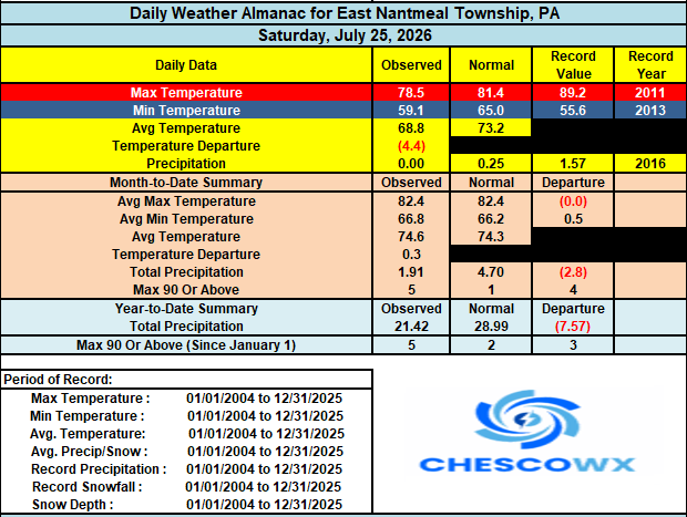

-
E PA/NJ/DE Summer 2026 Obs/Discussion
ChescoWx replied to PhiEaglesfan712's topic in Philadelphia Region
One last great weather day before we turned unsettled and wet for a good part of the upcoming work week. Hopefully, most of us see some rain as many spots, especially across Northern Chester County missed the rains last week. Below normal temperatures look to continue all week but with increasing humidity with the rain. The sun looks to it will return by Friday. Note: below on the climate records there is an errant snow report in the data set that is being corrected.
-
@chubbs you didn't answer my previous post "The problem that NCEI and Charlie has is that in reality Coatesville was home to Lukens Steel — a continuously operating steel mill since 1810, one of the largest specialty steel producers in the country, still headquartered there through 1982 and beyond this is a station within a mile of significant industrial activity! This of course is a textbook candidate for a persistent local warm bias — waste heat, paved/industrial surfaces, altered local airflow. But here's the problem for NCEI and Charlie to address - the Coatesville 1SW move explanation doesn't match the data adjustments made by NCEI. The facts are that Lukens was arguably at its industrial peak in the postwar decades (1946–82) — yet that's exactly the period where the adjustment (and the residual) is smallest, not largest. If growing industrial heat were the main driver, the bias should have gotten worse over the 20th century, not better. So it is not TOB adjustments and clearly not site moves behind these adjustments so what say you Charlie?
-
Central PA Summer 2026 Discussion/Obs Thread
ChescoWx replied to Voyager's topic in Upstate New York/Pennsylvania
Another chilly start for much of the area again today with the Warwick DEOS as low as 48.6 degrees this AM. A great weather weekend on the way with highs from the upper 70's to low 80's and lows in the 50's to low 60's. Rain chances look to increase both Monday and Tuesday - there could be some heavy rain chances for the area.
-
E PA/NJ/DE Summer 2026 Obs/Discussion
ChescoWx replied to PhiEaglesfan712's topic in Philadelphia Region
Another chilly start for much of the area again today with the Warwick DEOS as low as 48.6 degrees this AM. A great weather weekend on the way with highs from the upper 70's to low 80's and lows in the 50's to low 60's. Rain chances look to increase both Monday and Tuesday - there could be some heavy rain chances for the area.
-
Don you may want to look at my last post and help answer these gaps or as you call them "breakpoints" on why on a single station basis with rigorous long term station data such as Coatesville 1SW the annual supporting data from raw to adjusted for 99.7% of years from 1895 through 1971 was chilled by NCEI. We can see it is certainly not TOB and not site moves so what is it and why can't we quantify it if the science is so transparent by year with attribution to all of the potential reasons for chilling the data basically every single year for this station. Where is the NCEI detailed file explaining this particular stations unique adjustments by year?