-
Posts
8,486 -
Joined
Content Type
Profiles
Blogs
Forums
American Weather
Media Demo
Store
Gallery
Posts posted by Juliancolton
-
-
9 minutes ago, IrishRob17 said:
The Euro looked like I may have got a touch colder? I didn't dive into it though. My pack is bullet proof....
It did although still not great. This could be a snow profile with strong enough precip rates, which we don't really get on that run. A little elevation will help prolong the frozen, as you expect this time of year.

-
 1
1
-
-
It's already gone.

-
 2
2
-
-
17 minutes ago, CPcantmeasuresnow said:
I'd have to go with bad.
Of course this time of year, when according to some the sun angle can roast a medium sized turkey in under an hour, it's even worse.
At least we haven't gotten the extra hour of sun from DST yet

-
 2
2
-
 2
2
-
-
So I need a quick refresher. Soaking rain in the morning followed by full sun and temps racing toward 50... good for the pack or bad?
-
17 hours ago, wishcast_hater said:
What's the story with Friday/Saturday threat? The Metro forum isnt discussing which leads me to believe its a non event.
Looks pretty sloppy and uneventful for us, unless the GFS pulls a clean coup vs. most other guidance. I'm still interested, but not holding my breath.
-
 2
2
-
-
1 minute ago, LibertyBell said:
You can also have a KU event for an individual location, which I would say has to be 10" or more.
For example, a 10" event for Long Beach is a KU for Long Beach.
20" is HECS, so a 20" storm for Long Beach is an HECS for Long Beach.
Not really. NESIS (now RSI) was the basis for the KU canon, and that scale was specifically designed to capture the breadth of societal impacts. You can have a historic snowfall in one city over another, but a KU needs the regional extent by definition.
-
 2
2
-
-
GFS and RGEM look pretty great for Friday night. I'm in.
Looking at soundings, the GFS is actually all snow imby. That would be a nice hit.
-
 5
5
-
-
Still spitting snow grains here too. To keep an earlier promise: it would have been nice to get some accumulating rates during daylight hours.
-
 2
2
-
-
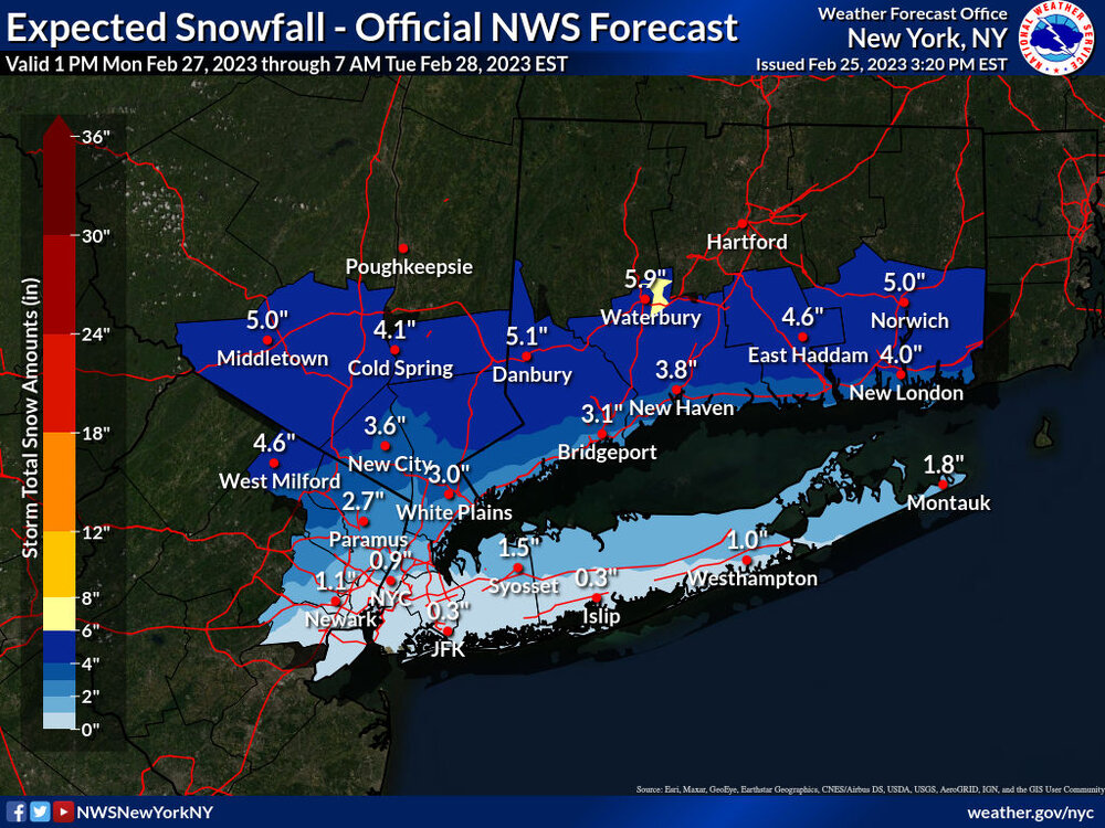
So 4.7" was my peak new depth as far as I'm aware. Waiting on the Stratus to melt out for LE. Pretty much AWT totals across the board except for the northern metro doing a bit better than I expected.
-
4.6" at home
-
9 minutes ago, dmillz25 said:
Getting thundersnow here in NYC
Snowstorms are so dramatic these days.
-
 3
3
-
-
Same current conditions as @gravityloverand same festivities as @sn0w. Glad we could do this at least once before spring.
Trying to decide on a location for tomorrow's sunrise hike. I've had Storm King on my mind for days, but that million car pileup on 9W is testing my nerve a little...
-
 2
2
-
 1
1
-
-
22 minutes ago, LibertyBell said:
Damn it! I heard there was a big solar storm!
Were they visible in the Southern Poconos south of I-80 do you know?
I assume so. This is apparently in extreme southern OH at 38.5N:
-
 1
1
-
 1
1
-
-
The northern lights were visible at least as far south as the Catskills and Poconos last night. I slept through it, naturally.
https://www.instagram.com/p/CpK8gUfMmt3/?igshid=YmMyMTA2M2Y=
-
 2
2
-
-
37 minutes ago, White Gorilla said:
I will take my 4-6 inches like a good boy and not complain.
I'll take it *and* complain. I can walk and chew gum.
-
 7
7
-
-
1 minute ago, CPcantmeasuresnow said:
I don’t quite understand the Winter Storm Watch for 5-8 still in Orange County. If they are so on the fence about achieving the six inch warning criteria why not just issue an advisory for 4-6 and upgrade to a warning at 4 am if needed.
It would be hard to blame them for grading on a curve. This is, after all, the first widespread significant event of the season, with all the heightened impacts that come with that.
-
Downslope purgatory incoming

-
 2
2
-
-
5 hours ago, LibertyBell said:
I've never been to Central Park and never plan on ever going there. I hate the place.
This is one of the greatest things I've ever read. Just an all-time great. Monuments will be erected in its honor.
-
 2
2
-
 7
7
-
-
3 hours ago, hudsonvalley21 said:
That's a solid map I think. The initial overrunning stage looks juicy enough, but assume climo ratios or slightly worse, given mediocre snow growth soundings throughout. Nothing wrong at all with a 4-6" deal.
-
 3
3
-
-
Getting brighter here after 1.3"
-
 2
2
-
-
45 minutes ago, BxEngine said:
Gonna end up with an inch of fluff.
Approaching an inch here too. It's like a clipper from yesteryear.
-
 2
2
-
-
4 minutes ago, Will - Rutgers said:
thought i saw some lightning today but it was just the knife i stuck in the electrical socket
Positive or negative strike?
-
GFS now flips us all to sleet for a short time on Tuesday. Quickly running out of wiggle room.
-
3 hours ago, gravitylover said:
That little bit of sleet coating yesterday didn't prove to be terribly resistant
 It feels so late March/early April outside right now. Blah... Some of those 20"+ panels everyone's posting are making me wonder, real or fantasy? At this point I don't want it, time to move on. That doesn't mean I won't stand out there, shovel in hand, at 1am enjoying it
It's a shame we couldn't get some of that warm front action today. At least a few runs earlier in the week had highs near 60. Instead, crap.


Interior NW & NE Burbs 2023
in New York City Metro
Posted
These hyper-amped extended range signals always seem to cut. Not getting the warm fuzzies yet about next week.