

snowfan
-
Posts
9,061 -
Joined
-
Last visited
Content Type
Profiles
Blogs
Forums
American Weather
Media Demo
Store
Gallery
Posts posted by snowfan
-
-
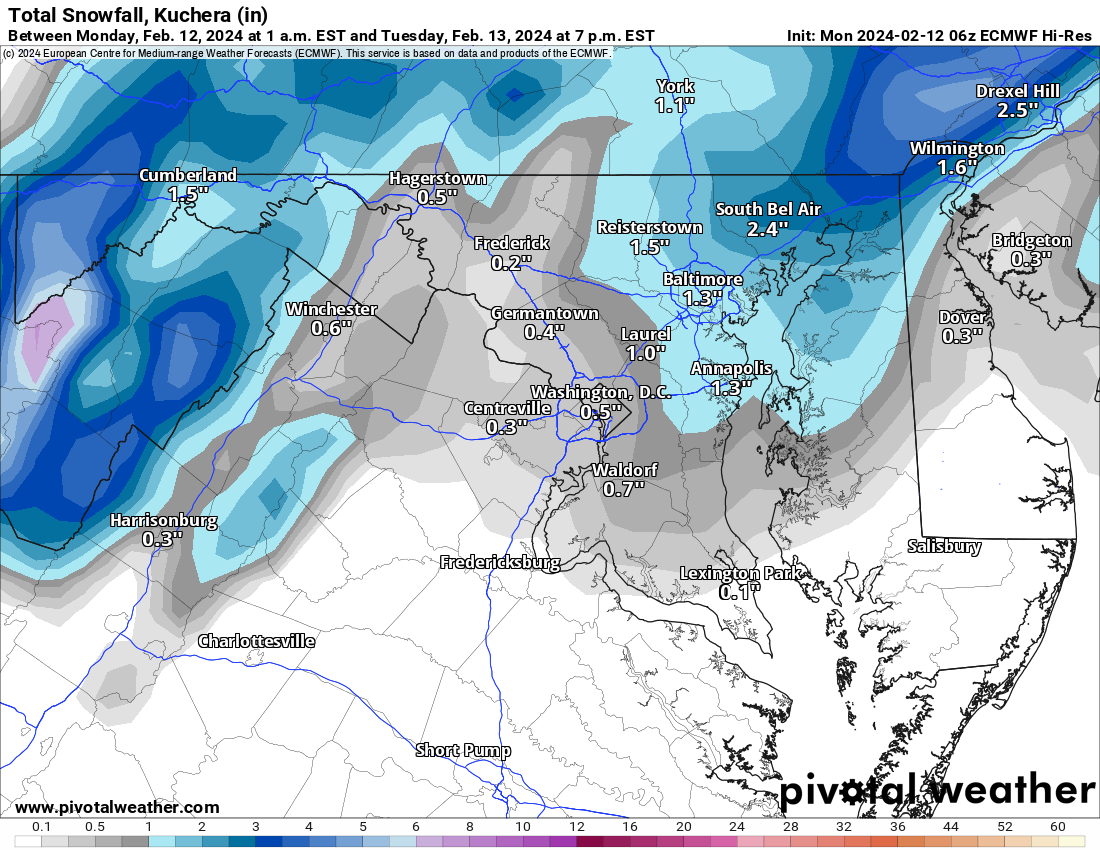
CWGs 9th update of the day calls for up to an inch or so in the colder areas.
-
 2
2
-
 5
5
-
-
4 minutes ago, rjvanals said:
Foreshadowing this thread in ~10 hours
No doubt. This feels like one of those events where late excitement builds and then…..THUD.
-
1
-
-
Viewer discretion advised in the New England sub.
-
1
-
5
-
-
1 minute ago, stormtracker said:
Bit more...amp'd so far...trajectory of the precip to our west bumped up north
Why do you hate us?
-
 1
1
-
-
Tighten it up in here. Randy will be here soon for critical NAM pbp.
-
1
-
-
1 minute ago, Ravens94 said:
Anyone have the 18z eps

-
2
-
-
2 minutes ago, clskinsfan said:
Where is the cold air coming from?

These systems generally create their own cold air. Duh.
-
1
-
-
24 minutes ago, stormtracker said:
In all seriousness, 0z runs tonight will probably be the highest anticipated runs so far this season.
Are you going to be sober for the pbp?
-
16 minutes ago, aldie 22 said:
It's raining

Snow can’t accumulate on wet ground.
-
Y’all living by the RAP are gonna be in bad shape tomorrow. Randy might need to put you in witness protection.
-
1
-
-
-
7am sounding on the euro for mappyland.

-
1
-
-
-
2
-
-
3k and 12k way different. Proceed w caution.


-
1
-
-
Weenies north of us jumping off buildings bc of the euro.
-
1
-
9
-
-
-
-
6 minutes ago, Storm Clouds said:
It’s beyond me why State College doesn’t even have a winter weather advisory yet for southern tern counties! Everyone model I see has at least 3-4 inches. People are going to be blindsided…
They addressed that area in their morning disco.
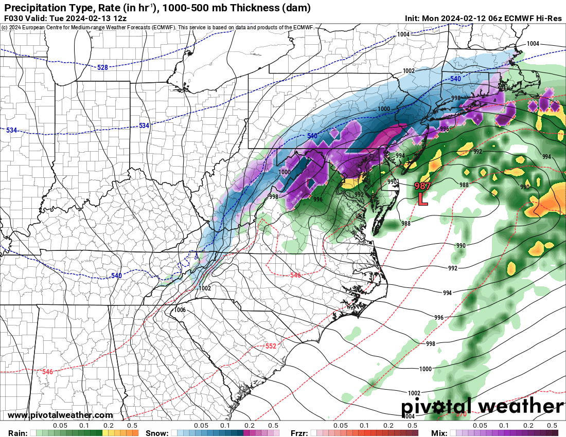
The SE will be the last to turn.
However, there is still some doubt/uncertainty as to the p-type
for the far SE (Adams, York, Lancaster) as the heaviest slug of
precip arrives in the early morning. If it falls hard enough,
it could be all snow as it won`t have time to warm up. However,
we could see another waggle back north, and this would keep the
temps just mild enough for a mix or just plain rain. SLRs
continue to look very low (sloppy, wet snow) for all of the
area. Extreme snowfall rates are possible. HREF progs support
high (90 pct chc) of 1-2"/hr snowfall rates over the central
zones, and even as far S as the Turnpike. That would make a big
mess for Harrisburg right when everyone is traveling. The
uncertainty of the band placement has kept us from converting
the Harrisburg metro into a warning at this point. We`ll ride
the watch.
-
7 hours ago, nj2va said:
I was staying in Asheville for the last eclipse and drove to Sylva, NC (short distance away) and traffic was crazy both in/out of the path of totality. Plan for busy roads day of if you’re driving that day.
Some in the New England sub have been discussing this. They’re expecting gridlock in NNE parts of NY/VT/NH.
-
Damn…what an ending.
-
2 hours ago, Scraff said:
Let’s go Chiefs! Fuck SF!! And now it’s the Super Bowl Fridge Index and it’s at an all time high today. Means nothing for snow apparently though.


Dude…you’re still rocking that street corn dip.
-
2
-
-
-
18z euro touching the M/D line with light accums.
-
Damn….that commercial cost Dunkin’ a pretty penny.


2024 Valentines Day Who the Hell Knows - Comeback Thread
in Mid Atlantic
Posted