north pgh
-
Posts
3,012 -
Joined
-
Last visited
Content Type
Profiles
Blogs
Forums
American Weather
Media Demo
Store
Gallery
Everything posted by north pgh
-

Western Pa / Pittsburgh area Winter Discussion ❄️☃️
north pgh replied to north pgh's topic in Upstate New York/Pennsylvania
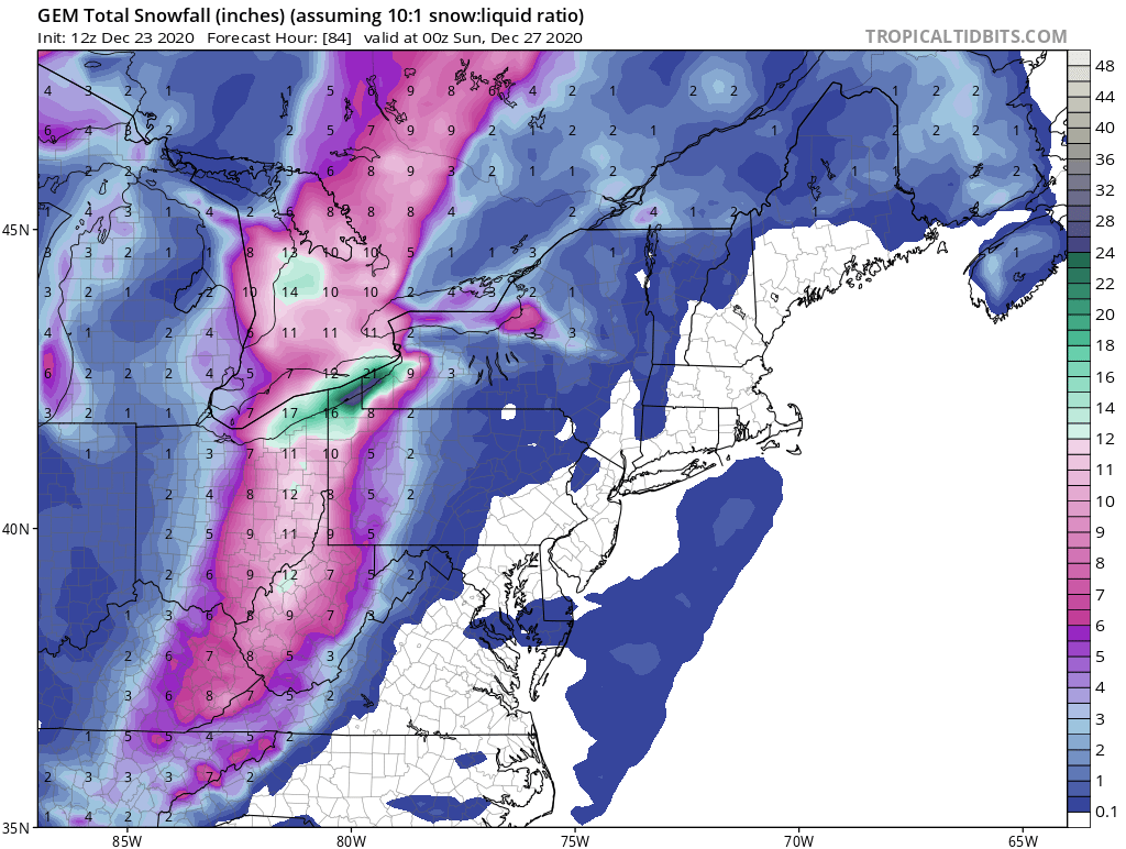
Wow Canadian! Merry Christmas!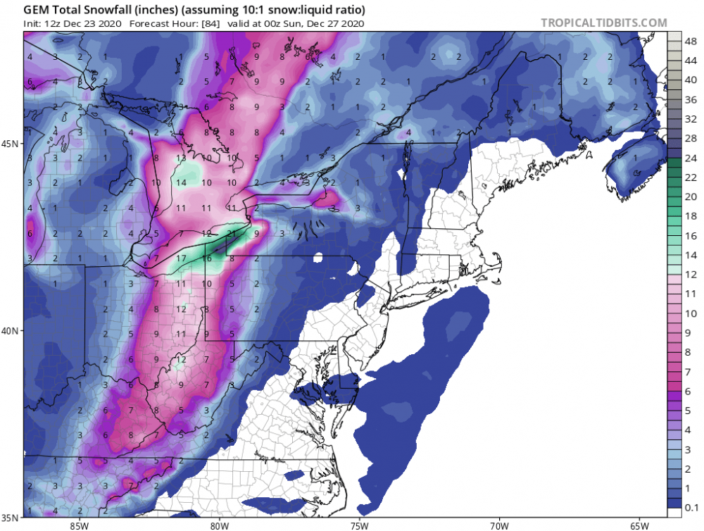
-
Western Pa / Pittsburgh area Winter Discussion ❄️☃️
north pgh replied to north pgh's topic in Upstate New York/Pennsylvania
Yes the Nam is picking up on this. Let's hope this is not a trend. -
Western Pa / Pittsburgh area Winter Discussion ❄️☃️
north pgh replied to north pgh's topic in Upstate New York/Pennsylvania
Where is everyone at? We are 2 days away from a possible 4+ inch snowfall on Christmas Eve. -
Western Pa / Pittsburgh area Winter Discussion ❄️☃️
north pgh replied to north pgh's topic in Upstate New York/Pennsylvania
Christmas Eve night.
-
Western Pa / Pittsburgh area Winter Discussion ❄️☃️
north pgh replied to north pgh's topic in Upstate New York/Pennsylvania
I think 3-6 is too high. More like 1-3 or 2-4. Would still take that in a heartbeat on Christmas Eve. -
Western Pa / Pittsburgh area Winter Discussion ❄️☃️
north pgh replied to north pgh's topic in Upstate New York/Pennsylvania
Christmas Eve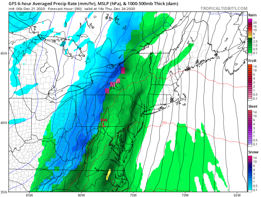
-
Western Pa / Pittsburgh area Winter Discussion ❄️☃️
north pgh replied to north pgh's topic in Upstate New York/Pennsylvania
I guess everyone slept in and missed it. A nice pasted 1.5 inches of heavy wet snow early this morning. A nice December so far. A 7 inch storm. A 10 inch storm and a surprise this morning. Almost 20 inches and it’s not Christmas yet. -
Western Pa / Pittsburgh area Winter Discussion ❄️☃️
north pgh replied to north pgh's topic in Upstate New York/Pennsylvania
Just woke up to heavy wet snow. A solid inch or so and still coming down. Nice surprise -
Western Pa / Pittsburgh area Winter Discussion ❄️☃️
north pgh replied to north pgh's topic in Upstate New York/Pennsylvania
Don't be surprised if we get a small snowfall on Saturday night Sunday morning. Yes Christmas eve looks good. Worst Case scenario we get the frontal system and back end snow showers Christmas eve. -
Western Pa / Pittsburgh area Winter Discussion ❄️☃️
north pgh replied to north pgh's topic in Upstate New York/Pennsylvania
Yes nice steady light snow. Putting down a coating on top the 10 we got yesterday. Beautiful -
Western Pa / Pittsburgh area Winter Discussion ❄️☃️
north pgh replied to north pgh's topic in Upstate New York/Pennsylvania
Tonight is the perfect night for a walk. 10 inches of snow on the ground and trees. Christmas lights shining bright. And a calm snow globe light snow falling. Can't beat it. This would be perfect weather for Christmas Eve. -
Western Pa / Pittsburgh area Winter Discussion ❄️☃️
north pgh replied to north pgh's topic in Upstate New York/Pennsylvania
10.5 here in Ross. This storm reminded me of the storms we had growing up back in the 1970’s. All day snow....not a lot of wind.....would play in it all day only coming in every 2 or 3 hours to warm up. With the Christmas lights as a backdrop too. It was very satisfying -
Western Pa / Pittsburgh area Winter Discussion ❄️☃️
north pgh replied to north pgh's topic in Upstate New York/Pennsylvania
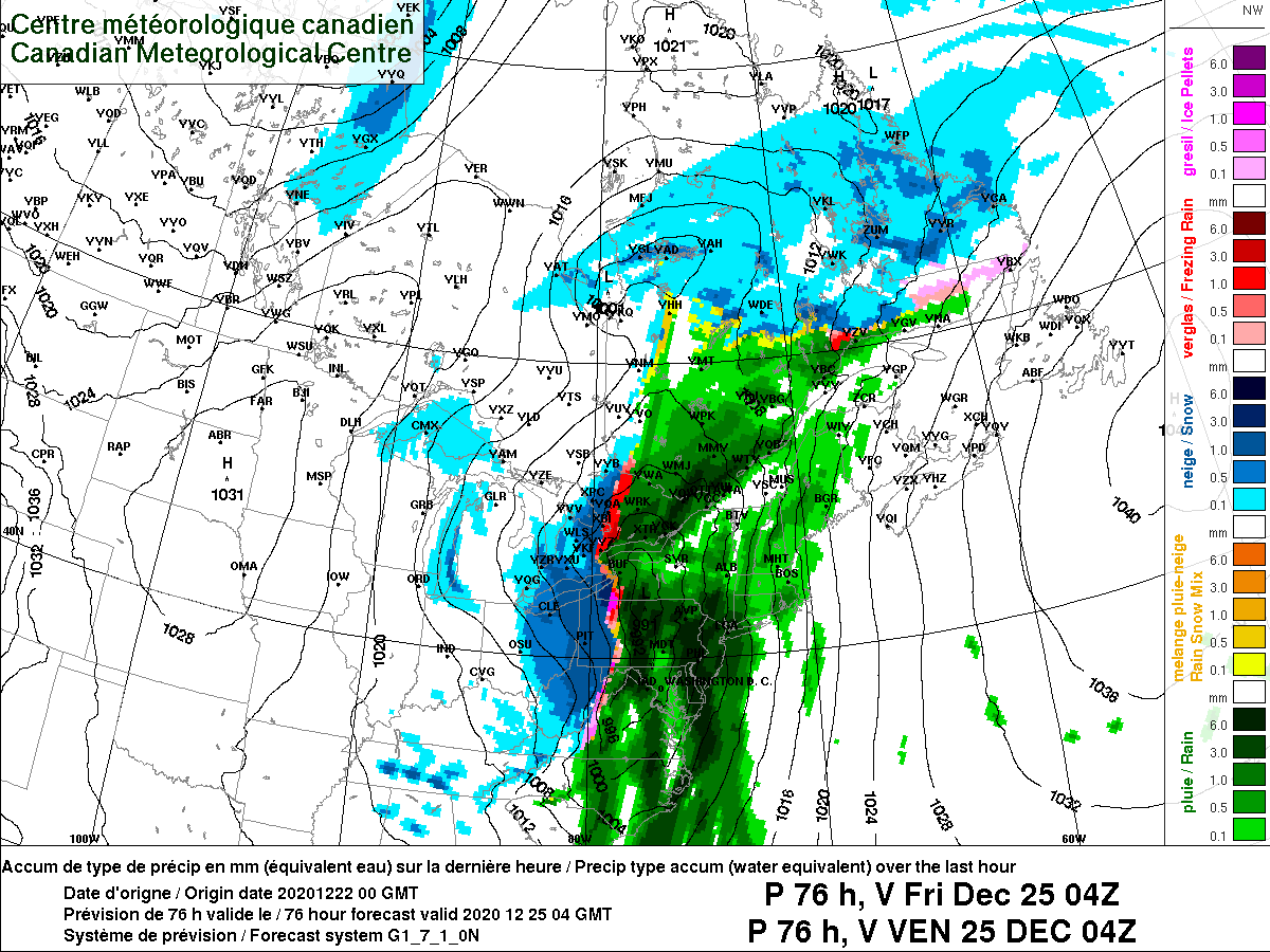
This was from yesterday morning. The Canadian has been my model of choice the last couple years. -
Western Pa / Pittsburgh area Winter Discussion ❄️☃️
north pgh replied to north pgh's topic in Upstate New York/Pennsylvania
9 inches here. Hope to make it to double figures. -
December 16 2020 CTP Snowstorm Disco and Obs
north pgh replied to pasnownut's topic in Upstate New York/Pennsylvania
7.5 so far here. -
Western Pa / Pittsburgh area Winter Discussion ❄️☃️
north pgh replied to north pgh's topic in Upstate New York/Pennsylvania
I just measured 7.5. Still coming down -
Western Pa / Pittsburgh area Winter Discussion ❄️☃️
north pgh replied to north pgh's topic in Upstate New York/Pennsylvania
You don't see this very often. The entire state of Pa REGIONAL WEATHER ROUNDUP NATIONAL WEATHER SERVICE STATE COLLEGE PA 600 PM EST WED DEC 16 2020 Note: "fair" indicates few or no clouds below 12,000 feet with no significant weather and/or obstructions to visibility. * = STATION THAT DOES NOT REPORT PRECIPITATION /E.G. RAIN...SNOW...ETC/ THUNDER OR FOG. PAZ002>004-007>009-013>016-020>023-029>032-170000- WESTERN PENNSYLVANIA CITY SKY/WX TMP DP RH WIND PRES REMARKS ERIE CLOUDY 31 22 69 VRB6 29.98F MEADVILLE LGT SNOW 25 22 88 E7 29.92S FOG FRANKLIN LGT SNOW 24 22 91 E8 29.92F FOG NEW CASTLE CLOUDY 27 25 92 NE5 29.92S FOG BEAVER COUNTY LGT SNOW 28 27 96 CALM 29.89R VSB 1 BUTLER LGT SNOW 26 24 92 E12G21 29.90F FOG PITTSBURGH INT HVY SNOW 29 27 92 E8 29.87F VSB 1/4 PITTSBURGH SNOW 30 29 96 E6 29.86F VSB 1/2 INDIANA* CLOUDY 27 27 100 E7 29.94F FOG LATROBE SNOW 28 27 93 E5 29.90F VSB 1/2 WASHINGTON CO* LGT SNOW 31 31 100 NE5 29.89F FOG $$ PAZ004>006-010>012-017>019-024>028-033>037-041-042-045-046-049>053-170000- CENTRAL PENNSYLVANIA CITY SKY/WX TMP DP RH WIND PRES REMARKS BRADFORD LGT SNOW 23 17 78 E10 29.94F VSB 3/4 WCI 12 ST MARYS LGT SNOW 21 19 93 E7 29.97F VSB 3/4 WCI 13 DUBOIS SNOW 22 19 89 E9 29.91F VSB 1/2 WCI 12 CLEARFIELD HVY SNOW 21 18 88 NE10 29.95F VSB 1/4 WCI 10 JOHNSTOWN LGT SNOW 22 19 89 NE10 29.83F VSB 3/4 WCI 11 SOMERSET LGT SNOW 21 19 93 NW6 29.87R WCI 14 ALTOONA HVY SNOW 23 19 85 N13 29.91F VSB 1/4 WCI 11 STATE COLLEGE HVY SNOW 21 19 93 NE15 29.98F VSB 1/4 WCI 8 REEDSVILLE SNOW 27 27 100 NE12 29.97F VSB 1/2 WELLSBORO LGT SNOW 18 18 100 NE7 30.00F VSB 3/4 WCI 8 WILLIAMSPORT HVY SNOW 25 22 88 NE5 30.05F VSB 1/4 SELINSGROVE HVY SNOW 25 24 96 N6 30.05F VSB 1/4 FT INDIANTOWN NOT AVBL CAPITAL CITY LGT SNOW 27 20 75 E14G22 29.98F HARRISBURG LGT SNOW 25 20 81 E9G18 29.97F VSB 3/4 YORK LGT SNOW 27 22 81 E17G25 29.93F WCI 14 $$ PAZ038>040-043-044-047-048-054-055-060>062-067>071-170000- EASTERN PENNSYLVANIA CITY SKY/WX TMP DP RH WIND PRES REMARKS TOWANDA N/A 21 19 93 NE13G18 30.12F VSB 3/4 WCI 9 SCRANTON SNOW 21 16 81 E8 30.09F VSB 1/2 WCI 11 MOUNT POCONO LGT SNOW 15 12 88 NE12G22 30.05F VSB 3/4 WCI 2 HAZLETON HVY SNOW 23 19 86 E9 30.04F VSB 1/4 WCI 13 LEHIGHTON SNOW 23 21 93 NE9G18 30.12F VSB 1/2 WCI 13 ALLENTOWN HVY SNOW 21 18 88 NE22 30.11F VSB 1/4 WCI 5 QN CITY/ALNTWN SNOW 23 21 93 NE15 30.11F VSB 1/2 WCI 10 QUAKERTOWN* FOG 23 23 100 NE13 30.06F VSB 1/4 WCI 11 PERKASIE* SNOW 23 23 100 NE16G24 30.06F VSB 1/2 WCI 10 DOYLESTOWN LGT SNOW 26 21 81 NE12G22 30.06F VSB 1 READING FOG 23 21 92 NE15 30.04F VSB 1/2 WCI 10 LANCASTER LGT SNOW 28 23 81 E18G29 29.97F COATESVILLE LGT SNOW 27 25 93 NE12G30 29.98F WEST CHESTER LGT SNOW 28 27 93 NE17G23 30.01F POTTSTOWN LGT SNOW 24 22 91 NE16G23 30.06F FOG WCI 11 BLUE BELL LGT SNOW 26 25 94 NE15G21 30.04F FOG WCI 14 NORTH PHILA LGT SNOW 30 28 92 NE21G30 30.07F FOG PHILADELPHIA LGTSLEET 31 28 89 NE22G37 30.02F $$ -
Western Pa / Pittsburgh area Winter Discussion ❄️☃️
north pgh replied to north pgh's topic in Upstate New York/Pennsylvania
I saw some briefly red returns on NWS Radar in this band. -
Western Pa / Pittsburgh area Winter Discussion ❄️☃️
north pgh replied to north pgh's topic in Upstate New York/Pennsylvania
3 inches measured here -
Western Pa / Pittsburgh area Winter Discussion ❄️☃️
north pgh replied to north pgh's topic in Upstate New York/Pennsylvania
That band is arriving here now. Remember we still have 9 more hours of snow falling at various rates. -
Western Pa / Pittsburgh area Winter Discussion ❄️☃️
north pgh replied to north pgh's topic in Upstate New York/Pennsylvania
Yes. It has been a couple years since we’ve had a daytime snowfall. It’s much more fun watching the snow fall then just waking up and having it on the ground. And we will also have steady snow moderate at times for the next 12 hours. -
Western Pa / Pittsburgh area Winter Discussion ❄️☃️
north pgh replied to north pgh's topic in Upstate New York/Pennsylvania
Another thing that we forget because we usually get nickeled and dimed is what decent snowfall rates look like. Already getting the larger flakes and it is also daytime too. usually it falls overnight and we can't even see it. -
Western Pa / Pittsburgh area Winter Discussion ❄️☃️
north pgh replied to north pgh's topic in Upstate New York/Pennsylvania
Just took a short walk with the dog. Snowing lightly here. The ground is frozen and hard so should start to accumulate quickly. I don't see any melting. Enjoy -
Western Pa / Pittsburgh area Winter Discussion ❄️☃️
north pgh replied to north pgh's topic in Upstate New York/Pennsylvania
I believe all that activity to our east is virga. No snow observations yet . According to radar we should be having snow any minute now in the south hills. Any confirmations yet? -
Western Pa / Pittsburgh area Winter Discussion ❄️☃️
north pgh replied to north pgh's topic in Upstate New York/Pennsylvania
Please.... we know already how disappointed you are. We do not need to see it posted 5 times an hour. If you want to keep complaining take it here.