

north pgh
-
Posts
3,012 -
Joined
-
Last visited
Content Type
Profiles
Blogs
Forums
American Weather
Media Demo
Store
Gallery
Everything posted by north pgh
-

Western Pa / Pittsburgh area Winter Discussion ❄️☃️
north pgh replied to north pgh's topic in Upstate New York/Pennsylvania
A solid 3 inches here and radar looks good. This morning I was thinking we were going to maybe underperform but now it looks like the opposite. Just to the northwest a nice swath or snow or some kind or deformation zone setting up and drifting south. -
Western Pa / Pittsburgh area Winter Discussion ❄️☃️
north pgh replied to north pgh's topic in Upstate New York/Pennsylvania
Was anyone else getting excited to see the Steelers Ravens play in the snow Tuesday? I was. Now moved to Wednesday. That Blows. We have not had snow for a home Steeler game in like 15 years. -
Western Pa / Pittsburgh area Winter Discussion ❄️☃️
north pgh replied to north pgh's topic in Upstate New York/Pennsylvania
Looks like something to watch next next Monday Tuesday. -
Let’s open the Winter discussions
-
Pittsburgh PA Spring and Summer 2020 Thread
north pgh replied to meatwad's topic in Upstate New York/Pennsylvania
Raise your hand if you are going to be on here tracking that snow storm this winter that we are so desperately due. -
Pittsburgh PA Spring and Summer 2020 Thread
north pgh replied to meatwad's topic in Upstate New York/Pennsylvania
We always talk about the Western Pa. screw jobs for snowstorms each Winter. Check out this Summer Thunderstorm screw job map.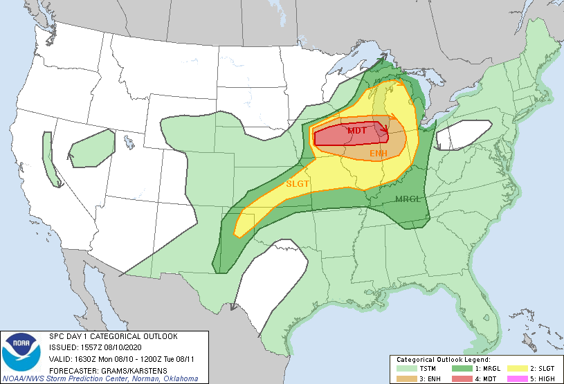
-
Pittsburgh PA Spring and Summer 2020 Thread
north pgh replied to meatwad's topic in Upstate New York/Pennsylvania
Boring Weather pattern here. In 3 months we will be getting ready to track winter storms. -
Pittsburgh PA Spring and Summer 2020 Thread
north pgh replied to meatwad's topic in Upstate New York/Pennsylvania
Right on schedule, models had this line falling apart as it gets here and low and behold it is...At least over North Central Alleg Co. -
Pittsburgh PA Spring and Summer 2020 Thread
north pgh replied to meatwad's topic in Upstate New York/Pennsylvania
Light Flurries in Ross. -
Pittsburgh PA Spring and Summer 2020 Thread
north pgh replied to meatwad's topic in Upstate New York/Pennsylvania
I hope I will be able wake up Saturday morning and take some historic pictures, even a inch on the trees would be nice. What a way to end a wacky 2020. I can just see some of the funny posts in the future such as .......... ” This winter has been bad For snow. I’m ready for spring” then someone can say “Don’t give up, remember last year we had that snow event in May” lol -
Pittsburgh PA Spring and Summer 2020 Thread
north pgh replied to meatwad's topic in Upstate New York/Pennsylvania
Be optimistic. 6 months from now we will be getting ready to track winter storms again. haha. Maybe 2020-2021 will be our year of the big snowstorm or 2 . We are due! -
Pittsburgh PA Spring and Summer 2020 Thread
north pgh replied to meatwad's topic in Upstate New York/Pennsylvania
Glad you’re ok. That wind was nasty. Our house was shaking. -
Pittsburgh PA Spring and Summer 2020 Thread
north pgh replied to meatwad's topic in Upstate New York/Pennsylvania
I'll give you this, for as bad as our Winter was snow wise.... We have made up for it with a stormy 2019 and so far in 2020. -
Pittsburgh PA Spring and Summer 2020 Thread
north pgh replied to meatwad's topic in Upstate New York/Pennsylvania
Not only are they fast moving but the wind did not go down after the gust front went through. Winds pretty much were sustained with high gusts for 10 to 15 minutes or so. I'm sure there were gusts over 50 in spots. -
Pittsburgh PA Spring and Summer 2020 Thread
north pgh replied to meatwad's topic in Upstate New York/Pennsylvania
Tornado warning for beaver County -
Pittsburgh PA Spring and Summer 2020 Thread
north pgh replied to meatwad's topic in Upstate New York/Pennsylvania
Allegheny County in the next hour will be next. -
Pittsburgh PA Spring and Summer 2020 Thread
north pgh replied to meatwad's topic in Upstate New York/Pennsylvania
I’ll be up waiting and watching. -
Pittsburgh PA Spring and Summer 2020 Thread
north pgh replied to meatwad's topic in Upstate New York/Pennsylvania
It looks like we could be getting some decent thunderstorms again Tuesday. Then for fun I just pulled this off the 12Z Canadian. -
Pittsburgh/Western PA Banter & Complaint Thread
north pgh replied to blackngoldrules's topic in Upstate New York/Pennsylvania
My current conditions 34 and The new winter normal. -
Pittsburgh/Western PA Banter & Complaint Thread
north pgh replied to blackngoldrules's topic in Upstate New York/Pennsylvania
I am cooking lasagna. Weather wise I feel like I’m watching a steeler game and we are 10 point favorites and we are down 21-3 in the first quarter. Ouch -
Pittsburgh/Western PA Banter & Complaint Thread
north pgh replied to blackngoldrules's topic in Upstate New York/Pennsylvania
I see Boston is under a winter storm watch for 8-12 inches of snow. It seems like they get at least 2 or 3 of these types of storms a year. Here in pitt anymore we have to wait 4 or 5 years for one! -
Pittsburgh/Western PA Banter & Complaint Thread
north pgh replied to blackngoldrules's topic in Upstate New York/Pennsylvania
A touchdown in pick up football, flag football, high school football, college football. A celebration and an exciting ending to an exciting game. In the NFL we have to pick the play apart frame by frame. Overrule it. Ruin an exciting ending to an exciting game. Sorry but let these guys play. Fan or not rules and replay has to change. Now let's get a damn snow storm!!!!!!! -
Pittsburgh/Western PA Banter & Complaint Thread
north pgh replied to blackngoldrules's topic in Upstate New York/Pennsylvania
**ck the NFL. The steelers were robbed. -
Pittsburgh/Western PA Banter & Complaint Thread
north pgh replied to blackngoldrules's topic in Upstate New York/Pennsylvania
I just had a trip up to Bradford and back today. Hit some nice squalls north of I-80 this afternoon. Bradford has about 6 inches on the ground. Just north of Clarion around Marienville they have close to a foot up through the Allegheny Forest. I guess that's where you need to be to get the snow this year and probably every year. -
Pittsburgh/Western PA Banter & Complaint Thread
north pgh replied to blackngoldrules's topic in Upstate New York/Pennsylvania
It sucks that the month of January was way above normal temp wise but also way above normal in precip. A lot of wasted January precip on rain.


