north pgh
-
Posts
3,012 -
Joined
-
Last visited
Content Type
Profiles
Blogs
Forums
American Weather
Media Demo
Store
Gallery
Everything posted by north pgh
-

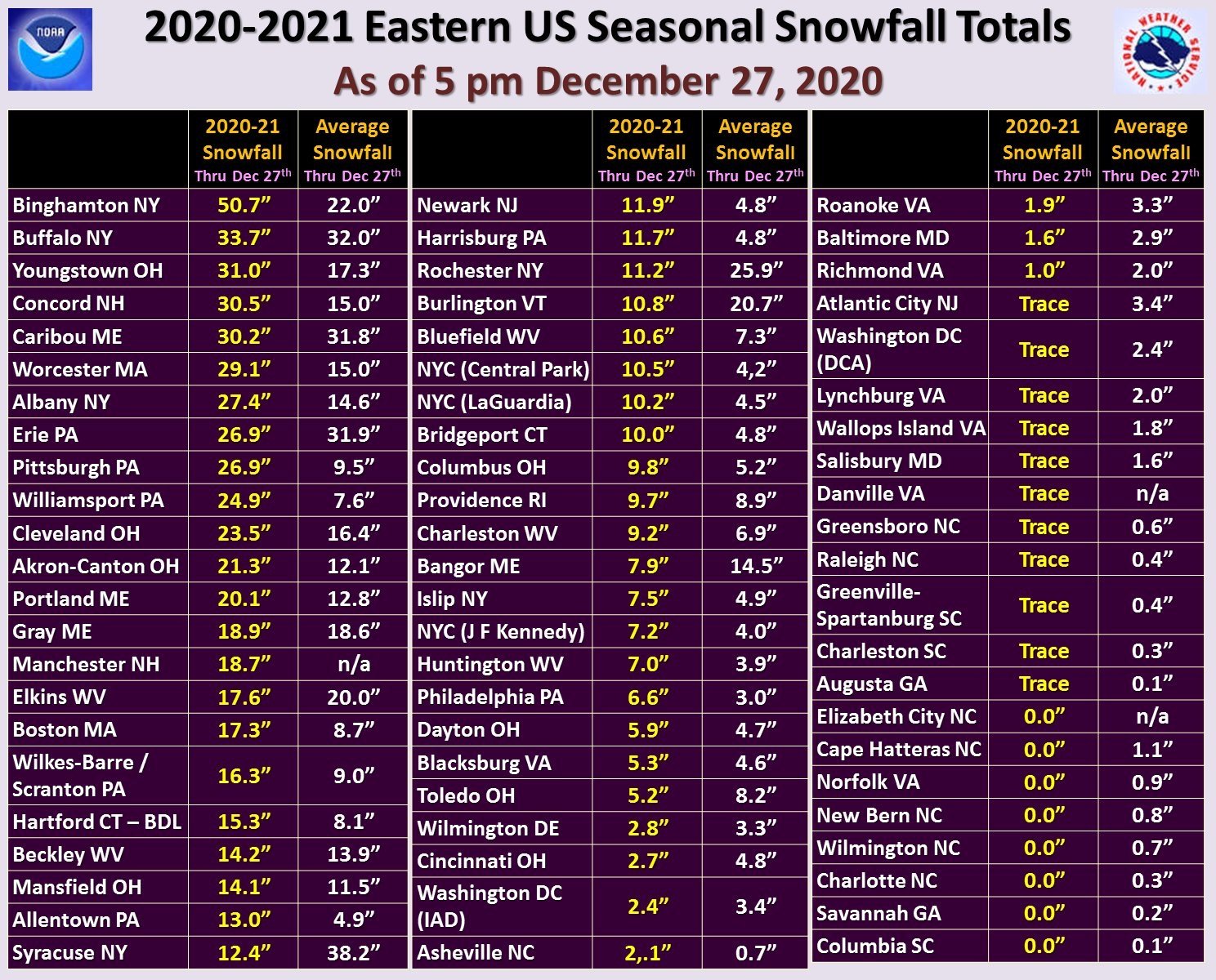
Western Pa / Pittsburgh area Winter Discussion ❄️☃️
north pgh replied to north pgh's topic in Upstate New York/Pennsylvania
I nice squall line about to move in. -
Western Pa / Pittsburgh area Winter Discussion ❄️☃️
north pgh replied to north pgh's topic in Upstate New York/Pennsylvania
We just had a heavy squall cover everything with about 1/2 inch in about 20 minutes. Completely stopped now. Beautiful bands setting up. -
Western Pa / Pittsburgh area Winter Discussion ❄️☃️
north pgh replied to north pgh's topic in Upstate New York/Pennsylvania
Yes in addition to this nice surprise quick thump the models are picking up events in the next couple weeks. Looking good i picked up a solid 2 inches in 1 hour. -
Western Pa / Pittsburgh area Winter Discussion ❄️☃️
north pgh replied to north pgh's topic in Upstate New York/Pennsylvania
Yes it has been a boring couple of weeks with no precip. At least this weekend we should have some snow showers in the air. Next couple weeks hopefully we can start tracking again. -
Western Pa / Pittsburgh area Winter Discussion ❄️☃️
north pgh replied to north pgh's topic in Upstate New York/Pennsylvania
Yes the bitter cold keeps coming down and then retreating but models are now starting to get more stormy. We may have some good storms to track because the cold will pretty much be and place and reinforcing itself after each storm goes by. It looks like Minnesota may have several weeks below zero or close to it second half of January. I have to remember that the last couple of years the models aren't very reliable after 5 days and will go back and forth with storm and no storm. I think we will have things to track starting next week. -
Western Pa / Pittsburgh area Winter Discussion ❄️☃️
north pgh replied to north pgh's topic in Upstate New York/Pennsylvania
If the GFS holds true the week ending January 24th we are going to be getting some extreme cold. Single digit nights to upper teens lower 20s daily. Probably no big storms with that pattern but some potential clippers and lake effect in Northwest flow if it materializes. -
Western Pa / Pittsburgh area Winter Discussion ❄️☃️
north pgh replied to north pgh's topic in Upstate New York/Pennsylvania
It looks like this storm is going to stay south and go out to sea as well. Northwest Flow next weekend might be our first return to any potential snow. -
Western Pa / Pittsburgh area Winter Discussion ❄️☃️
north pgh replied to north pgh's topic in Upstate New York/Pennsylvania
Yes after this week it looks like we get some northwest flow systems with colder air coming into play. I wouldn't mind seeing a few clipper systems come down. Sometimes those 2-4 systems with all cold air work well for us. It's seems like a couple years since we've seen them. -
Western Pa / Pittsburgh area Winter Discussion ❄️☃️
north pgh replied to north pgh's topic in Upstate New York/Pennsylvania
I nice little snow shower popped up and sitting over my area. Picked up a good coating of snow on everything. Very weird and isolated. -
Western Pa / Pittsburgh area Winter Discussion ❄️☃️
north pgh replied to north pgh's topic in Upstate New York/Pennsylvania
Same to you! Don’t be surprised if we get some thunder late day tomorrow -
Western Pa / Pittsburgh area Winter Discussion ❄️☃️
north pgh replied to north pgh's topic in Upstate New York/Pennsylvania
Yes I picked up an inch. I happened to be outside with my sick dog off and on overnight. It started to switch from rain to snow about 2:30 and came down pretty good for about 2 hours. Happy New year everyone and hopefully this year of storms can continue January and February. -
Western Pa / Pittsburgh area Winter Discussion ❄️☃️
north pgh replied to north pgh's topic in Upstate New York/Pennsylvania
-
Western Pa / Pittsburgh area Winter Discussion ❄️☃️
north pgh replied to north pgh's topic in Upstate New York/Pennsylvania
Just remember this from kdka last month,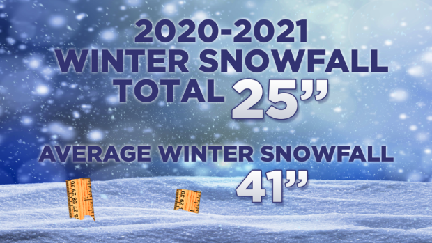
-
Western Pa / Pittsburgh area Winter Discussion ❄️☃️
north pgh replied to north pgh's topic in Upstate New York/Pennsylvania
Picked up another 2 fluffy inches overnight. -
Western Pa / Pittsburgh area Winter Discussion ❄️☃️
north pgh replied to north pgh's topic in Upstate New York/Pennsylvania
Just took out the dog. Off to bed. Moderate snow and blowing snow. I just keep thinking how miserable this group has been with snow events the last couple years. This year I can’t believe it is Christmas Eve. We have had 3 snow events and we are having a beautiful white Christmas. Let’s hope the snows continue into the 2021 season. Merry Christmas everyone! -
Western Pa / Pittsburgh area Winter Discussion ❄️☃️
north pgh replied to north pgh's topic in Upstate New York/Pennsylvania
Sleet here -
Western Pa / Pittsburgh area Winter Discussion ❄️☃️
north pgh replied to north pgh's topic in Upstate New York/Pennsylvania
RadarScope is the best.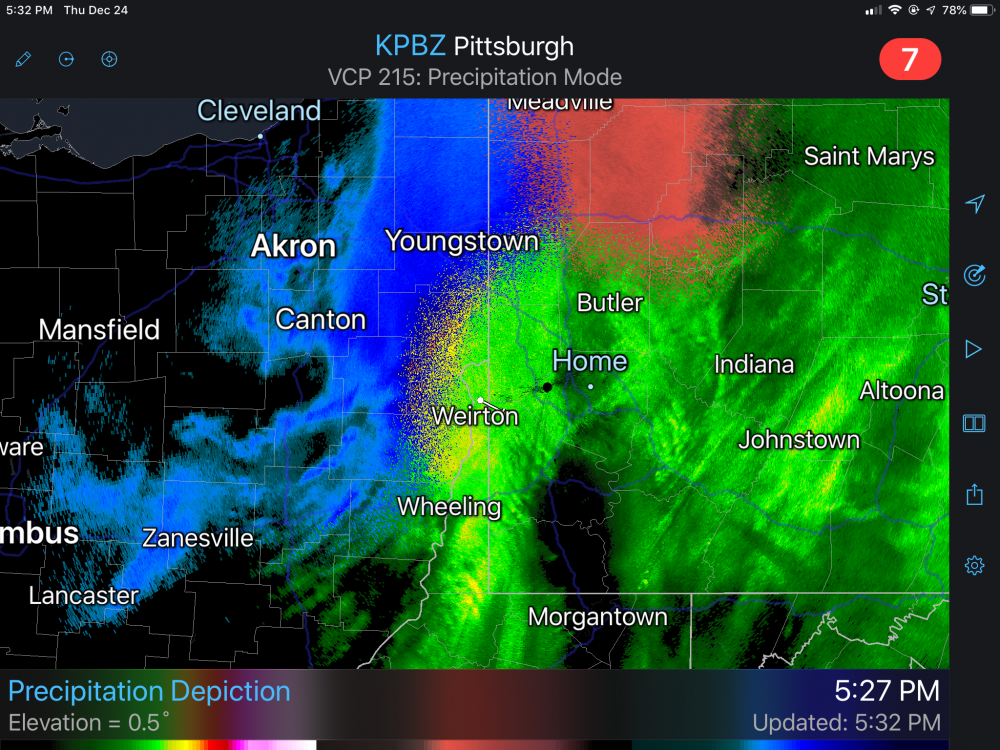
-
Western Pa / Pittsburgh area Winter Discussion ❄️☃️
north pgh replied to north pgh's topic in Upstate New York/Pennsylvania
No it looks like 9:00 pm seems to be changeover time.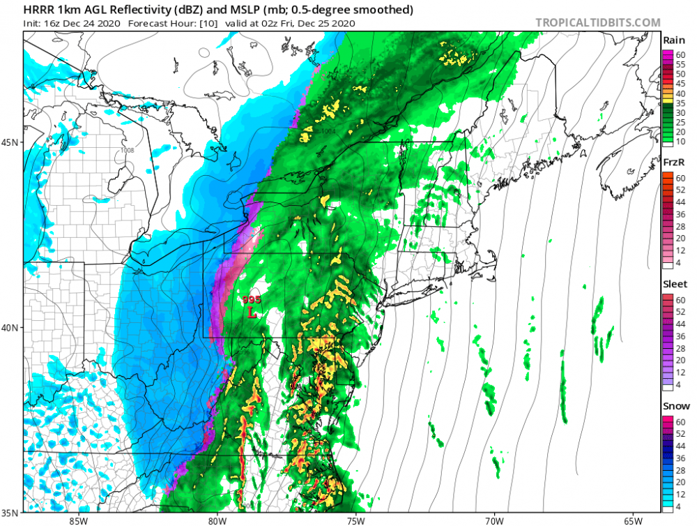
-
Western Pa / Pittsburgh area Winter Discussion ❄️☃️
north pgh replied to north pgh's topic in Upstate New York/Pennsylvania
You too! Higher totals are not a big deal when some of us will have 2-4 and some 4-6. For as many times that we have a brown, warm Christmas I’m happy with a nice coating. This year is a 1 in 20 year thing. -
Western Pa / Pittsburgh area Winter Discussion ❄️☃️
north pgh replied to north pgh's topic in Upstate New York/Pennsylvania
We are the lucky ones this time. 95% of the country would love to be in our spot on Christmas Eve. -
Western Pa / Pittsburgh area Winter Discussion ❄️☃️
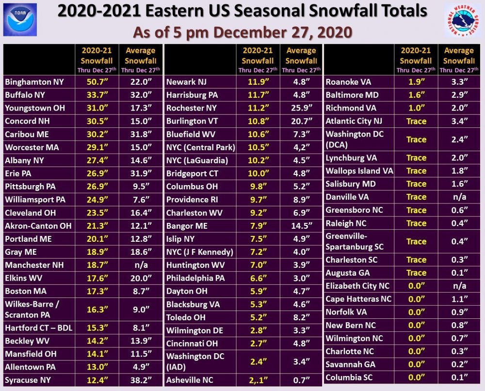
north pgh replied to north pgh's topic in Upstate New York/Pennsylvania
Thru tomorrow afternoon
-
Western Pa / Pittsburgh area Winter Discussion ❄️☃️
north pgh replied to north pgh's topic in Upstate New York/Pennsylvania
Thru midnight
-
Western Pa / Pittsburgh area Winter Discussion ❄️☃️
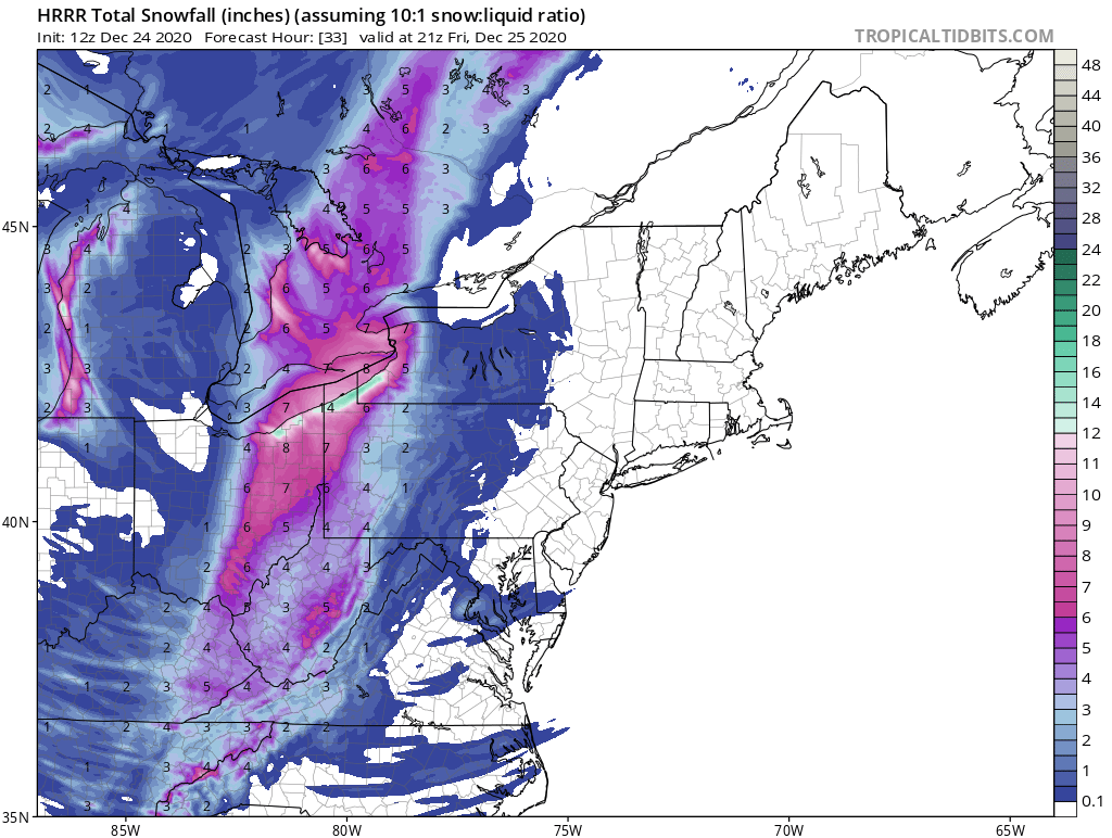
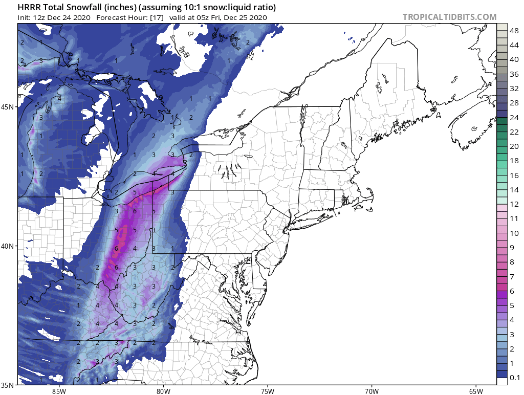
north pgh replied to north pgh's topic in Upstate New York/Pennsylvania
The 18z hrrr 36 hours has us 3-5 in that time period. Maybe not accurate that far out but it gives us a good idea. -
Western Pa / Pittsburgh area Winter Discussion ❄️☃️
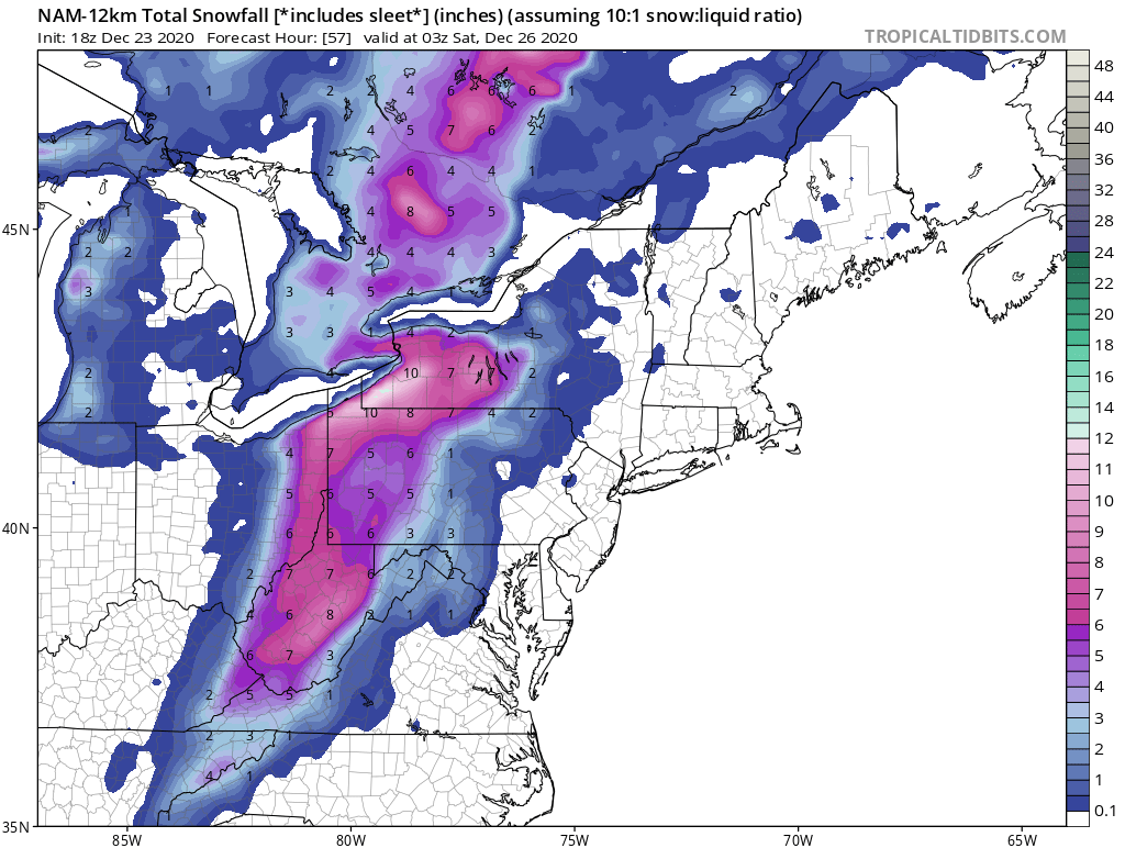
north pgh replied to north pgh's topic in Upstate New York/Pennsylvania
18z NAM
-
Western Pa / Pittsburgh area Winter Discussion ❄️☃️
north pgh replied to north pgh's topic in Upstate New York/Pennsylvania