CoastalWx
-
Posts
176,166 -
Joined
-
Last visited
Content Type
Profiles
Blogs
Forums
American Weather
Media Demo
Store
Gallery
Everything posted by CoastalWx
-
We have a thread for a nice Saturday. Lets talk about it. Anybody have plans????
-
GFS gives weenies hope.
-
Don't worry, GFS gives us a second chance.
-
May not get that.
-
GEFs east too. Good bye and good luck.
-
Kind of a snoozer outside coastline
-
Really slow just off ME coast.
-
east of 00z, close to 6z.
-
GFS will be east I think.
-
I myself and looked at BUFKIT. Even BDL could gust near 50kts. Weak inversion at BOS, but 70kt potential if it breaks.
-
Picks, You can see it goes negative here. I think it would act to help attract it NW because of the venting aloft (divergence).
-
They’re beautiful, but if I go to the beach I want to be in the water lol. Love First Encounter.
-
Love the bay side. No sharks and warm water.
-
Nice! Congrats man.
-
Yep. So in my mind I’m like meh lol. If it’s gonna be windy and rain and nothing special I’ll pass. Better be damaging to ruin a weekend lol.
-
Why not?
-
This probably ticks east
-
I’m also comparing it to October 2021 when it was like 75-80kts on my head
-
Needs to be closer is all I mean. It could be I guess but I’m still not really buying.
-
Offense better be blowing the defense
-
Wake Me Up When September Ends..Obs/Diso
CoastalWx replied to 40/70 Benchmark's topic in New England
Marshfield
-
Wake Me Up When September Ends..Obs/Diso
CoastalWx replied to 40/70 Benchmark's topic in New England
I can count for five times right in that area with has been ridiculous amount of rain. I feel like two or three years ago there was something there too. -
Wake Me Up When September Ends..Obs/Diso
CoastalWx replied to 40/70 Benchmark's topic in New England
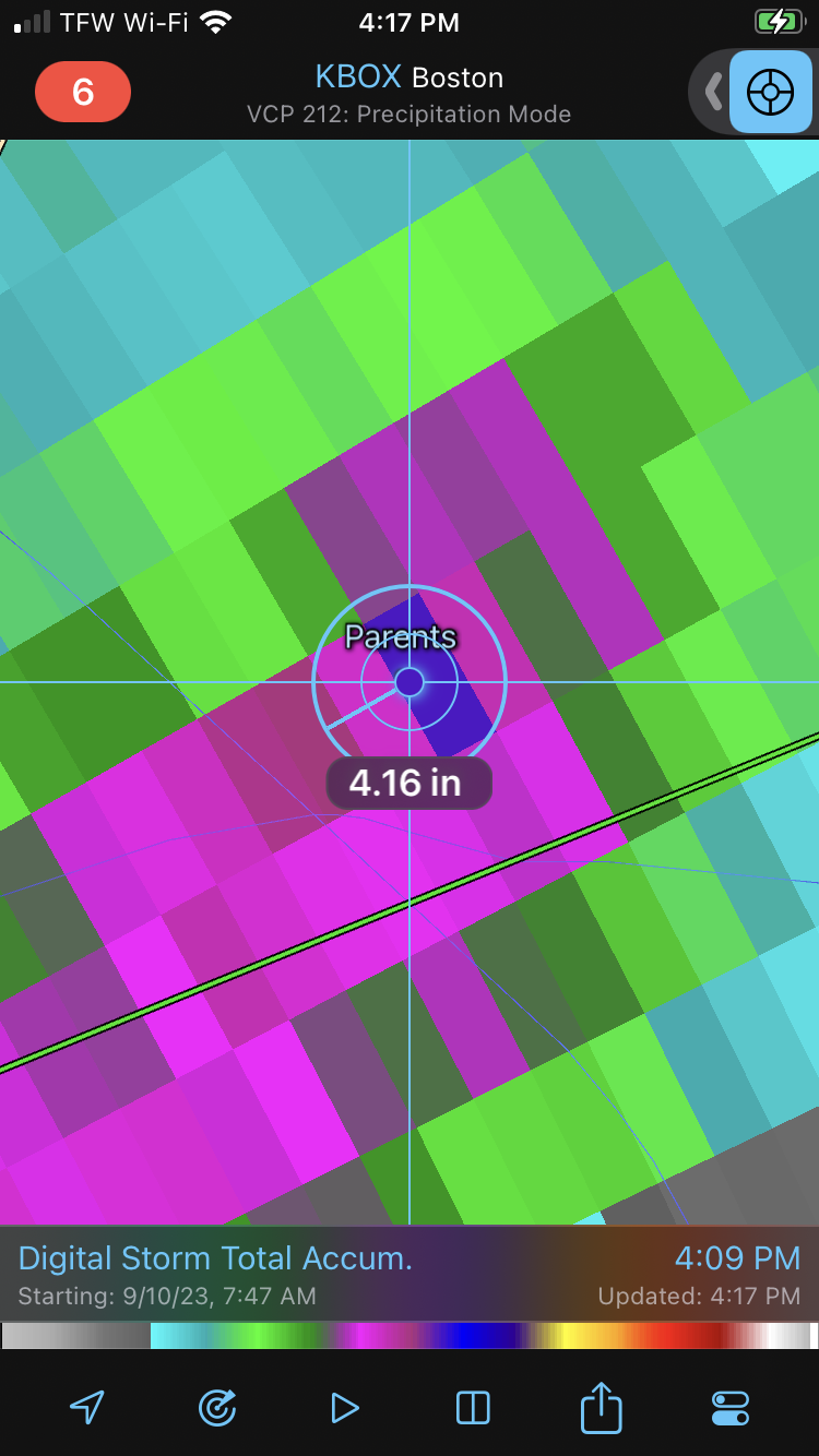
Hydro Phil is all over today -
Wake Me Up When September Ends..Obs/Diso
CoastalWx replied to 40/70 Benchmark's topic in New England
Over 5” estimates by canal