

CoastalWx
-
Posts
176,160 -
Joined
-
Last visited
Content Type
Profiles
Blogs
Forums
American Weather
Media Demo
Store
Gallery
Everything posted by CoastalWx
-
Octorcher or Roctober 2023 Discussion Thread
CoastalWx replied to Damage In Tolland's topic in New England
Still 73 here. Get used to this folks. -
Octorcher or Roctober 2023 Discussion Thread
CoastalWx replied to Damage In Tolland's topic in New England
What a day. 81 for high. -
Octorcher or Roctober 2023 Discussion Thread
CoastalWx replied to Damage In Tolland's topic in New England
King Nothing strikes again. -
Octorcher or Roctober 2023 Discussion Thread
CoastalWx replied to Damage In Tolland's topic in New England
Euro pretty Far East. Oh well. -
Octorcher or Roctober 2023 Discussion Thread
CoastalWx replied to Damage In Tolland's topic in New England
Top 5 summer day. Where was this July and August? -
Octorcher or Roctober 2023 Discussion Thread
CoastalWx replied to Damage In Tolland's topic in New England
Canadian seems east too. -
Octorcher or Roctober 2023 Discussion Thread
CoastalWx replied to Damage In Tolland's topic in New England
We make it rain -
Octorcher or Roctober 2023 Discussion Thread
CoastalWx replied to Damage In Tolland's topic in New England
6z EPS was a little further east. -
Octorcher or Roctober 2023 Discussion Thread
CoastalWx replied to Damage In Tolland's topic in New England
Might actually be able to sneak in a decent chunk of Sunday with fair weather around these parts. -
Octorcher or Roctober 2023 Discussion Thread
CoastalWx replied to Damage In Tolland's topic in New England
I still would like to see 925 a smidge colder I think. Especially towards Kevin’s area. It looks borderline to me. -
Octorcher or Roctober 2023 Discussion Thread
CoastalWx replied to Damage In Tolland's topic in New England
Also looks like far Nrn VT, NH, and ME will see some snow Sunday night into Monday. -
Octorcher or Roctober 2023 Discussion Thread
CoastalWx replied to Damage In Tolland's topic in New England
Yeah it’s gonna grind some, but if that can sharpen even a bit more that would be sweet over the interior. -
Octorcher or Roctober 2023 Discussion Thread
CoastalWx replied to Damage In Tolland's topic in New England
Looks like the odds increased a bit overnight for some interior snow. -
Octorcher or Roctober 2023 Discussion Thread
CoastalWx replied to Damage In Tolland's topic in New England
Because it all depends on codes and what not. I never said I didn’t believe it. But while you’re dropping your pants over hi rise damage, I’m trying to see what happened at the surface. Houses cars etc. we saw that with Michael and Dorian. I haven’t seen it yet. -
Where and how was he found?
-
Any ideas as to leads?
-
Suicide?
-
Octorcher or Roctober 2023 Discussion Thread
CoastalWx replied to Damage In Tolland's topic in New England
It has to do with the onset of precip. So that’s not too crazy. Let not forget two days ago the euro had parakeets for us Sunday and Monday. -
Here is the EPS for 850 wind anomalies. I see some westerly anomalies in the EPAC (probably in part from the tropical activity)..but nothing screams like some sort of crazy feature that will change us to super Nino. The larger WWB is actually retrograding to 135E. If the EPS is right, some WWBs west of the dateline in Novie.
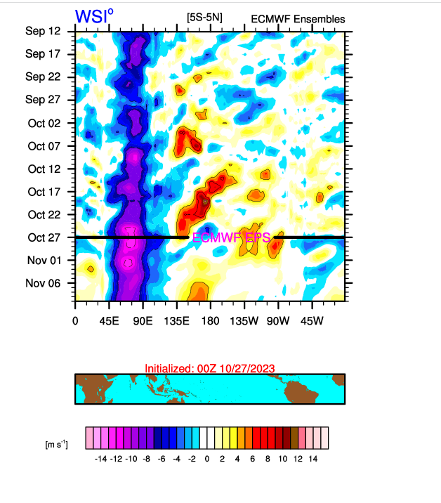
-
Octorcher or Roctober 2023 Discussion Thread
CoastalWx replied to Damage In Tolland's topic in New England
Clown of all clown maps -
I'm not expecting this to act like a cold weak Nino event...but I simply don't see the strong typical response at this time.
-
He's an arrogant tool who falls on his face with calls and doesn't acknowledge them like a respectable poster.
-
I do not see the tropical response or standing wave like we typically have established in other strong Ninos up to this point. This is not behaving like those.
-
Octorcher or Roctober 2023 Discussion Thread
CoastalWx replied to Damage In Tolland's topic in New England
@MaineJayhawk Please make this a meme. -
Octorcher or Roctober 2023 Discussion Thread
CoastalWx replied to Damage In Tolland's topic in New England
Real borderline at 925 south of pike. I think you want a bit more of a dynamic system.


