

CoastalWx
-
Posts
177,027 -
Joined
-
Last visited
Content Type
Profiles
Blogs
Forums
American Weather
Media Demo
Store
Gallery
Everything posted by CoastalWx
-
December 2021 Obs/Disco...Dreaming of a White-Weenie Xmas
CoastalWx replied to 40/70 Benchmark's topic in New England
We’ve melted them over and over since 2010. It’s payback time. -
December 2021 Obs/Disco...Dreaming of a White-Weenie Xmas
CoastalWx replied to 40/70 Benchmark's topic in New England
It’s a torch month. -
December 2021 Obs/Disco...Dreaming of a White-Weenie Xmas
CoastalWx replied to 40/70 Benchmark's topic in New England
When Fairbanks is -35, that’s the composite you get. -
December 2021 Obs/Disco...Dreaming of a White-Weenie Xmas
CoastalWx replied to 40/70 Benchmark's topic in New England
It’s gonna big very mild thanks to most Of the month warm. -
It may look festive with some flakes falling and colder temps. I’m not 100% sold on accumulations but maybe a coating?
-
Yeah change to maybe some light snow and temps falling to maybe 29-30
-
I’d trade your spot. You’ll probably have a nice wintry event under freezing or perhaps only briefly get above it.
-
How about those mesos last night. Lol. The wrf nssl jacked New Bedford lol.
-
December 2021 Obs/Disco...Dreaming of a White-Weenie Xmas
CoastalWx replied to 40/70 Benchmark's topic in New England
Well remember MJO phases won't always fit composites perfectly. It just gives you an idea. -
December 2021 Obs/Disco...Dreaming of a White-Weenie Xmas
CoastalWx replied to 40/70 Benchmark's topic in New England
Yep, now that looks nice. Hope it holds. -
December 2021 Obs/Disco...Dreaming of a White-Weenie Xmas
CoastalWx replied to 40/70 Benchmark's topic in New England
It's not strong, but with that 500 look in the Pacific there will be a propensity for one I think. -
December 2021 Obs/Disco...Dreaming of a White-Weenie Xmas
CoastalWx replied to 40/70 Benchmark's topic in New England
You got your -PNA but trough in Rockies. Davis Strait ridging, and a better 50//50 low. Scooter like. -
December 2021 Obs/Disco...Dreaming of a White-Weenie Xmas
CoastalWx replied to 40/70 Benchmark's topic in New England
A better image albeit stand alone. This look below is much better.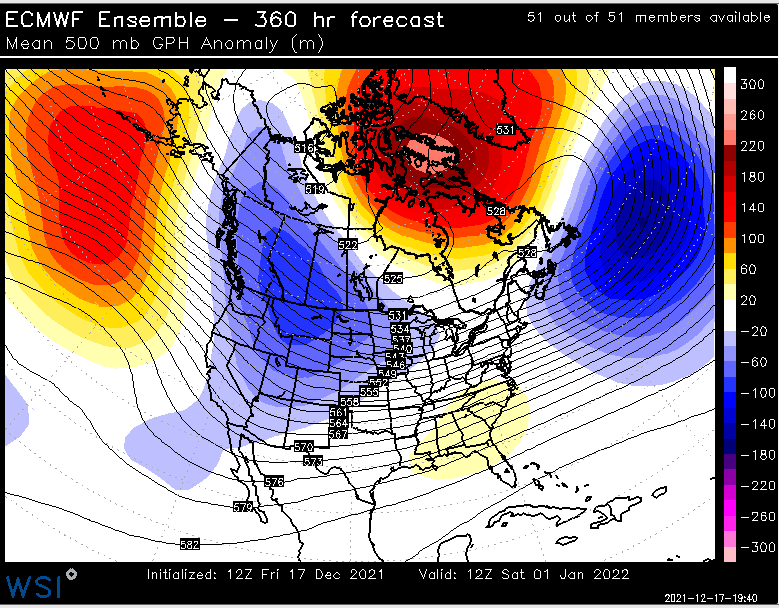
-
December 2021 Obs/Disco...Dreaming of a White-Weenie Xmas
CoastalWx replied to 40/70 Benchmark's topic in New England
Later in the 11-15 day actually shows this. I know you don't want the SE ridge, but to me, that's a more active look with a cold source nearby. Maybe more SWFE or overrunning?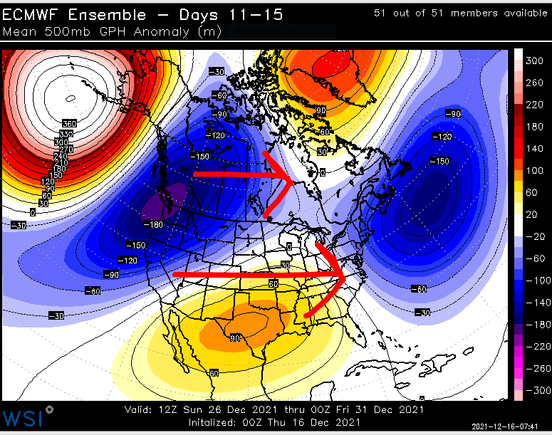
-
December 2021 Obs/Disco...Dreaming of a White-Weenie Xmas
CoastalWx replied to 40/70 Benchmark's topic in New England
A little more help on the EPS and everyone can be Parson Brown on 12/25. -
December 2021 Obs/Disco...Dreaming of a White-Weenie Xmas
CoastalWx replied to 40/70 Benchmark's topic in New England
I just wish I could squeeze those features I drew on yesterday a bit closer together. I think that happens later in month and into January. -
December 2021 Obs/Disco...Dreaming of a White-Weenie Xmas
CoastalWx replied to 40/70 Benchmark's topic in New England
Yeah RE. the one that did not work, that low to the east would just force everything down to our south. Sort of like what the GFS op did. -
December 2021 Obs/Disco...Dreaming of a White-Weenie Xmas
CoastalWx replied to 40/70 Benchmark's topic in New England
Well the confluence to our NE could cause it. In any case, I'd take the look overall. -
December 2021 Obs/Disco...Dreaming of a White-Weenie Xmas
CoastalWx replied to 40/70 Benchmark's topic in New England
Canadian -
December 2021 Obs/Disco...Dreaming of a White-Weenie Xmas
CoastalWx replied to 40/70 Benchmark's topic in New England
Ha, I didn't even see that when I looped it. That would work. -
December 2021 Obs/Disco...Dreaming of a White-Weenie Xmas
CoastalWx replied to 40/70 Benchmark's topic in New England
GEFS show some potential after Christmas. That's when things were sort of getting more on track anyways. The stuff before Christmas was a lower chance as many have said. -
December 2021 Obs/Disco...Dreaming of a White-Weenie Xmas
CoastalWx replied to 40/70 Benchmark's topic in New England
Yeah I'm ok with that. -
December 2021 Obs/Disco...Dreaming of a White-Weenie Xmas
CoastalWx replied to 40/70 Benchmark's topic in New England
Kevin, is that you? -
December 2021 Obs/Disco...Dreaming of a White-Weenie Xmas
CoastalWx replied to 40/70 Benchmark's topic in New England
I actually like that look though. -
December 2021 Obs/Disco...Dreaming of a White-Weenie Xmas
CoastalWx replied to 40/70 Benchmark's topic in New England
The 80s had a few mid atlantic specials.


