

RitualOfTheTrout
-
Posts
3,693 -
Joined
-
Last visited
Content Type
Profiles
Blogs
Forums
American Weather
Media Demo
Store
Gallery
Everything posted by RitualOfTheTrout
-
 Yeah, Nobody should be discounting any outcome, case in point just quickly looking at 18z GEFS there are more members getting the whole state in on the action.
 -
Stronger storm \ negative tilt trough sooner and or slightly less confluence to the north and I think it could easily shift enough to get us more involved. Of course things could trend the other way and we are partly cloudy cold and dry. Either way, we all know what was modeled today is very unlikely to be the exact end result hence why people always say they don't want to be in the bullseye 5-6 days out.
-
I’ll echo that sentiment. Looks like the upcoming blocking regime may help mute the Nina effects. It really just started showing up, a few days ago it looked like lights out for awhile. In my experience that’s usually how it goes when the blocking actually happens; models catch on in the medium range rather than chasing day 14 “trends”. If we can get the pacific just little more favorable (more ridge out west) that would aid our chances. Either way it looks active next week, I’d be surprised if there isn’t at least one good snow storm somewhere in the East. Time will tell how many rolls of the dice we get. If blocking is a recurring theme that should help make this a decent year despite the Nina. Now watch the incoming geomagnetic storm fudge up the stratosphere and wreck the blocking.
-
Western Allegheny is getting smoked by looks on radar. Looks like some 35dbz returns on radar. I've been teetering on the Eastern edge of the better rates but heck of an event to start December for sure. Some areas may hit December whole month climotolgy snow totals on day one.
-
Coming down pretty good now. With sunset approaching pavement starting to get covered in a few places.
-
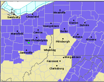
.NEAR TERM /THROUGH TONIGHT/... Snow will generally continue overnight as moisture wraps around an upper low tracking into southeastern Canada. An embedded shortwave will give one last southward push of snow this evening, potentially aiding in heavy snow band development along the I-80 corridor. During this last push, strong upper jet dynamics, steepening low level lapse rates and enough dendritic growth will promote an additional 1-2" of snow across eastern OH and southwestern PA while northwestern PA and the eastern ridge tops could see another 3-6" of snow. Thus, the Winter Storm Warnings and Winter Weather Advisories will continue. I think if the above comes to fruition definitely not out of the question some areas in SWPA push 6 especially areas already closing in on 4in.
-
I've been watching that area on radar, it's been just to the NW of mby now for awhile, hopefully it can push SE just a bit more as there are some steady 20-25 dbz returns showing up.
-
Hard to get a good measurement with some melting with the warm ground but I'd say somewhere between 1.5in 2in at 11am. I woke up around 4am and we had flipped to snow, but there was nothing accumulated at the time.
-
I think the main difference here is the storm stalls out for a bit once we get on the cold side. That combined with some lake enhancement should prolong the window vs a storm taking the same track that just zips off to the NE. Not saying to expect high end of any of the totals but I have more confidence than usual given the setup.
-
Can’t complain about a 1-3 to start Meteorological Winter. This will be interesting to see how fast temperatures can crash. Afterwards, pattern looks active. Given it’s still early and LaNina favored climo, cold air might be problematic but at least for now doesn’t appear we will be in a shutout pattern to start the season.
-
Pittsburgh PA Spring and Summer 2020 Thread
RitualOfTheTrout replied to meatwad's topic in Upstate New York/Pennsylvania
Looks like the first accumulation of the season is possible tomorrow evening / night, probably only looking at a coating at best outside of the favored I80 / upslope regions but time to knock off the tracking rust. -
Pittsburgh PA Spring and Summer 2020 Thread
RitualOfTheTrout replied to meatwad's topic in Upstate New York/Pennsylvania
Well that escalated quickly, I think we made a dent in that drought map today. Power knocked out too. -
Pittsburgh PA Spring and Summer 2020 Thread
RitualOfTheTrout replied to meatwad's topic in Upstate New York/Pennsylvania
Finally got a good soaking rain today. It’s been interesting seeing the storms find different ways to dissipate before getting to me this week. Today appears to be no different but at least managed some rain. Lawn was starting to look like mid August than early to mid July with how brown it is. Case in point, watch the line just dissolve. Must be something to do with terrain as this happen pretty frequently year round, although today is partially plagued by some rain earlier that probably stabilized the atmosphere.
-
Pittsburgh PA Spring and Summer 2020 Thread
RitualOfTheTrout replied to meatwad's topic in Upstate New York/Pennsylvania
That's one of the best snow maps I've seen all "Winter" lol. I mean if its going to be cold and precipitation falling I'm all in for something record setting which has Burghblizz mentioned in May wouldn't take much. Heck if I see a coating of snow on May 9th I'd consider that a win. I know anecdotally we welcome the cold snaps in Spring to kill bugs etc, just curious what impact an actual hard freeze this late would do to mosquitoes etc. -
Pittsburgh PA Spring and Summer 2020 Thread
RitualOfTheTrout replied to meatwad's topic in Upstate New York/Pennsylvania
Looks like snow for Mother’s Day weekend is possible... .LONG TERM /THURSDAY THROUGH SUNDAY/... Dry and cool conditions resume Thursday before another shortwave returns rain chances Friday and Saturday. Models are in above average agreement with heights and temperatures aloft heading into the weekend...with values 2-3 standard deviations below normal and 30 year return intervals. By Saturday morning 540 thickness is as far south as the carolinas and h850 temps over the forecast area will be between -7 and -8C. Although sfc temperatures will be above freezing during the day precipitation should be all snow based off temps aloft. Breaks in the clouds and May insolation should result in at least a marginal amount of sfc based CAPE given the cold air aloft (convective temps will be in the low 40s)...and that with a saturated DGZ there could be brief periods snow intensity high enough to get some measurable amounts (higher than a trace) during the day before melting. The last time in PGH where May snow was anything more than a trace was 1966, and measured snow greater than a trace has only occurred six time in the period of record. Early morning temperatures in the extended will be abnormally cold; frost/freeze headlines may be needed if current model trends continue. -
Pittsburgh PA Spring and Summer 2020 Thread
RitualOfTheTrout replied to meatwad's topic in Upstate New York/Pennsylvania
That’s what I was just saying to my wife, fall / winter / spring have basically merged into one 6 month period of blah. I just saw this article in the Trib, nothing surprising and pretty much predicts what we have been saying. PA Climate Story We will of course still get snow, but it will take an increasingly anomalous pattern as we proceed into the future. It is crazy to see some of the short term effects of the drops in pollution due to COVID-19 stay at home stuff. It’s too bad we don’t have a way to feasibly cut it like this indefinitely. An abstract macabre thought... maybe COVID-19 is actually the planets immune system trying to eliminate a virus.. us! Yeah the quarantine is probably starting to affect my mental state. -
Pittsburgh PA Spring and Summer 2020 Thread
RitualOfTheTrout replied to meatwad's topic in Upstate New York/Pennsylvania
That's the problem, it too bad we couldn't get a pattern like this in the December - March time frame... -
Pittsburgh PA Spring and Summer 2020 Thread
RitualOfTheTrout replied to meatwad's topic in Upstate New York/Pennsylvania
Pretty intense snow squall moving through here right now. Some pretty strong gusts and brief whiteout. Even managed to briefly whiten the roads. What a week of weather, 70s, tornado, snow squalls, par for the course for western PA spring I guess lol -
Pittsburgh PA Spring and Summer 2020 Thread
RitualOfTheTrout replied to meatwad's topic in Upstate New York/Pennsylvania
Yeah it was crazy for sure. I saw the line of storms on radar, but when it hit it meant business. Within a few seconds it seemed to go from relative calm to hail banging of the windows and the power started flickering and then was out then about 45 seconds later both of our phones went off with the Wireless Emergency Alert for a Tornado Warning. I ran and looked out the kitchen window to a sight I have never witnessed since living here. Already the roar was was incredible from the wind and I said get the kids and get downstairs now, this is for real. There was probably a 45 second period where the sound was so deep, as they say almost like a freight train. We could hear the deck furniture start sliding and them slamming off the rail and then almost as quickly as the whole thing started the wind died down (relatively speaking) and it was done. I'm thinking that period was probably the tornado at its closest proximity but can't be sure. We were lucky, very little damage. Ripped off a downspout and the chimney cap, lots of branches etc but the biggest thing the kids trampoline was blown into the trees and got mangled up pretty bad. The other bad thing is we were without power for about 12-13 hours so most of the food in the refrigerator was lost. I think I'm good on severe weather now, I'd be good with saving all the "interesting" weather for the upcoming winter season. -
Pittsburgh PA Spring and Summer 2020 Thread
RitualOfTheTrout replied to meatwad's topic in Upstate New York/Pennsylvania
Power out here, tornado warning, roughest 10 minutes of weather I’ve witnessed in a long time. We ran to the basement with the kids when the tornado alerts went off. -
Pittsburgh PA Spring and Summer 2020 Thread
RitualOfTheTrout replied to meatwad's topic in Upstate New York/Pennsylvania
Things look to get interesting in the next hour or so. With all of the quarantine / stay at home stuff the kids bedtime has been slipping later and later. I expect that line coming through will wake them. -
Picture is worth a thousands words... Insanity Winter 2018-2019 Is Doing the Same Thing Over and Over Again and Expecting Different Results.
-
Just miserable cold rain.. Maybe we should start tracking mud slides.
-
Easy there... Let's not get carried away lol. I need a new lawn mower this spring so I'm even less enthusiastic about grass cutting season starting. Anyone have any good recommendations on a good push mower? Prefer non-self propelled. I had a basic Craftsman with a 5.50hp Briggs and Stratton engine but it would tend to bog down at time. It was a good mower though otherwise, started on first pull even after long time in the garage. Had it 11 years but it started smelling like gas while sitting in the garage this past year but no evidence of a leak and revving up and down while running. Then this fall on the last cut it started backfiring then wouldn't start. Not sure how interested I am in trying to fix it.
-
That and most stores will be empty from a people perspective. I think everyone blitzed the grocery stores last night and early morning.


