

RitualOfTheTrout
-
Posts
3,687 -
Joined
-
Last visited
About RitualOfTheTrout

Recent Profile Visitors


-
Gotta love March. Lol
-

Pittsburgh/Western PA WINTER ‘25/‘26
RitualOfTheTrout replied to Burghblizz's topic in Upstate New York/Pennsylvania
Hazardous Weather Outlook National Weather Service Pittsburgh PA 439 AM EDT Tue Mar 17 2026 OHZ039>041-048>050-057>059-068-069-PAZ013-014-020>022-029-031-073- 075-WVZ001>004-012-021-509-180845- Tuscarawas-Carroll-Columbiana-Coshocton-Harrison-Jefferson OH- Muskingum-Guernsey-Belmont-Noble-Monroe-Lawrence-Butler-Beaver- Allegheny-Armstrong-Washington-Greene-Westmoreland-Fayette-Hancock- Brooke-Ohio-Marshall-Wetzel-Marion-Monongalia- 439 AM EDT Tue Mar 17 2026 This Hazardous Weather Outlook is for east central Ohio, southwest Pennsylvania, western Pennsylvania, and northern West Virginia. .DAY ONE...Today and tonight. The chance for snow showers is forecast to ramp up this afternoon mainly for western Pennsylvania and northern West Virginia counties. There is a high probability for getting at least another inch of snow in parts of these areas. Eastern Ohio could see measurable snow from the afternoon showers, however, it is likely to remain under an inch. .DAYS TWO THROUGH SEVEN...Wednesday through Monday. No hazardous weather is expected at this time. .SPOTTER INFORMATION STATEMENT... Spotter activation is not expected at this time. $$ Lupo Special Weather Statement Special Weather Statement National Weather Service Pittsburgh PA 849 AM EDT Tue Mar 17 2026 OHZ040-041-050-PAZ013-014-020>022-029-073-075-WVZ001-002-171600- Carroll-Columbiana-Jefferson OH-Lawrence-Butler-Beaver-Allegheny- Armstrong-Washington-Westmoreland-Fayette-Hancock-Brooke- Including the cities of Carrollton, Malvern, East Liverpool, Salem, Columbiana, Steubenville, New Castle, Ellwood City, Butler, Aliquippa, Beaver Falls, Ambridge, Monaca, Pittsburgh Metro Area, Kittanning, Ford City, Washington, Canonsburg, Murrysville, Greensburg, New Kensington, Lower Burrell, Latrobe, Monessen, Uniontown, Weirton, Follansbee, and Wellsburg 849 AM EDT Tue Mar 17 2026 ...SNOW SHOWERS REDUCING VISIBILITY... Scattered snow showers and localized heavy bands of snow will continue this morning. Visibility could briefly be reduced to a quarter of a mile or less in the heaviest snow, with a quick inch or two of accumulation. Additional snow showers and localized heavy bands will be possible through this afternoon. Use caution if traveling. $$ -
Pittsburgh/Western PA WINTER ‘25/‘26
RitualOfTheTrout replied to Burghblizz's topic in Upstate New York/Pennsylvania
Its dumping heavy snow here again. Gotta love these March snow events. Might make it over 7 inches. -
Pittsburgh/Western PA WINTER ‘25/‘26
RitualOfTheTrout replied to Burghblizz's topic in Upstate New York/Pennsylvania
Borderline snow squall rolling through, wind ripping and moderate to heavy snow. -
Pittsburgh/Western PA WINTER ‘25/‘26
RitualOfTheTrout replied to Burghblizz's topic in Upstate New York/Pennsylvania
Dang, 5.2, can they hit 6 if a couple of those snow showers hit over night? -
Pittsburgh/Western PA WINTER ‘25/‘26
RitualOfTheTrout replied to Burghblizz's topic in Upstate New York/Pennsylvania
I wasn't expecting more than 2 to be honest. I definitely underestimated the rates ability to overcome the warm ground. Glad it hit late day. We still got to have some daylight snow but the sun wasn't a factor. -
Pittsburgh/Western PA WINTER ‘25/‘26
RitualOfTheTrout replied to Burghblizz's topic in Upstate New York/Pennsylvania
Same. Just measured 4 on the deck. Its highly variable based on the surface. -
Pittsburgh/Western PA WINTER ‘25/‘26
RitualOfTheTrout replied to Burghblizz's topic in Upstate New York/Pennsylvania
Somewhere probably passes 3in on this. Already surpassed my expectations. -
Pittsburgh/Western PA WINTER ‘25/‘26
RitualOfTheTrout replied to Burghblizz's topic in Upstate New York/Pennsylvania
It helps it was overcast all day, but also rates and late evening can overcome warm ground. -
Pittsburgh/Western PA WINTER ‘25/‘26
RitualOfTheTrout replied to Burghblizz's topic in Upstate New York/Pennsylvania
Ripping heavies here! Wind is gusting too! Pavement and sidewalks caved. -
Pittsburgh/Western PA WINTER ‘25/‘26
RitualOfTheTrout replied to Burghblizz's topic in Upstate New York/Pennsylvania
I'm not expecting much accumulation, but I won't be mad if I see some moderate to heavy snow briefly. NWS did mention amounts increased again with 12z, it should help it will be late evening so sun angle won't be a huge impact, it will just need to overcome the warmer ground. -
Cover your ears, don't get pulled into that siren song that is 70s in March. Get yourself together, your melting like the Bruins with a 3-0 lead!
-
Pittsburgh/Western PA WINTER ‘25/‘26
RitualOfTheTrout replied to Burghblizz's topic in Upstate New York/Pennsylvania
Don't get me wrong, the warm temperatures are great, but we have like 8 months of almost 0 chance for meaningful snow, so if a realistic threat window for 6 plus is legit Im all in. 18z GFS was a clown run for January standards let alone mid March.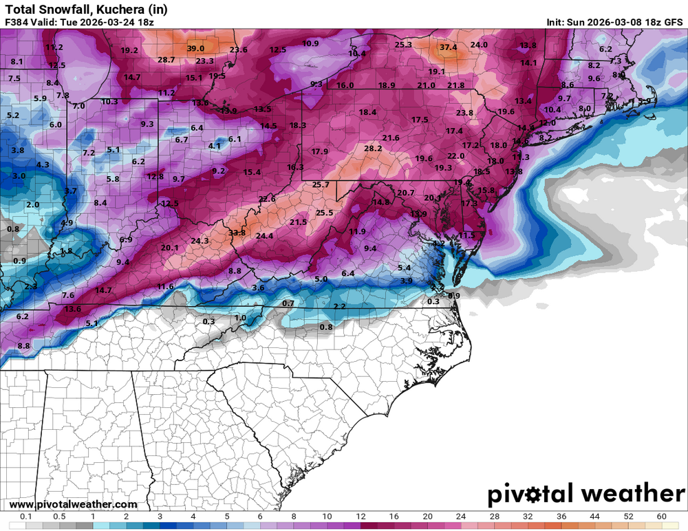
-
Pittsburgh/Western PA WINTER ‘25/‘26
RitualOfTheTrout replied to Burghblizz's topic in Upstate New York/Pennsylvania
That's an acceptable March snow right there. -
Pittsburgh/Western PA WINTER ‘25/‘26
RitualOfTheTrout replied to Burghblizz's topic in Upstate New York/Pennsylvania
Time it with a big snow storm and Ill take it, otherwise yeah, save it til December. It also looks to be pretty short lived, warmth probably starts rebuilding a few days after. If it falls through I don't think many will be upset.


