

Voyager
-
Posts
13,309 -
Joined
Content Type
Profiles
Blogs
Forums
American Weather
Media Demo
Store
Gallery
Posts posted by Voyager
-
-
42 minutes ago, mahantango#1 said:
62 was the high today.
Look at you. Not only do you beat my lows, but now you're beating my highs, too.
Knock it off already...

-
Got up to 60.1 in Tamaqua today.
-
1 hour ago, Mount Joy Snowman said:
We have loads of sun down here.
It was off and on here for awhile. Now, finally, we are wall to wall blue skies.
-
 1
1
-
-
5 minutes ago, Albedoman said:
Friends, the drought guy here has shown my experience now. I finally had enought time the last few weeks to gather my educational background information to provide the board with earning my met tag. Thanks guys
Congrats!
-
15 hours ago, RedSky said:
Guidance support today for a PV split and invasion second half of March
Man, I've had enough. And why is it that every time the PV splits, it heads right for the northeast? Why can't it go west once in awhile?
-
1
-
-
53 minutes ago, Mount Joy Snowman said:
Low of 31. Splendid day on tap today. I’m going to take the kids to the park. I imagine everyone will be out and about. Then a few days of crappy weather before we get the prolonged warmup. But winter is still lurking for late March.
I thought today was supposed to be as sunny as yesterday. Right now we're close to a solid overcast again.
-
On 2/25/2026 at 1:21 PM, RedSky said:
Today's euro mega torches after next Wednesday, a week of false spring?
I don't want to hear about false spring. I want real spring.
Also, gotta ask, why is it that when the PV splits, it always beelines it for east and not the West?
-
1
-
-
Cracked 50 today!!!
Currently 51 in the backyard.
-
 1
1
-
-
2 minutes ago, Jsauss said:
jesus, you're old

Hell, I was 14 years old for that April 82 storm. Remember it quite well. I think we got somewhere between 8 and 12 inches out of that one in Bethlehem. If I remember right, I think we had a single digit low the morning after as well.
Crazy chain of events with that one.
-
35 minutes ago, canderson said:
Time change next weekend so it seems tracking season so just about kaput for me. It was a nice winter.
I hate bugs but next eeek they’ll start coming back.
Yup. I'm going to go from salty windshields to buggy windshields. I don't mind the bugs, but with me doing trucking videos, the biggest, messiest bug splat seems to always happen right in my camera view...lol
-
31 minutes ago, mahantango#1 said:
18 this morning.
19.6 here. Funny how 20 with no wind doesn't feel all that cold.
-
1
-
-
48 minutes ago, MAG5035 said:
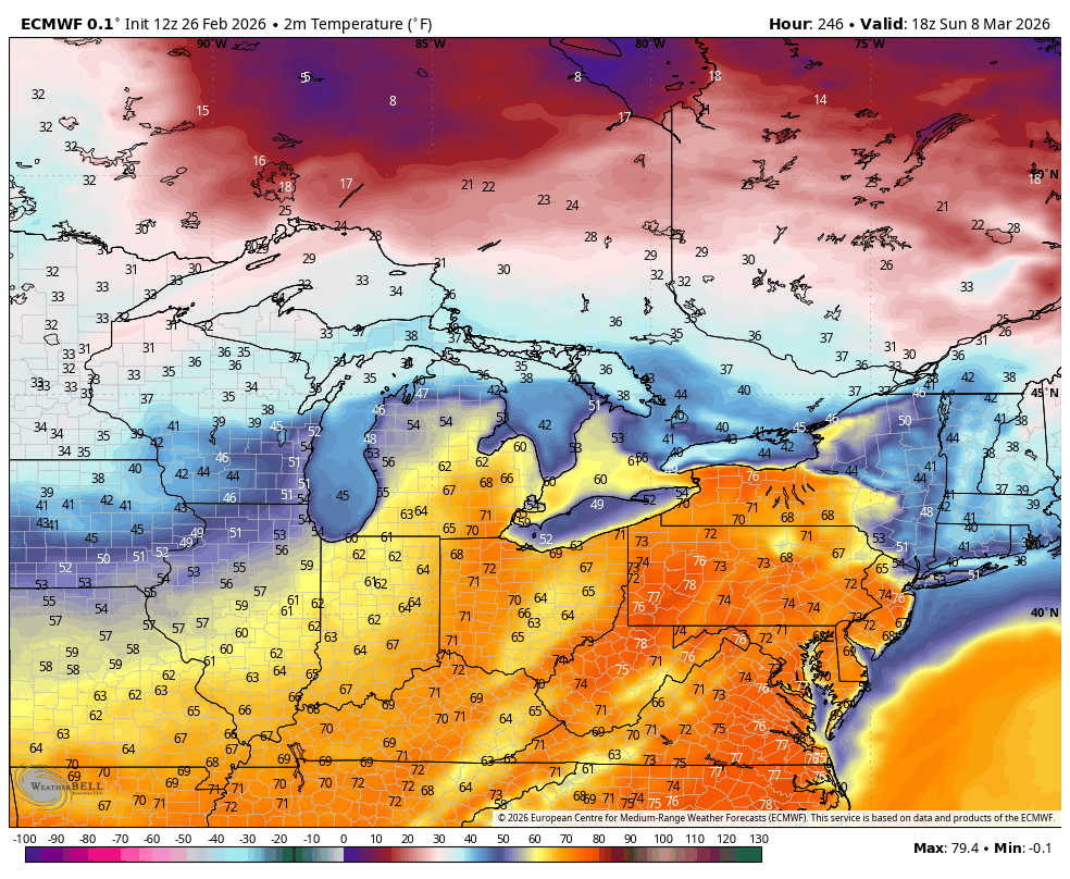
This one’s for you @Voyagerhaha. Once we route out the lingering cold later next week after whatever happens Monday, guidance shifts high pressure to a Bermuda high positioning and that would likely usher in the warmest air we’ve seen since about October. Euro/GFS both have multiple days in the 70s late next week into next weekend. Given setup and teleconnections (+AO/NAO, +EPO, -PNA) I don’t think this one get’s muted.
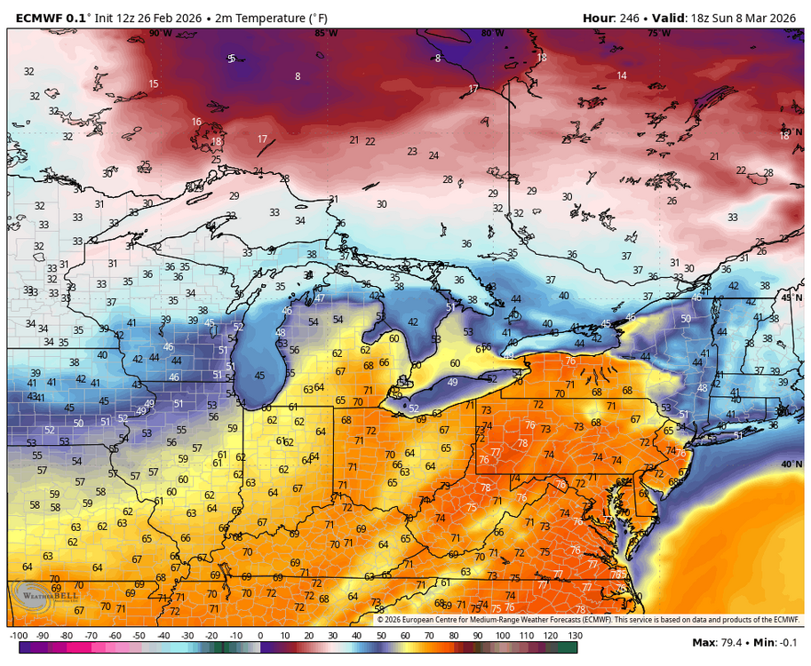
Thanks for posting this. I know I'm in the minority, and sometimes I can be overbearing, but I really needed a spirit pick me up. I've been about as depressed as I've ever been this winter.
-
43 in the Tamaqua backyard at 10:30am. Even warmer here in Allentown. Hopefully we get a full sunny day today. That way, all of the old snowpack will be gone before anything next week materializes.
-
17 minutes ago, Ralph Wiggum said:
I am fine with this and then touching 70 by the following week. Would be a fitting finale to a really good winter!
13 minutes ago, Duca892 said:I would love just one last warning level snow and then gladly move right on to spring
I'm so torn on this. Part of says yes, give the winter snow guys one last storm, but part of me is quite happy seeing more and more bare ground each day.
I'm not sure I want to start the melting process all over again.
-
1
-
-
11 minutes ago, mahantango#1 said:
Yes, one last hurrah!
I don't have any hurrahs left in me...

-
 1
1
-
-
4 hours ago, Jns2183 said:
March 15 is the cliff
Sent from my SM-S731U using Tapatalk
I just saw a couple posts on Facebook that nearly pushed me over the edge. Both of them talked about another PV split, and that after a bit of a warmup, winter returns and may last into early April.
They actually made me hide all weather posts on Facebook from pro and amateur mets. I can't take the depression any more.
I just can't...
-
34 minutes ago, Mount Joy Snowman said:
The monthly, seasonal, and annual climate summary reports for the official stations roughly sum things up. See below for an example from January's report.
SKY COVER
POSSIBLE SUNSHINE (PERCENT)   MM
AVERAGE SKY COVER           0.62
NUMBER OF DAYS FAIR            4
NUMBER OF DAYS PC             16
NUMBER OF DAYS CLOUDY         11

AVERAGE RH (PERCENT)     63

WEATHER CONDITIONS. NUMBER OF DAYS WITH
THUNDERSTORM              0     MIXED PRECIP               0
HEAVY RAIN                0     RAIN                       1
LIGHT RAIN                5     FREEZING RAIN              0
LT FREEZING RAIN          1     HAIL                       0
HEAVY SNOW                2     SNOW                       4
LIGHT SNOW                7     SLEET                      2
FOG                      13     FOG W/VIS <= 1/4 MILE      4
HAZE                      3
Thanks! I'll have to look it up for December and February.
-
56 minutes ago, pawatch said:
What sun angle? It’s been cloudy almost everyday

Actually, I was going to ask about that. Does anyone have stats on cloudy vs sunny days? Besides the cold and wind, it seems like it's been exceptionally cloudy this winter.
-
I see 1-2 for Tuesday night, another 1-2 maybe on Thursday, and then another possible storm next Monday.
Make it stop already...

-
1 minute ago, JTA66 said:
You be right up the street from me. We'll meet at Whelihan's when you're finished and pound some beer before your return trip
")
Seriously, I haven't been out yet but guestimate maybe 9-10" from the window. My side street has be plowed and it's just blacktop this morning. Safe travels!!
Thanks much!
I could use an adult beverage or three as I'm quite wound up this morning.
-
And now it stopped...
-
I'm hoping it keeps going in the Lansdale area, and the Penndot restrictions hold well into the afternoon. I really don't want to go down there today.
-
1
-
-
6 minutes ago, The Iceman said:
18” @ 5 am
Nice!
-
Ok, not sure what's going on. Got a moderate snow with big fatties falling, yet there's nothing overhead on radar. Must be low topped clouds under the radar beam.
Anyway. I just measured 3" on the hood of my white GMC Terrain that didn't go anywhere since 8am yesterday. So I suppose it's sort of a white board...lol.
-
1
-
Central PA Winter 25/26 Discussion and Obs
in Upstate New York/Pennsylvania
Posted
Sounds good to me. After yesterday, most to all of the snowpack is gone, and I really don't want to see it return.