

Voyager
-
Posts
13,309 -
Joined
Content Type
Profiles
Blogs
Forums
American Weather
Media Demo
Store
Gallery
Posts posted by Voyager
-
-
2 hours ago, Albedoman said:
While many people are enjoying the recent stretch of cooler temperatures and low humidity, this weather pattern is becoming increasingly concerning for farmers and water resources throughout the Lehigh Valley.
Lehigh County is now officially under a Pennsylvania DEP Drought Warning, reflecting the continued deterioration of soil moisture, groundwater supplies, and streamflows. Residents are being asked to voluntarily conserve water as the drought continues to worsen.
The comfortable weather is actually working against agriculture. Lower humidity, cool nights, breezy afternoons, and the lack of widespread soaking rains continue to dry out already stressed soils. Corn, soybeans, hay, vegetables, orchards, and pasturelands are all feeling the effects, and each rain-free day adds more stress to this year's crops. Lehigh County already has thousands of acres of corn, soybeans, and hay currently experiencing drought conditions.
Another concern has been the apparent pattern over the past three weeks where numerous showers and thunderstorms have weakened, split apart, or tracked around portions of the Lehigh Valley, leaving many locations with little or no meaningful rainfall while surrounding areas received much heavier amounts. Whether you call it the local "donut hole" or simply an unfortunate weather pattern, the result has been the same—many farms have missed the widespread soaking rains desperately needed to recharge soil moisture.
Perhaps most concerning, there are currently no tropical systems or significant tropical moisture plumes on the immediate horizon that appear capable of delivering the widespread one- to three-inch rainfall that would substantially improve drought conditions.
Many people are enjoying this beautiful summer weather today, but if this dry pattern continues into August, opinions will likely change quickly. Brown lawns, stressed crops, falling stream levels, declining groundwater supplies, and increasing wildfire concerns could become the story of the summer.
The Lehigh Valley doesn't need another picture-perfect day—it needs several widespread soaking rains.
Driving back and forth over the Blue Mountain multiple times per day, it's easy to see the haves and have nots just by looking at the lawns on either side. Green in Schuylkill County and brown in Lehigh County.
-
3 minutes ago, pawatch said:
48 degrees this morning. Maybe start the day in jeans

53 this morning here. I'd be wearing jeans today for work if I had an earlier start than 8am. By the time I load the first tank of the day, the sun is starting to warm things up.
Gonna need the heat in the car, though, for starters.
-
 2
2
-
 1
1
-
-
1 hour ago, Yardstickgozinya said:
I had to get to work.I'm not sure exactly what happened to that the expansive break in the clouds geo was showing this morning, but I maybe got 45 minutes of sun today. Last night's mcs really seems to have things all mucked up now with debris. The cold front's still out in the western Ohio with plenty of time for things to happen. There may be no sun but we still have plenty of time and a powerful system to plow that cold front through. I'm sure the severe risk is falling, but we got a long way to go to say that we're done for the day with storms.
We had very little sunshine, and really not much of anything this afternoon as far as storms were concerned.
-
7 minutes ago, canderson said:
SPC hinting you have get E of Lancaster for the real severe - but we’re about to get a tor watch
We did here in the Skook. I got my notification about 10 minutes ago
-
39 minutes ago, Yardstickgozinya said:
. What's your experiencing should lift north with the warm front , it looks like we're gonna bake off nicely in the warm sector today.
Yeah, I think we're just about done as the last cell has moved northeast. I didn't think we'd pick up close to an inch in the forecasted first round. Ended up with 0.92" in my backyard. Locations to my immediate north (Hometown, Lake Hauto) are showing between 1.25" and 1.50".
-
6 minutes ago, Yardstickgozinya said:
I saw some lighting and heard some thunder from a distance but no rain here . It started as a little blip near Carlisle and became a nice little cluster relatively quickly. Very fast NE motion on those storms already with another weak echo, blazing, due west across the mason dixon. It already seems like there's going to be some ugly stuff around today.
Outside with my second coffee and smoke, and she's flashing and booming a bit now. And as I type this the rain is getting heavy again. These morning storms seem to be training right up through Schuylkill County.
-
1 hour ago, Yardstickgozinya said:
Right now lol.
Yeah. No thunder, but heavy rain. Woke me up at 4:30AM and already got 0.36"
-
1
-
-
27 minutes ago, TriPol said:
Why isn't tomorrow's storm generating more buzz on here? 3-6 inches of rain can be catastrophic.
It's not generating buzz on any of the forums.
-
Sure is quiet in here (and in the Pittsburgh sub) considering the severe threat tomorrow.
-
 1
1
-
-
1 hour ago, Jns2183 said:
Voyager, I don't know what networks your station is connected to but if you DM me your station info and at least 90 days of preferably sub hourly (most stations are network updated at 5, 15 or 30 minutes intervals) I can do a simple QC check based on actual published methods.
I'm on Wunderground. It's in my signature.
-
2 hours ago, Storm Clouds said:
Any other personal weather stations nearby to you that you can check their rainfall total compared to yours? I use Weather Underground’s:
My tempest weather station is reporting .25 yesterday and stations around it are ranging from .18-.23, so I’d say that’s pretty darn close.
I did as you suggested, and one in town about quarter mile away was 0.95". One in Hometown, perhaps a mile or so north was one inch exactly, and the USGS gauge, which is also about a quarter mile north of me along the river, (it measures river stage) was at 1.45".
-
I got 0.10" more between 11 and 12 last night to take my total to 1.93" for the day.
Caveat...what I mentioned about the USGS gauge being lower. It's total was 1.45".
My dilemma. Which is more accurate? A tipping bucket or a hepatic gauge?
-
1
-
-
23 minutes ago, canderson said:
Perhaps I’m an idiot lol
Thar storm working down from state college isn’t weakening
I was just about to post that it looked like you were going to get hit soon.
We never destabilized after the earlier rains. I thought some of that action might have made it here, but it seems like east of the river, the storms died.
-
1 hour ago, Voyager said:
So I was checking out AccuWeather's future radar, and it shows the Williamsport complex dropping southeast to about Hazleton and then curving east northeast.
Does the upper air steering currents support this, or is it's depiction likely wrong?
The complex that was out by Williamsport seems to have weakend, but there's another line behind it that looks fairly potent. If it can hold together, perhaps we can get a good nocturnal showing out of it.
-
1
-
-
So I was checking out AccuWeather's future radar, and it shows the Williamsport complex dropping southeast to about Hazleton and then curving east northeast.
Does the upper air steering currents support this, or is it's depiction likely wrong?
-
4 minutes ago, mahantango#1 said:
That Tamaqua split is affecting the rainfall for your friends including me southwest of your locale.
I don't know what happened. The rain seemed to train over the area.
One concern I have is that I looked at the USGS Tamaqua gauge and it showed a bit less than my backyard. It shows 1.25".
I wonder how accurate the hepatic rain gauge on the Tempest is. More and more, I've been contemplating going back to a traditional weather station with a tipping bucket and wind cups.
-
6 minutes ago, mahantango#1 said:
Man, your cashing in on the rainfall.
1 minute ago, canderson said:That incredible
It really is. There was always the possibility of morning showers, but we got a few bursts of heavy rain (with embedded thunder) that started about 8:30am and continued until noon.
-
Well, I certainly did NOT expect 1.83" of rain from "round one", but that what I got in my backyard. With that said, I wonder if it stabilized the air mass enough that it thwarts our chances here for potential severe later on. It seems as if the focus is on points southeast as of now.
-
1
-
-
43 minutes ago, Mount Joy Snowman said:
Hang in there. For many cycles now the HRRR has been advertising a very quick pullout of the smoke this afternoon. Already getting much better down this way.
Yeah, it got better here too
Is the rain more widespread that originally forecast? I thought there would be a distinct lull, and even potential clearing between the first round, and what comes later, but looking at radar, clouds and rain still stretch across most of the central part of the state from southwest to northeast.
-
Woke up from a la-z-boy siesta, and came outside, and it's thundering like every 15-30 seconds here. It's a low roll kind coming from my west-southwest towards Pottsville. Looks like that cell is moving closer.
Rain so far in my backyard is now up to 1.25".
Also, I can somewhat smell the smoke again, too.
-
1
-
-
55 minutes ago, Voyager said:
We are getting a straight up downpour at the moment, so the first shot has been made.
Wunderground shows that I got .61"
The Tempest App says I got .78"
Not sure which one to believe, but either way we got a good opening shot.
-
2
-
-
We are getting a straight up downpour at the moment, so the first shot has been made.
-
1
-
-
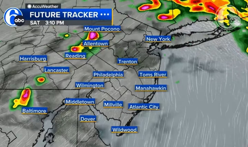
Even Channel 6 Philadelphia sees the Tamaqua Split...


-
1
-
-
So, will tomorrow's high severe chances finally overcome the Tamaqua Split?
Central PA Summer 2026 Discussion/Obs Thread
in Upstate New York/Pennsylvania
Posted
I can't seem to tolerate "extremes" on either side of the calendar anymore. Cold always bothered me, but now summer heat and humidity does as well.
I probably should move to San Diego.