

Voyager
-
Posts
11,038 -
Joined
Content Type
Profiles
Blogs
Forums
American Weather
Media Demo
Store
Gallery
Posts posted by Voyager
-
-
8 minutes ago, Rd9108 said:
He didn't see this yet

Solid...
-
13 minutes ago, TimB said:
Just thought 2024 would be different.
It's only January 1st for Christ's sake...
-
 2
2
-
-
You guys need to slow down on your posting. You're going to turn this potential snowstorm into a rainstorm...

-
 2
2
-
-
6 minutes ago, GrandmasterB said:
Impressive 6Z euro output. My goodness.
What did it show? I don't pay for premium, so I can only see the 0z and 12z runs.
-
15 minutes ago, Blizzard of 93 said:
6z GFS snow for the 7th storm
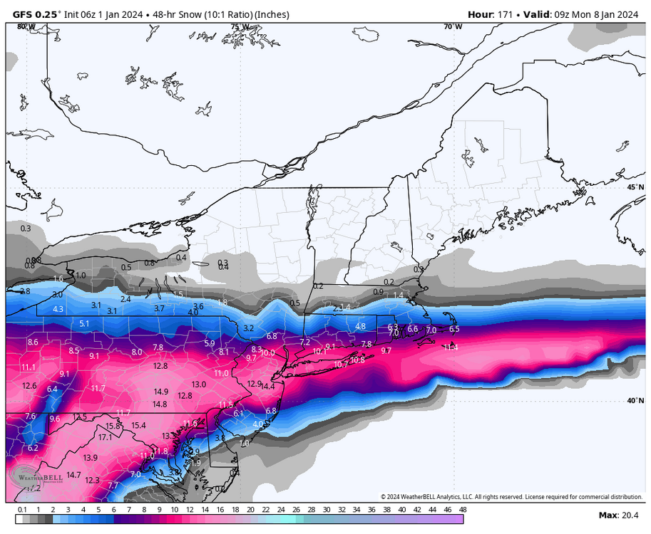
I don't know if I've ever seen a map with that kind of straight line cutoff that shuts out everyone from Buffalo to Albany to Boston and North.
Solid snowstorm for I-80 and south though.
-
1
-
-
57 minutes ago, Blizzard of 93 said:
70s…is this @Voyager forecast?
In all honesty, we aren't going to sniff 70 for quite awhile as a cool regime locks in for awile out here.
-
3 hours ago, Bubbler86 said:
This is the 7th not the 8th. Plus temps are still not overly cold. Snowing in the MA (MD, N VA) but 2M temps are above freezing for some of them. Philly near 32, LSV 25-30 during the height of the snow.
25 to 30 are perfect snow temps. Cold enough to accumulate, but not to cold to go out and enjoy it.
-
1
-
-
25 minutes ago, Jns2183 said:
Isn't Flagstaff above there yearly snow average already?
Sent from my SM-G970U using Tapatalk
Not sure.
-
24 minutes ago, mahantango#1 said:
I think the guys in here are ready to form a posse to get you back home and hold a tribunal on the several lost winters that you have denied them.
I know. I'm legit worried about even flying back for a visit...


-
1
-
-
21 minutes ago, mahantango#1 said:
Seems like the models just want to keep pushing the heart of winter back. Should we be thinking of getting the punting team back out on the field on 1st down?
I'm telling you, winter won't return to PA until I do. Wherever I am, there too shall the cold be. Look at last year. Coolest and wettest winter in the southwest in over a decade.
And back when I was trucking coast to coast, whatever side of the country I was at was where a trough had set up. When I was in California you were warm and dry and I was cold and rainy/snowy. Then, when I was home, the west was warm and dry, and PA was cold and rainy/snowy.
Mother Nature hates me...

-
4
-
-
11 minutes ago, Bubbler86 said:
Merry Christmas.
42 7:00Am Nooners.

5:00AM Arizona nooners. 40 degrees.
-
1
-
-
7 minutes ago, Bubbler86 said:
Pittsburgh Special for that last vort on the 6Z GFS. Op and ensembles keep insisting we will have something.

Wet or white, that storm would be a beast...
-
1
-
-
35 minutes ago, Blizzard of 93 said:
6z GFS looks cold enough for snow from NYE onward with a few storms that miss to our southeast this run.
I’d much rather see this than seeing storms heading for the Great Lakes.
Again, we should have our chances.
I agree with you. Suppressed storms can and do trend west and slam the region. Cutters never seem to trend east. One they cut, they never seem to come back.
-
1
-
-
1 minute ago, Atomixwx said:
And he wants to be the Maude...
Edit: Goddamnit, I just saw his response. I'm a dick.
Sent from my motorola edge 5G UW (2021) using Tapatalk
Don't feel bad. I almost made a similar post, but saw why he's there. Sorry for your loss @canderson
-
 1
1
-
-
Seriously???
PA or AZ, it makes no difference to the weather gods.

-
1
-
-
9 minutes ago, paweather said:
Your in Zona right?
Yeah, but I want you all to get snow. I just couldn't resist tossing that out there...lol
-
2
-
-
44 minutes ago, mitchnick said:
Don't look now, but 2/10 just walked in the door. Sharp north cut-off included.
.thumb.png.c4f2baee42d5a90a43e533c7ba10f906.png)
That shafts Tamaqua. Toss it...
-
6 minutes ago, canderson said:
I volunteer
Honestly, you're who I had in mind. I think you'd be a good mod.
-
1
-
-
3 minutes ago, canderson said:
This homophobic language is unacceptable. Grow up or leave.
The guy needs a timeout, and this sub needs a dedicated, resident moderator.
-
So now I get to deal with the Phoenix Split...


-
1
-
-
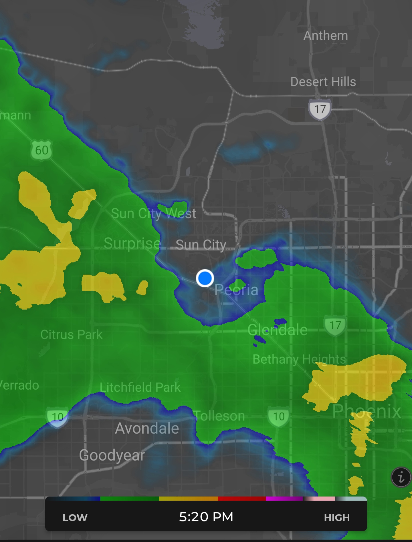
.34" in the desert rain gauge so far this morning, and if everyone is right, it's going to continue all day. A true Sonoran Soaker as they call them out here...
I'll update more later.
-
13 minutes ago, Bubbler86 said:
I cannot believe Office Depot is still kickin.
I believe they merged with Office Max.
-
1
-
-
2 hours ago, canderson said:
Happy Solstice. Can we get some f'n snow PLEASE???
I have to say that, for now anyway, I actually enjoy the first day of winter.
Added benefit. On this new Office Depot account I drive on, I only go to Tucson, and then to Tempe. No more Flagstaff snow for me!

-
4
-
-
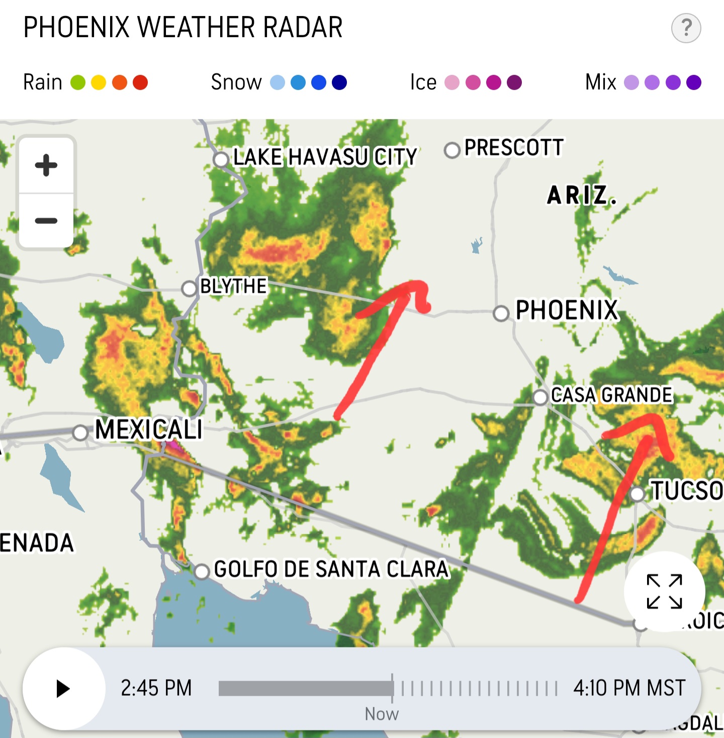
Setting up to be a soggy desert this weekend for me. Pretty impressive rain event as far as Phoenix is concerned.
Thursday NightA 50 percent chance of showers after 11pm. Increasing clouds, with a low around 56. East northeast wind around 5 mph. New precipitation amounts between a tenth and quarter of an inch possible.FridayShowers, with thunderstorms also possible after 11am. High near 63. East wind 5 to 10 mph. Chance of precipitation is 100%. New rainfall amounts between three quarters and one inch possible.Friday NightShowers. Low around 52. East southeast wind 5 to 10 mph becoming south southwest after midnight. Chance of precipitation is 100%. New precipitation amounts between a quarter and half of an inch possible.SaturdayShowers likely. Mostly cloudy, with a high near 62. Southwest wind 5 to 10 mph. Chance of precipitation is 70%. New precipitation amounts between a tenth and quarter of an inch possible.-
2
-


.png.3425e6f25611383000088b16814b0723.png)
Central PA Winter 23/24
in Upstate New York/Pennsylvania
Posted
CTP seems fairly confident for a storm nearly a week away. Of course this is subject to change, but seeing likely and 70% chance this far out is intriguing.
For Tamaqua: