wxsniss
-
Posts
5,788 -
Joined
-
Last visited
Content Type
Profiles
Blogs
Forums
American Weather
Media Demo
Store
Gallery
Everything posted by wxsniss
-
March 12/13/14 Blizzard/Winter Storm/WWA etc
wxsniss replied to Bostonseminole's topic in New England
And quickly. You can see how quickly roads get covered after they get plowed. Helps that we cooled to upper 20s too. -
March 12/13/14 Blizzard/Winter Storm/WWA etc
wxsniss replied to Bostonseminole's topic in New England
Agree... just probably more out between 128-495 -
March 12/13/14 Blizzard/Winter Storm/WWA etc
wxsniss replied to Bostonseminole's topic in New England
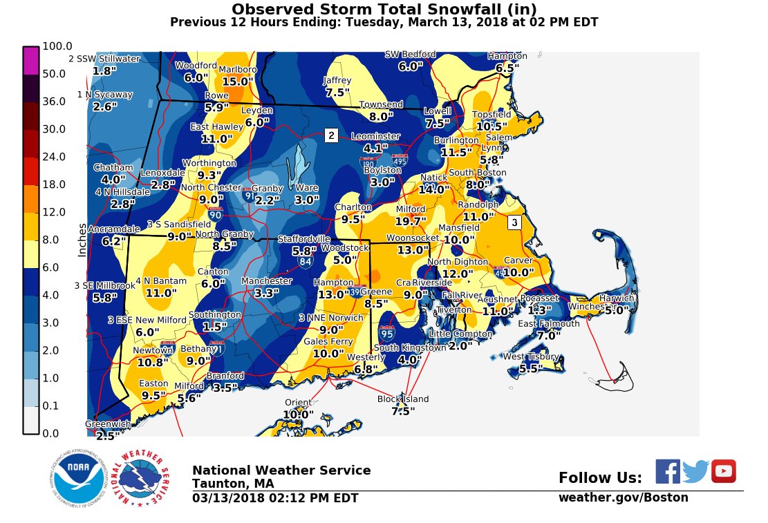
18z RAP run gave Boston area another 4-6"... that band, though less robust, looks decent and will deliver. Intensity and flakes already improving. When all is said and done Boston area will probably end up 11-15"... nothing to complain about... is great by Sunday's expectations, and only by yesterday's 20"+ runs does it seem like a bust -
March 12/13/14 Blizzard/Winter Storm/WWA etc
wxsniss replied to Bostonseminole's topic in New England
Remnants of mega band have breached 495 wall... ticking east... I think by 4pm Boston area will be singing a different tune -
March 12/13/14 Blizzard/Winter Storm/WWA etc
wxsniss replied to Bostonseminole's topic in New England
Probably does not include the Worcester area post-deathband
-
March 12/13/14 Blizzard/Winter Storm/WWA etc
wxsniss replied to Bostonseminole's topic in New England
We lost at least 6"... We'll still pass a foot in Boston... those bands gotta exit somehow -
March 12/13/14 Blizzard/Winter Storm/WWA etc
wxsniss replied to Bostonseminole's topic in New England
About as sharp winners and losers as you can get... it's coming down in Boston metro but snowgrowth is awful We know these bands must come east, question is in what state and rate -
March 12/13/14 Blizzard/Winter Storm/WWA etc
wxsniss replied to Bostonseminole's topic in New England
Banding delivered... 8+ hours to go? -
March 12/13/14 Blizzard/Winter Storm/WWA etc
wxsniss replied to Bostonseminole's topic in New England
I wish we could dissect and explain mechanistically each one of these bands, some awesome processes underway -
March 12/13/14 Blizzard/Winter Storm/WWA etc
wxsniss replied to Bostonseminole's topic in New England
Boston folks that mega band to our northwest looks to be decaying and maybe reforming over Worcester? We'll get our turn... all that will collapse over us, and in the meantime watch that sharp process to our east incoming... -
March 12/13/14 Blizzard/Winter Storm/WWA etc
wxsniss replied to Bostonseminole's topic in New England
Jay that very sharp feature is interesting, looks to correlate well with northwest edge of H7 frontogenesis? -
March 12/13/14 Blizzard/Winter Storm/WWA etc
wxsniss replied to Bostonseminole's topic in New England
Mega band just outside of 128 has signs of expanding east into metro Boston... -
The August 21, 2017 Great American Eclipse
wxsniss replied to ice1972's topic in Weather Forecasting and Discussion
Kohx afd catching up to the model trends mentioned earlier... adding in chance of some cirrus blow off of storms in Mississippi valley. Not the end of the world given soupy airmass, and still think there's room for this to trend great vs. good for BNA. I feel like it's January writing this: we want that 0z Fri GFS / Euro solution back! -
The August 21, 2017 Great American Eclipse
wxsniss replied to ice1972's topic in Weather Forecasting and Discussion
Was thinking of photos with black hole in the sky behind... how will you angle your camera? The sun will be nearly overhead (vs. those shots you see with the eclipse near the horizon). -
The August 21, 2017 Great American Eclipse
wxsniss replied to ice1972's topic in Weather Forecasting and Discussion
Key word might be "surprisingly" lol... I'm quite giddy. I'll PM you my cellphone #. Packing includes hardcopy road maps assuming cellular service will be inundated. Picking up rental at BNA, have to also pick up my brother, then we will head to motel in downtown Nashville. Not sure we will trial run to Gallatin though I'd definitely do that if I were alone. Monday AM early wakeup, plan to leave for Gallatin by 9-9:30am, and will adjust earlier if crowds are obviously insane Sunday night. Reminder for everyone to turn off cellphone service / texting etc so as not to get annoying distractions during eclipse. My only plan is to video record ~ 10 min of event on my iphone. Nothing distracting, no practice needed, no messing around with camera settings. Otherwise just taking in every second of the experience. -
The August 21, 2017 Great American Eclipse
wxsniss replied to ice1972's topic in Weather Forecasting and Discussion
Not sure how these cloud prediction algorithms are done... weather.us and pivotalweather GFS trended cloudier for BNA area, entirely high clouds, though ridge placement looks about the same as the best run 0z Fri for GFS + Euro. Kohx sounded optimistic this morning, scattered ci + diurnal cu. I think we are in good vs. great territory. We'll take it and hope it trends even better in next day! -
The August 21, 2017 Great American Eclipse
wxsniss replied to ice1972's topic in Weather Forecasting and Discussion
Jerry, check out kohx afd -
The August 21, 2017 Great American Eclipse
wxsniss replied to ice1972's topic in Weather Forecasting and Discussion
Entering 96 hour timeframe on globals for 18z Monday. Nashville looking good, Fella. GFS / CMC decent, Euro could be better. Steady as she goes. AFD: "Monday, eclipse day, looks like a typical August day. It will be hot and humid. The morning may begin with total sunshine, then as afternoon arrives, we will likely see some diurnal cumulus clouds form as patches of thin cirrus move overhead. The best news is that pops look very low with a prevailing upper level ridge. The updated forecast will show 20 pops across the south half and less than 15 percent over the north. Overall, we are optimistic about seeing the eclipse, but it will probably not be perfect, and viewers may have to deal with some annoying patchy clouds. " I'm hoping we can dry this out a little more. -
The August 21, 2017 Great American Eclipse
wxsniss replied to ice1972's topic in Weather Forecasting and Discussion
3:33-->5:20pm Jetblue, direct flight -
The August 21, 2017 Great American Eclipse
wxsniss replied to ice1972's topic in Weather Forecasting and Discussion
I have to check with my brother. It's his first time in Nashville and he had ambitious hopes to enjoy the music scene / honky-tonk bars / Opryland etc Sunday night. If we do meet up, the Vanderbilt area would be perfect. My flight from Logan gets in around 5:30pm. -
The August 21, 2017 Great American Eclipse
wxsniss replied to ice1972's topic in Weather Forecasting and Discussion
We should! To clarify, I'm staying at a "random motel in the city" meaning in downtown Nashville. So plan to drive up to Gallatin Monday morning depending on traffic. Will have to make contingency plans based on clouds / traffic. Yeah Euro / CMC / GFS have held decent. At least no large scale synoptic system to mess it up, with a decent southeast ridge and high pressure. -
The August 21, 2017 Great American Eclipse
wxsniss replied to ice1972's topic in Weather Forecasting and Discussion
With my brother. I gather you will be with family? On your recommendation a while back, I reserved 2 tix to the Gallatin event. We are staying in some random motel in the city Sunday night, then plan to stage early Monday morning. But I'm a little nervous about making return flights at 5pm. Normal drive from Gallatin to BNA ~45 min, so figure we will have 2 hours heading back at 2pm. Traffic warnings sounds apocalyptic. I read that a group of 300 Japanese tourists made reservations to Gallatin a year ago, so extrapolate from that. Was also unclear to me how we get to the soccer fields that are the "main viewing area", and how that relates to the concerts etc... my preference is minimal light pollution and minimal obstruction of the horizons, which an open field (or elevated point) could achieve. But even if traffic and parking is a complete disaster, looks like plenty of options to improvise: -
The August 21, 2017 Great American Eclipse
wxsniss replied to ice1972's topic in Weather Forecasting and Discussion
That Sperling's Eight Second Law is a good read, thanks for that! I think my only photography, at most, will be 10 min video capturing before / during / after just to document that I was there. So I don't have to pay attention to the camera, but it will record. Heading to Nashville, TN. Not sure yet where to stage. My biggest concern is light pollution from photovoltaic streetlights or businesses going on automatically. wxeyeNH... any other tips to maximize the experience? Urban rooftop vs. open field? Video vs. still shots (of surroundings, again, I don't think my own photos of the eclipse will be worthwhile)? Anything else you would recommend? Thanks for sharing! -
The August 21, 2017 Great American Eclipse
wxsniss replied to ice1972's topic in Weather Forecasting and Discussion
Hey guys, I'm Nashville TN bound, bought tix weeks ago worried they would sell out. If I had my choice, I'd go to Idaho or Wyoming for best chances of clear sky and scenery. Will make an audible on where to set base in Nashville area. The good thing is even if traffic / infrastructure is totally shut down, anywhere in Nashville including airport will be in totality. -
The August 21, 2017 Great American Eclipse
wxsniss replied to ice1972's topic in Weather Forecasting and Discussion
Booked to Nashville. Staying in a motel just east of the city (~ 2 min totality), and figure I'll either see it from the motel (if traffic is horrendous) or drive several hours before and wait north of the city (~2:40 totality). Potentially once-in-a-lifetime bucket list item. And when will this happen again in such easy travel... 1:30pm in the afternoon... in August... Jerry I'm happy to hear you're doing this. Hope we get clear skies. People describe this as pretty divine. Anyone have tips on how to experience it? I'm thinking tips like positioning away from street-lights that might go on automatically. What to capture? Photos? Movie of the entire thing?