wxsniss
-
Posts
5,787 -
Joined
-
Last visited
Content Type
Profiles
Blogs
Forums
American Weather
Media Demo
Store
Gallery
Everything posted by wxsniss
-
To be precise... SLP is actually west of 0z... 966-67 crawling parallel to elbow, ~20-30 miles west of 12z 973-974
-
Definitely better than 6z Ray... any bleeding has stopped
-
thru 42h this looks to land somewhere between 6z and 0z runs
-
thru 30h southern energy better, trough axis a bit better... vs. TPV a tic more stout... we'll see how that balances...
-
Thru h18... differences mostly within noise... southern and northern streams slightly better than 6z, PV a hair more stout... but all very slight
-
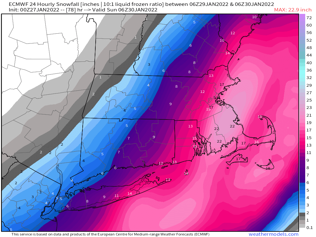
Box map updated tonight These amounts will likely be expanded and increased Thursday if there is no support for the GFS
-
Yeah I was thinking this was going to be a Cape scraper from early signs In any case, a solid rejection of the far east GFS, along with the big UK/GGEM jumps Despite the confluence, Euro takes a more northeasterly track once it's captured... spreads the goods better up ME coast Good track for a deform band interior eastern MA

-
Thankfully got rid of that dual low nonsense it had earlier
-
thru 36h, perhaps the biggest improvement is in the TPV more restrained glad to see that, that was a more recent fly in the ointment
-
Yeah this should come west And agree, 18z Euro was already pretty west
-
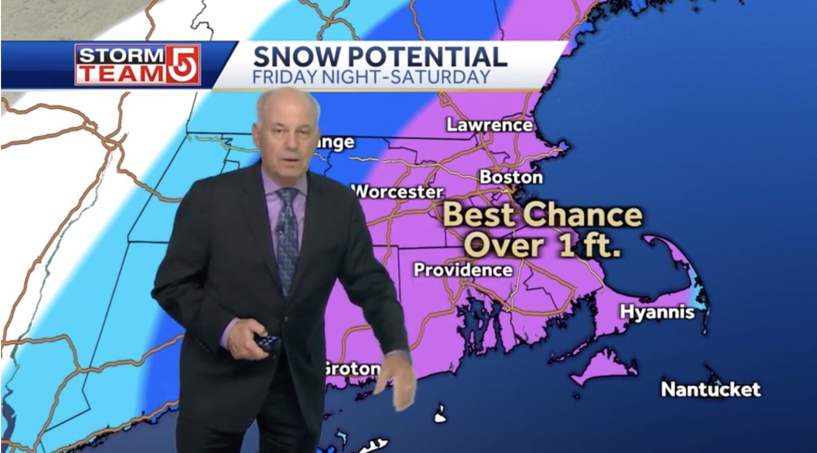
Harv for the fans... 1 foot pushed past Worcester 1 foot+, "potentially much above" in eastern MA

-
Terrible run and can't dismiss this 0z Euro is critical
-
Thru 33hr GFS southern energy about the same, maybe a tic east Biggest difference is in trough, looks to dig better with northern stream
-
The single takeaway from this run is that NAM is not yet reliable or informative for this system Euro/GFS/EPS blend until further notice
-
hr 48 that runaway convection that was to Bermuda 18z is gone will 100% be better than 18z, but that's a low bar lol, so we'll see how this unfolds again, key message is 18z was an anomaly
-
Yep hr33-39 can already see the shortwave tugging much better on the trough... if all the associations we've observed this week mean anything, this will definitely be a better hit
-
Hr 33... southern shortwave more east... TPV more restrained... this should be a better run Main value is to reassure everyone that 18z NAM was an anomaly, not a trend
-
Trend this on all the GFS runs today... slowly ticking more stout with every run Not sure if this is what ORH / CoastalWx are referring to, but it's definitely blunting the trough sharpness. A more robust northern energy and sooner interaction with southern energy can definitely overcome this negative, but something to watch.
-
Trough and shortwaves actually looked more favorable... continued capture by 21z Saturday... but surface tic'ed east I actually thought surface should look better than depicted (same for 12z run) 18z NAM still tossed
-
Thru 39h, 18z GFS looks like it will be better than 12z... southern energy dragging less, northern energy more robust, trough structure more favorable
-
Same. A number of coworkers/friends/family counting on my forecasts. For now, we hold. Some are too quick to forget: 12z NAM 6 hrs ago was a huge hit. 12z Euro/GFS (more reliable than NAM at this range) were big hits for SNE. No overreactions and we wait at least until 0z for more clarity.
-
Outer Cape barely reaches warning lol
-
I mean this is flurries eastern SNE thru 03z Sunday... huge discontinuity from 6z and 12z runs, I would not over-react to this
-
Big discontinuity on this 18z NAM... huge swing from 6z-12z-18z... wouldn't over-react to this
-
Thru 54 Southern energy is dragging, entire trough looks a bit more progressive On the plus side, the northern energy looks more robust