MoWeatherguy
-
Posts
2,322 -
Joined
-
Last visited
About MoWeatherguy

- Birthday December 15
Recent Profile Visitors


-
MO/KS/AR/OK 2025-2026 Winter Discussion
MoWeatherguy replied to stormdragonwx's topic in Central/Western States
Yah I see I'm all snow here finally. This has been a total wreck of a forecast. -
MO/KS/AR/OK 2025-2026 Winter Discussion
MoWeatherguy replied to stormdragonwx's topic in Central/Western States
Anybody else see this from NWS TUL? Sounds like this might continue to be a sleet parade south of I 44 most of the night. .SHORT TERM... (The rest of tonight) Issued at 805 PM CST Sat Jan 24 2026 Analysis of water vapor imagery reveals a robust upper level low entering Texas this evening. The GLM shows numerous cloud flashes in the convection wrapping around this low, which will later eject northeastward into the forecast area as its absorbed into the main upper level trough. In the meantime, confluent mid level flow at 700 hPa is supporting frontogenesis to the west of the forecast area. Widespread upper level diffluence and increase potential vorticity advection is also noted. Cooling cloud tops and expanding precipitation within the frontogenetical zone are already occurring. Meanwhile, fairly deep moisture continues to stream into the area from the south ahead of the upper level low. These factors should support a consolidation of the numerous showers into a broad precipitation shield with embedded areas of convection. Widespread moderate to locally heavy precipitation will develop through the early overnight hours before gradually diminishing during the day Sunday. Snow will be favored along the I-44 corridor, with a mixture of snow and sleet down to just south of the I-44 corridor, and sleet to the south of there. Total snow and sleet will be highly variable but significant. The hardest hit areas could see up to 10 inches of snow or 2 inches of sleet, though most will see somewhat lower totals. -
MO/KS/AR/OK 2025-2026 Winter Discussion
MoWeatherguy replied to stormdragonwx's topic in Central/Western States
Thanks, all. -
MO/KS/AR/OK 2025-2026 Winter Discussion
MoWeatherguy replied to stormdragonwx's topic in Central/Western States
For you folks with more met knowledge out there, where is this warm nose located? 3000 ft? 4000? Where can I see a map of that? Is it 750 MB? -
MO/KS/AR/OK 2025-2026 Winter Discussion
MoWeatherguy replied to stormdragonwx's topic in Central/Western States
Wasting a lot of precip on this crazy sleet. All sleet here since mid-afternoon. SMH -
MO/KS/AR/OK 2025-2026 Winter Discussion
MoWeatherguy replied to stormdragonwx's topic in Central/Western States
Hopefully an overachieving performance yet to come -
MO/KS/AR/OK 2025-2026 Winter Discussion
MoWeatherguy replied to stormdragonwx's topic in Central/Western States
The HRRR is pretty impressive for the next 36 hrs so there's still a chance we get close to double digits. The dry air robbed us some last night, but still picked up 2" here in far NW AR. This won't be a top 10 snow but will be a very nice one when all is said and done. Probably get us to our seasonal average here. -
MO/KS/AR/OK 2025-2026 Winter Discussion
MoWeatherguy replied to stormdragonwx's topic in Central/Western States
18z GFS has amped up snowfall some from its 12z run. -
MO/KS/AR/OK 2025-2026 Winter Discussion
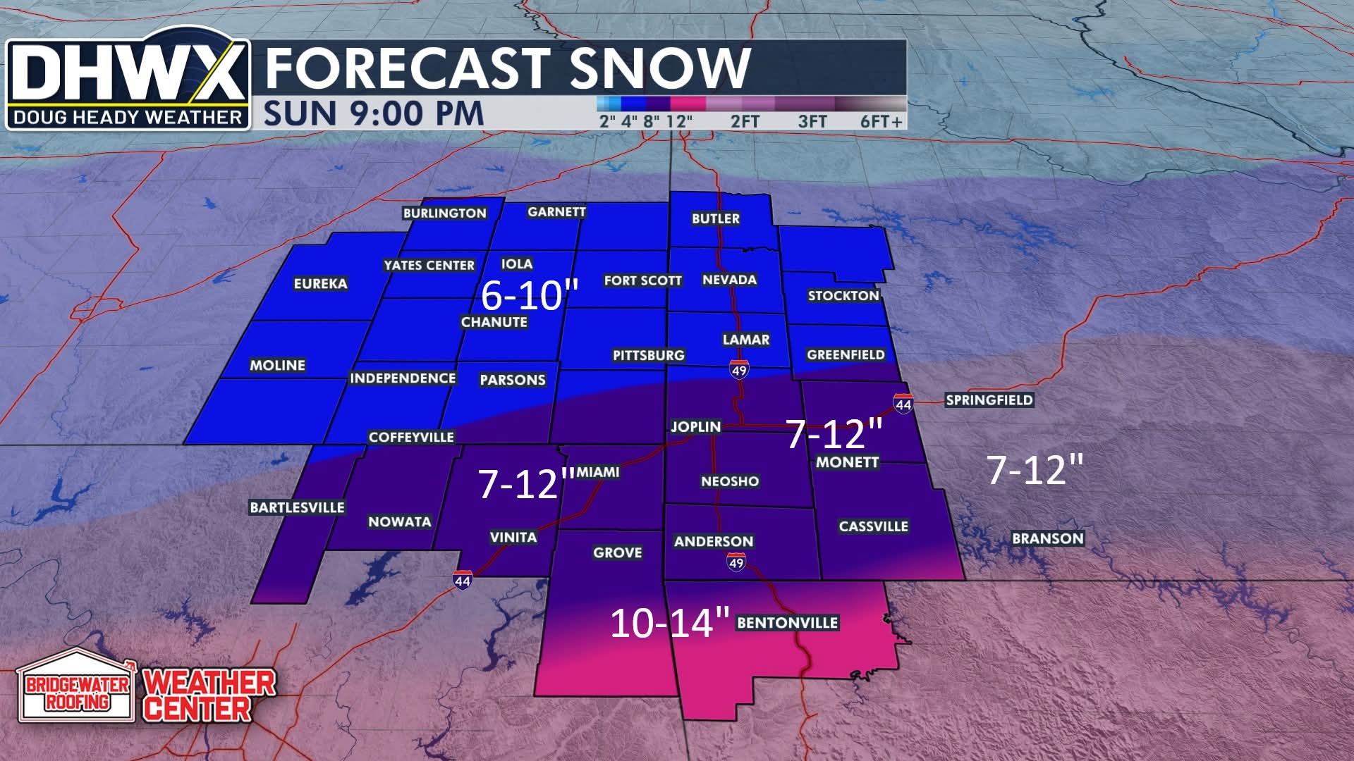
MoWeatherguy replied to stormdragonwx's topic in Central/Western States
Maybe this is not a copyright infringement but here is Doug Heady latest forecast. I've always respected him as a reliable forecaster in this area. He's started his own private company now.
-
MO/KS/AR/OK 2025-2026 Winter Discussion
MoWeatherguy replied to stormdragonwx's topic in Central/Western States
Crazy stuff. Maybe this is gonna be a wallop this time. -
MO/KS/AR/OK 2025-2026 Winter Discussion
MoWeatherguy replied to stormdragonwx's topic in Central/Western States
It does appear the globals are all showing a pretty sharp cutoff around and just north of 44. The heaviest precip zones appear to be locking in on E and NE OK, all of NW AR, and far S MO. If the upper temp profiles hold just right this entire area should get slammed. -
MO/KS/AR/OK 2025-2026 Winter Discussion
MoWeatherguy replied to stormdragonwx's topic in Central/Western States
From what I can tell it looks like most models have seen a slight uptick in overall QPF at 0z. Good sign. That warm nose will be the wildcard for most of the Arkansas crowd. -
MO/KS/AR/OK 2025-2026 Winter Discussion
MoWeatherguy replied to stormdragonwx's topic in Central/Western States
Is this crap really real or are the models just all reading something wrong?? -
MO/KS/AR/OK 2025-2026 Winter Discussion
MoWeatherguy replied to stormdragonwx's topic in Central/Western States
Yah let's cut that in half I'll take it -
MO/KS/AR/OK 2025-2026 Winter Discussion
MoWeatherguy replied to stormdragonwx's topic in Central/Western States
0z NAM still laying the hammer down.