

Burghblizz
-
Posts
1,742 -
Joined
-
Last visited
Content Type
Profiles
Blogs
Forums
American Weather
Media Demo
Store
Gallery
Everything posted by Burghblizz
-

Western PA/Pittsburgh Winter 2021/22 Discussion
Burghblizz replied to meatwad's topic in Upstate New York/Pennsylvania
Speaking of freshening things up - NAM is looking more robust (some 3’s and 4’s) for extreme southern parts of Western Pa for late Wed night. Maybe it can lead the way to one more jump north. -
Western PA/Pittsburgh Winter 2021/22 Discussion
Burghblizz replied to meatwad's topic in Upstate New York/Pennsylvania
Clippers don’t quite have the excitement of the chase or high ceiling - but certainly can be nice when you start with a good snowpack -
Western PA/Pittsburgh Winter 2021/22 Discussion
Burghblizz replied to meatwad's topic in Upstate New York/Pennsylvania
Euro ensembles had some nice Piedmont runners -
Western PA/Pittsburgh Winter 2021/22 Discussion
Burghblizz replied to meatwad's topic in Upstate New York/Pennsylvania
Nice band coming through with some blowing snow. A little Icing on the cake. -
Western PA/Pittsburgh Winter 2021/22 Discussion
Burghblizz replied to meatwad's topic in Upstate New York/Pennsylvania
‘93 of course. Westmoreland and Fayette had them during the second (smaller) storm in February 2010. While the totals were more modest than the first one, the winds were howling. Before ‘93, it would have been one of the Jan ‘78 storms. And before that, Nov ‘50, unless one of those bigger ones in the 60’s had the criteria. But of course those days were different as far as warnings and criteria. But I’d say that’s a quarter century type happening. -
Western PA/Pittsburgh Winter 2021/22 Discussion
Burghblizz replied to meatwad's topic in Upstate New York/Pennsylvania
I moved to Cranberry this past year (SW corner of Butler county, but only a few miles from Beaver border). No, snow wasn’t the reason, but being a little shielded from the WTOD was in the back of my mind :-) -
Western PA/Pittsburgh Winter 2021/22 Discussion
Burghblizz replied to meatwad's topic in Upstate New York/Pennsylvania
Based on the number of 8” and 9” reports in AGC, it definitely hit the “8 in 24 hr” warning criteria in Allegheny and certainly Beaver and Butler. The public forecasts were very much validated, even if on the low to mid side. I also thought eastern suburbs did what I thought. Just thought city and west would avoid the dry slot, but wasn’t meant to be. -
Western PA/Pittsburgh Winter 2021/22 Discussion
Burghblizz replied to meatwad's topic in Upstate New York/Pennsylvania
Nice regional breakdown of updated totals. Mostly 8+ In the immediate Pgh area. You can see our 12+ that just slid west, but also where the lower totals were SE.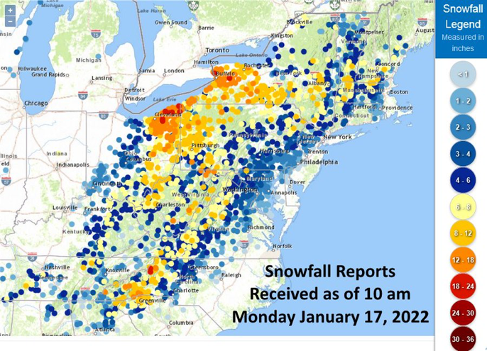
-
Western PA/Pittsburgh Winter 2021/22 Discussion
Burghblizz replied to meatwad's topic in Upstate New York/Pennsylvania
Maybe - but it can work the other way too where the measurement was where the snow drifted from. But good point as far as another reason that the numbers are all over the place. -
Western PA/Pittsburgh Winter 2021/22 Discussion
Burghblizz replied to meatwad's topic in Upstate New York/Pennsylvania
Seeing some 9 to 11” reports out east of the city up the 28 corridor towards New Ken. The orientation of the heavier reports is less to do with longitude, latitude, and elevation, and likely more to do with rates and banding. (speaking within Pgh metro that is) -
Central PA - Winter 2021/2022
Burghblizz replied to Bubbler86's topic in Upstate New York/Pennsylvania
It definitely was an important part of framing up the final result. -
Western PA/Pittsburgh Winter 2021/22 Discussion
Burghblizz replied to meatwad's topic in Upstate New York/Pennsylvania
It’s Shafer Road in Moon - which is like a mile from the airport. So it essentially mirrors what you would see there. -
Central PA - Winter 2021/2022
Burghblizz replied to Bubbler86's topic in Upstate New York/Pennsylvania
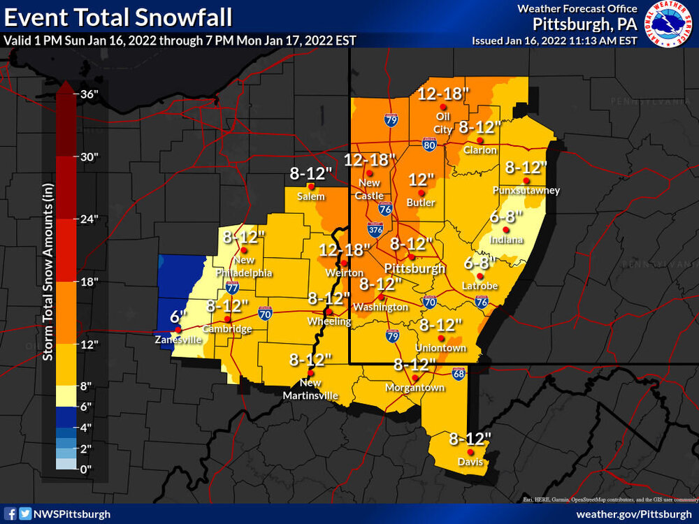
The NAM was good with showing that there were going to be P type issues even north and west - but I’m not sure I give it too much credit because a wide spread Western/west central PA ice storm really didn’t materialize. Just a lot of mixing and flipping. Most areas around Pittsburgh look to be finishing 7” to 10” once this morning tapers off. The real prolific stuff got shunted a little more west, as the WV panhandle and extreme western PA should pop some 12” totals. -
Western PA/Pittsburgh Winter 2021/22 Discussion
Burghblizz replied to meatwad's topic in Upstate New York/Pennsylvania
The radar pivot and banding last night was awesome. I can’t see that .47” at the airport being accurate, but I don’t think a 2” hour was out of the question. I caught more the tail of that same band and it was rippin. A line from Weirton to Beaver falls will break a foot. That area did better with avoiding a prolong dry slot before everything pivoted. Most of the rest of us got caught up in it a little too long. Still a beautiful morning -
Western PA/Pittsburgh Winter 2021/22 Discussion
Burghblizz replied to meatwad's topic in Upstate New York/Pennsylvania
Got a couple hours of sleep bit woke up to some great bands. (By the way, I should have taken King Weenie’s bet since NWS total is closing in on 7”, and it looks like some 30 dbz are about to rotate in there. -
Western PA/Pittsburgh Winter 2021/22 Discussion
Burghblizz replied to meatwad's topic in Upstate New York/Pennsylvania
Radar filled in finally and pivoted. Been cranking for the last couple hours in Cranberry. Just passed 5” -
Western PA/Pittsburgh Winter 2021/22 Discussion
Burghblizz replied to meatwad's topic in Upstate New York/Pennsylvania
Dumping - back to all snow in Cranberry. 2.5” and .5” fresh during the 20 min I was just walking the dog -
Central PA - Winter 2021/2022
Burghblizz replied to Bubbler86's topic in Upstate New York/Pennsylvania
It’s ripping here, despite what K-weenie sells. Been occasionally mixing, but heavy snow at the moment and still early on. -
Western PA/Pittsburgh Winter 2021/22 Discussion
Burghblizz replied to meatwad's topic in Upstate New York/Pennsylvania
As far as actual weather and not the weenie fest… When you have a strong 925 jet advecting into cold air, you have the recipe for some intense rates. But might have to flirt with some sleet to get it. -
Western PA/Pittsburgh Winter 2021/22 Discussion
Burghblizz replied to meatwad's topic in Upstate New York/Pennsylvania
Heavy snow in Cranberry. 24 degrees. Wind driven smaller flakes have turned to big fatties -
Western PA/Pittsburgh Winter 2021/22 Discussion
Burghblizz replied to meatwad's topic in Upstate New York/Pennsylvania
More wind driven and powdery than I was expecting to begin with -
Western PA/Pittsburgh Winter 2021/22 Discussion
Burghblizz replied to meatwad's topic in Upstate New York/Pennsylvania
One cat basically so weenied out that it makes it MA thread vibe. But they have like 20 like that -
Western PA/Pittsburgh Winter 2021/22 Discussion
Burghblizz replied to meatwad's topic in Upstate New York/Pennsylvania
-
Western PA/Pittsburgh Winter 2021/22 Discussion
Burghblizz replied to meatwad's topic in Upstate New York/Pennsylvania
Keep those southern obs coming -
Western PA/Pittsburgh Winter 2021/22 Discussion
Burghblizz replied to meatwad's topic in Upstate New York/Pennsylvania
If we can avoid the snow cone, the blowing and drifting might be understated to this point


