Burghblizz
-
Posts
1,742 -
Joined
-
Last visited
Content Type
Profiles
Blogs
Forums
American Weather
Media Demo
Store
Gallery
Everything posted by Burghblizz
-

Western Pa / Pittsburgh area Winter Discussion ❄️☃️
Burghblizz replied to north pgh's topic in Upstate New York/Pennsylvania
GFS bringing 2”- 4” into the Mon Valley Sunday. So not quite dead yet for at least some accum -
Western Pa / Pittsburgh area Winter Discussion ❄️☃️
Burghblizz replied to north pgh's topic in Upstate New York/Pennsylvania
I admit I was kind of excited in ‘94 to get to -22. Felt like I was seeing history and so I definitely rooted for it. But I can probably take or leave extreme cold at this point. -
Western Pa / Pittsburgh area Winter Discussion ❄️☃️
Burghblizz replied to north pgh's topic in Upstate New York/Pennsylvania
2009 and 2015 saw double digits below zero officially. -
Western Pa / Pittsburgh area Winter Discussion ❄️☃️
Burghblizz replied to north pgh's topic in Upstate New York/Pennsylvania
A significant shift is doable because we are talking about phase/no phase and the timing. So I wouldnt be suprised if it jumps one way or another in the next 24 hours of models -
Western Pa / Pittsburgh area Winter Discussion ❄️☃️
Burghblizz replied to north pgh's topic in Upstate New York/Pennsylvania
Final official total was 8.5”. Felt like less in most places due to long duration and compacting - but NWS does a good job counting every inch properly. Credit on their forecast too. This was a pain, but 6-8” over 48 hours was a good call. (if we catch a band later, not sure we can count it ) -
Central PA - Jan 31 to Feb 2 Winter Storm
Burghblizz replied to MAG5035's topic in Upstate New York/Pennsylvania
We wound up with around 7”. Same main issue getting the intial batch going. -
Western Pa / Pittsburgh area Winter Discussion ❄️☃️
Burghblizz replied to north pgh's topic in Upstate New York/Pennsylvania
Still sends SLP up the Piedmont to the Delmarva. It closes off too late (compared to yesterday) and doesn’t have an expansive shield. But the players are there. -
Western Pa / Pittsburgh area Winter Discussion ❄️☃️
Burghblizz replied to north pgh's topic in Upstate New York/Pennsylvania
There is a much more consolidated batch entering eastern Allegheny county. Not sure everything behind it holds together, but looks like the best shot at some more steady snow. Also, nice vertical lake enhanced band in central Ohio. Never seen WWA in vertically stacked counties like that - lol. Not the greatest storm for us, but still doing some interesting things. -
Western Pa / Pittsburgh area Winter Discussion ❄️☃️
Burghblizz replied to north pgh's topic in Upstate New York/Pennsylvania
I mean “technically” 2.2003 and 2.2010 were Miller B’s. But they also had a huge primary storm with a great track prior to hitting blocking. We also had a nice one in 12.2003, and probably a few others. But I really don’t like the textbook exploding Miller Bs for our area. -
Western Pa / Pittsburgh area Winter Discussion ❄️☃️
Burghblizz replied to north pgh's topic in Upstate New York/Pennsylvania
Same - looks like some are making some progress. Overall will crack 40” today with more opportunities in the pipeline -
Western Pa / Pittsburgh area Winter Discussion ❄️☃️
Burghblizz replied to north pgh's topic in Upstate New York/Pennsylvania
A Hard fought 3.3” so far officially as of 7:00 -
Western Pa / Pittsburgh area Winter Discussion ❄️☃️
Burghblizz replied to north pgh's topic in Upstate New York/Pennsylvania
2010 didn’t quite have the extreme ‘93 and 94 rates (3-4” hour), but it have some have prolonged really good rates. I remember getting like 8” in 5 hours from 7 to midnight. And then there was another period from like 3 to 6 AM where we tacked on another 5” -
Western Pa / Pittsburgh area Winter Discussion ❄️☃️
Burghblizz replied to north pgh's topic in Upstate New York/Pennsylvania
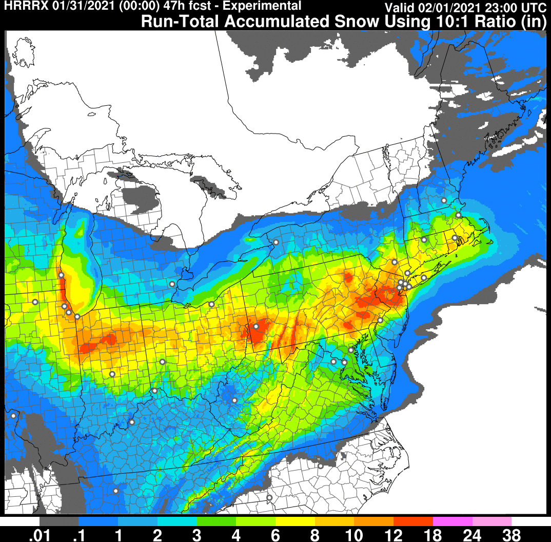
I like this look from the HRRR for this evening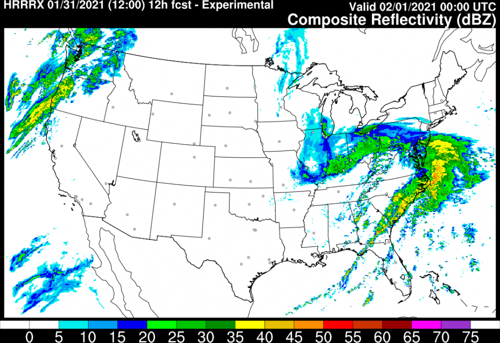
-
Western Pa / Pittsburgh area Winter Discussion ❄️☃️
Burghblizz replied to north pgh's topic in Upstate New York/Pennsylvania
All good! I know you weren’t really tracking this one the whole time, but this is the way it’s been really the last few days. It’s always been kind of a long duration, moderate event, with this outside shot of scoring big. -
Western Pa / Pittsburgh area Winter Discussion ❄️☃️
Burghblizz replied to north pgh's topic in Upstate New York/Pennsylvania
It was more like 24 hrs - but it also had some nice bursts. Hoping the same here -
Central PA - Jan 31 to Feb 2 Winter Storm
Burghblizz replied to MAG5035's topic in Upstate New York/Pennsylvania
Kpitsnow and his complaints. -
Central PA - Jan 31 to Feb 2 Winter Storm
Burghblizz replied to MAG5035's topic in Upstate New York/Pennsylvania
You can have him -
Western Pa / Pittsburgh area Winter Discussion ❄️☃️
Burghblizz replied to north pgh's topic in Upstate New York/Pennsylvania
She was saying that on Twitter too. We’ll see if it materializes. We didn’t come out guns blazing this time, but still will be interesting. About an inch or so in Monroeville. Relatively windy with this current burst -
Western Pa / Pittsburgh area Winter Discussion ❄️☃️
Burghblizz replied to north pgh's topic in Upstate New York/Pennsylvania
HRRR still likin us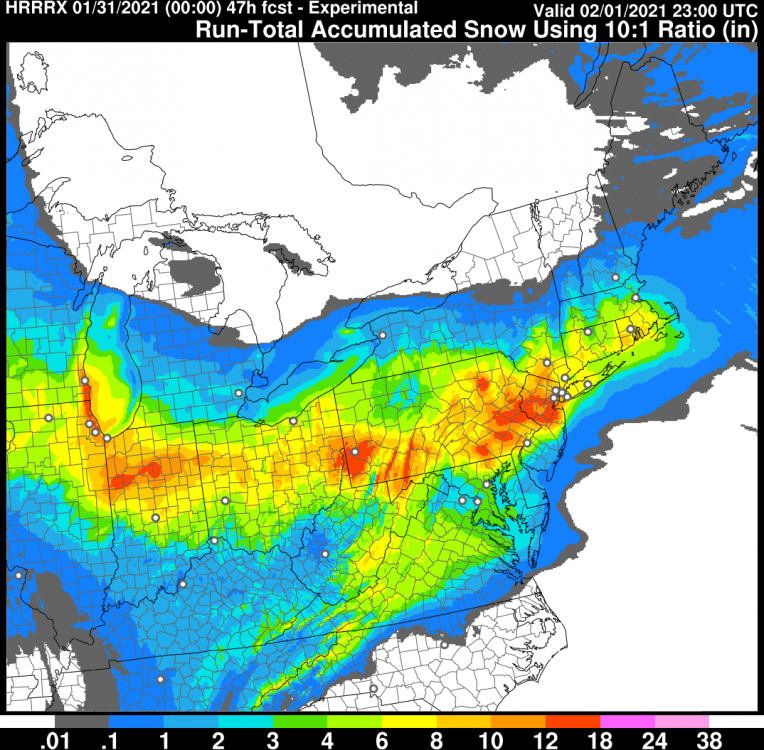
-
Western Pa / Pittsburgh area Winter Discussion ❄️☃️
Burghblizz replied to north pgh's topic in Upstate New York/Pennsylvania
This is not news. It’s always been trying to get a nice front end, and then see how the coastal develops over the second 24-36 hour period. This version of the NAM didn’t produce the way some others have. The other thing we have been watching is the heaviest intial band slipping a bit south. This NAM shows that a bit too. -
Central PA - Jan 31 to Feb 2 Winter Storm
Burghblizz replied to MAG5035's topic in Upstate New York/Pennsylvania
We’ll let yinz know how this front end is looking -
Western Pa / Pittsburgh area Winter Discussion ❄️☃️
Burghblizz replied to north pgh's topic in Upstate New York/Pennsylvania
Shift changes -
Western Pa / Pittsburgh area Winter Discussion ❄️☃️
Burghblizz replied to north pgh's topic in Upstate New York/Pennsylvania
Great analysis -
Western Pa / Pittsburgh area Winter Discussion ❄️☃️
Burghblizz replied to north pgh's topic in Upstate New York/Pennsylvania
It will be fun nowcasting the intial surge. Need to get off to a good start -
Western Pa / Pittsburgh area Winter Discussion ❄️☃️
Burghblizz replied to north pgh's topic in Upstate New York/Pennsylvania
Agree - we are in a good spot between those two mitigators (agitators). But they lurk. I like that our swath has widened. I tend to think that even though that intial heavier burst is just to the south, mixing is much more of an issue. So I’d still bet North Hills does better than South Hills, even though total QPF is lighter