

dendrite
-
Posts
63,212 -
Joined
Content Type
Profiles
Blogs
Forums
American Weather
Media Demo
Store
Gallery
Posts posted by dendrite
-
-
4 minutes ago, dryslot said:
Clocks change we go to 8pm for 0z in the spring plus having the models come out 1hr later blows this time of year.
Correct. But climo data doesn’t change. Everything still runs 5z-5z (1am-1am EDT)
-
 1
1
-
-
5 minutes ago, 40/70 Benchmark said:
GFS for MBY
19" 10:1
15" on Kutchera
3.5" PDC

PDC is always the floor. If you’re flirting with 32.5-33 with +rates tack on accordingly. I should be cold enough up here so I’m tossing it altogether.
-
lol
Gfs has 3” QPF a little east of here
-
I wonder how much more frozen Ryan will get than Kev.
-
2 minutes ago, Prismshine Productions said:
Could I hit that 16 since it mainly falls while the column is subzero? (Incl 2m)
Sent from my SM-S146VL using Tapatalk
Be prepared for disappointment in the valley.
-
1
-
-
9 minutes ago, DomNH said:
12z NAM kinda reminds me of the 06z Euro for the Rt. 2 north region. Pellets til 06z or so Thursday morning, then some slushy snow, then it gets slotty later Thursday morning into the afternoon and that'll kill any accums. Going to need to lose the sleet if we want a better chance of advisory snows overnight in this area because anything after 12-14z or so Thursday is pointless.
Cloud tops still look cold enough even when the nam pulls a little dry air into s nh at h7. Just need to get the forcing to overcome your 2m temps. I should be ok up here.
-
3 minutes ago, Damage In Tolland said:
I just remember you guys were shocked last week when you to Maine had 3” of sleet and were thinking all snow. Keep it in back of mind
I had a 1/2” of sleet in between 15” of snow while you were installing. Keep that in the back of your mind.
-
2
-
 1
1
-
 13
13
-
-
4 minutes ago, Damage In Tolland said:
I don’t think it will be as bad as you think. With a lot of sleet well north that will cut down snow amounts and the strong winds will prevent it from stacking before it flips to sleet. Would not be tossing the NAM.
The NAM is mostly snow here and in ME. lol
-
Probably a good 8-14” here. Hopefully we lost most of the vulnerable limbs already in the last few events. My biggest concern is limbs snapping on the fruit trees. I may need to shake them off a couple of times mid event.
-
1
-
-
19 minutes ago, SnowLover22 said:
I’ll second what someone else said. The NAM blew the mid level warmth surge forecast last storm. Had sleet/freezing rain up into the white mountains. In reality, only got as far north as knocking on the door of Plymouth. Was off by 25-50 miles up to game time.
The NAM busts on the 850-925 warmth more often than 700. I wasn’t surprised it blew the last event.
-
2
-
-
32 minutes ago, Damage In Tolland said:
That SE ridge means business. Thats the main driver for the warmth aloft. It’s coming . Never , ever doubt the NAM warmth aloft
Don’t do it to yourself. Just log off and hug the AC for a few days.
-
3
-
-
47 minutes ago, dryslot said:
Jeezus

18+ odds

-
4
-
-
That was a wild GFS run here.
-
1
-
-
That is riding the line here. NAM usually nails these H7 tongues.
-
3
-
-
If this is going to trend toward slop up here let’s just ram it to YUL and dryslot as much as possible. I’m ready to start growing cranberries here.
-
2
-
-
Roaring out there. Hit another 40mph on the Davis.
-
2
-
 1
1
-
-
5 minutes ago, dryslot said:
1982?
25.5” of pow there. 1933 was wetter though. 35” here and 2ft around Hanover.
-
1 minute ago, dryslot said:
No clue.
I see 7.5” at the LEW coop for you.
-
3 minutes ago, dryslot said:
April 1982.
What did your area have in 1933?
-
All SNE needed was for Ray to cancel his model subscription
-
1
-
11
-
-
It’s so weird seeing the gfs with nukes every run and not a strung out wave 200 miles offshore.
-
2
-
-
Just now, MJO812 said:
I get alot
Red light district?
-
3
-
-
2 minutes ago, MJO812 said:
Who cares
Snow is snow
You need hobbies other than snow. Especially since you don’t get any.
-
4
-
-
31 minutes ago, CoastalWx said:
Let’s take the entire NNE grid down.
Go completely dark before the eclipse
-
1
-
1
-

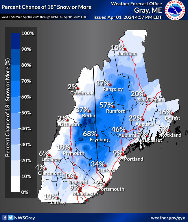
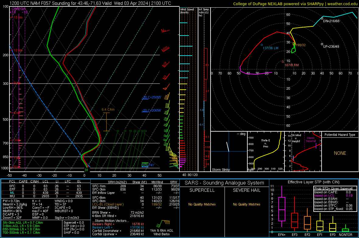
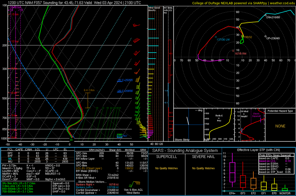
Significant Miller B Nor'easter watch, Apr 3rd-4th
in New England
Posted
@tunafish can make last call and then do his PWM measurement.