

dendrite
-
Posts
74,911 -
Joined
Content Type
Profiles
Blogs
Forums
American Weather
Media Demo
Store
Gallery
Everything posted by dendrite
-

March 2022 Obs/Disc: In Like a Lamb, Out Like a Butterfly
dendrite replied to 40/70 Benchmark's topic in New England
Why do you hate my fruit trees? -
March 2022 Obs/Disc: In Like a Lamb, Out Like a Butterfly
dendrite replied to 40/70 Benchmark's topic in New England
lolwut? Expect worse than 29° over the next couple weeks. -
March 2022 Obs/Disc: In Like a Lamb, Out Like a Butterfly
dendrite replied to 40/70 Benchmark's topic in New England
Say hello to my little friend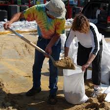
-
March 2022 Obs/Disc: In Like a Lamb, Out Like a Butterfly
dendrite replied to 40/70 Benchmark's topic in New England
It hasn’t ended. lol sucks to get a soaker when the yard is finally starting to dry out. We’ll be right back to the mud in a couple days. -
March 2022 Obs/Disc: In Like a Lamb, Out Like a Butterfly
dendrite replied to 40/70 Benchmark's topic in New England
Looks like my norovirus symptoms since 4am today. Get through the next few weeks and let’s flip the script to when we can actually pull a string of 70s. -
March 2022 Obs/Disc: In Like a Lamb, Out Like a Butterfly
dendrite replied to 40/70 Benchmark's topic in New England

-
March 2022 Obs/Disc: In Like a Lamb, Out Like a Butterfly
dendrite replied to 40/70 Benchmark's topic in New England
Probably 98. 08 was bad here but I had a lot of sleet and some snow. I’m sure there was even more frozen up your way. Maybe you held the CAD much better in 98 than torchville HIE. -
March 2022 Obs/Disc: In Like a Lamb, Out Like a Butterfly
dendrite replied to 40/70 Benchmark's topic in New England
I drove through Franc Notch during the middle of it and it was mostly wet on the trees from there through Littleton. I assume his area warmed enough to minimize icing as well. Plymouth to the mtns was a mess. -
March 2022 Obs/Disc: In Like a Lamb, Out Like a Butterfly
dendrite replied to 40/70 Benchmark's topic in New England
Looks like a big shift in temps at DXR beginning last Mar/Apr.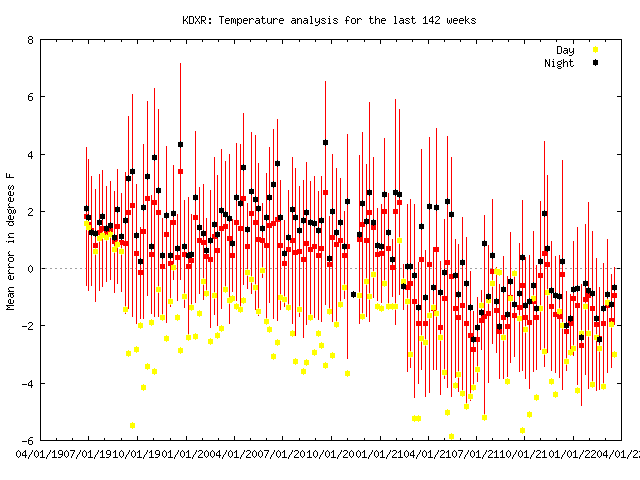
-
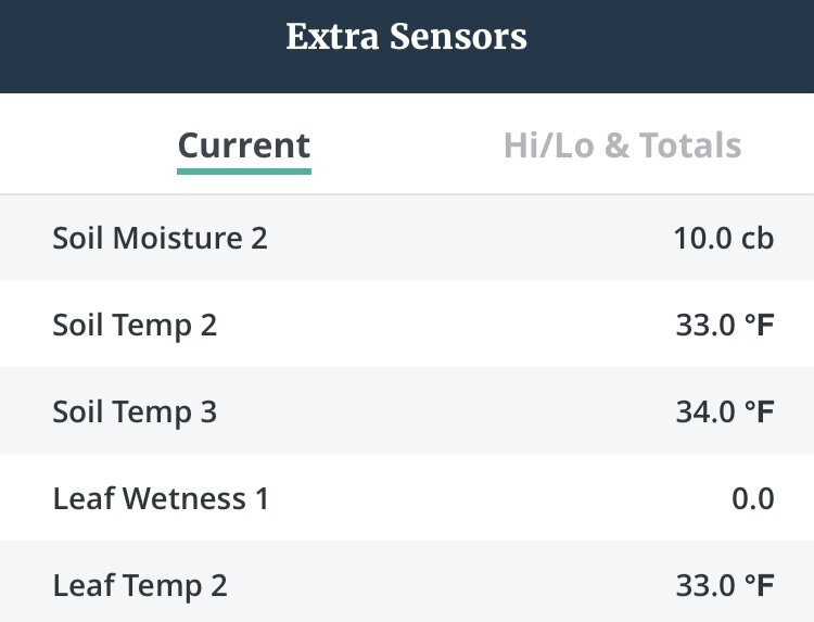
My 4” and 8”’ sensors were flatlined at 32° until yesterday.
-
Star Trek?
-
March 2022 Obs/Disc: In Like a Lamb, Out Like a Butterfly
dendrite replied to 40/70 Benchmark's topic in New England
-
Those spikes are relatively slow release anyway, right?
-
March 2022 Obs/Disc: In Like a Lamb, Out Like a Butterfly
dendrite replied to 40/70 Benchmark's topic in New England

-
March 2022 Obs/Disc: In Like a Lamb, Out Like a Butterfly
dendrite replied to 40/70 Benchmark's topic in New England
This was this evening before I let the birds out to free range. I dread walking through this every time.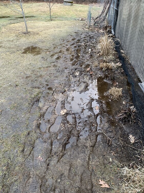
-
March 2022 Obs/Disc: In Like a Lamb, Out Like a Butterfly
dendrite replied to 40/70 Benchmark's topic in New England
I’m in a somewhat flat portion, about 3 properties long, halfway up my hill. So all of the runoff from up the hill and thawed groundwater just pools up here. I’m on the north side of the hill as well so the surface is more parallel to the sun angle than a southerly facing slope. My ground is still frozen in spots despite full sun until about 4pm. It’s just tough dealing with the water here when the ground is frozen and the plants are asleep. -
March 2022 Obs/Disc: In Like a Lamb, Out Like a Butterfly
dendrite replied to 40/70 Benchmark's topic in New England
Unfortunately this was my backyard yesterday. Today isn’t a lot better. This is why we cheer for Stein during mud season.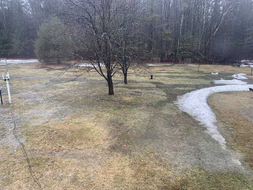
-
March 2022 Obs/Disc: In Like a Lamb, Out Like a Butterfly
dendrite replied to 40/70 Benchmark's topic in New England
We can fart 60° with west flow and 850s near 0C. Yeah, maybe over a week before the chance again, but 50° and sun isn’t horrible. Thursday looks wretched though. -
March 2022 Obs/Disc: In Like a Lamb, Out Like a Butterfly
dendrite replied to 40/70 Benchmark's topic in New England
Washout -
March 2022 Obs/Disc: In Like a Lamb, Out Like a Butterfly
dendrite replied to 40/70 Benchmark's topic in New England
On yeah…I knew that. Forgot. -
March 2022 Obs/Disc: In Like a Lamb, Out Like a Butterfly
dendrite replied to 40/70 Benchmark's topic in New England
lol -
March 2022 Obs/Disc: In Like a Lamb, Out Like a Butterfly
dendrite replied to 40/70 Benchmark's topic in New England

-
Saturday, March 19, 2022 Elevated Convection w/Severe Potential
dendrite replied to weatherwiz's topic in New England
Another deluge. Mo Nature targeting the chooks. Lots of flooding in the yard.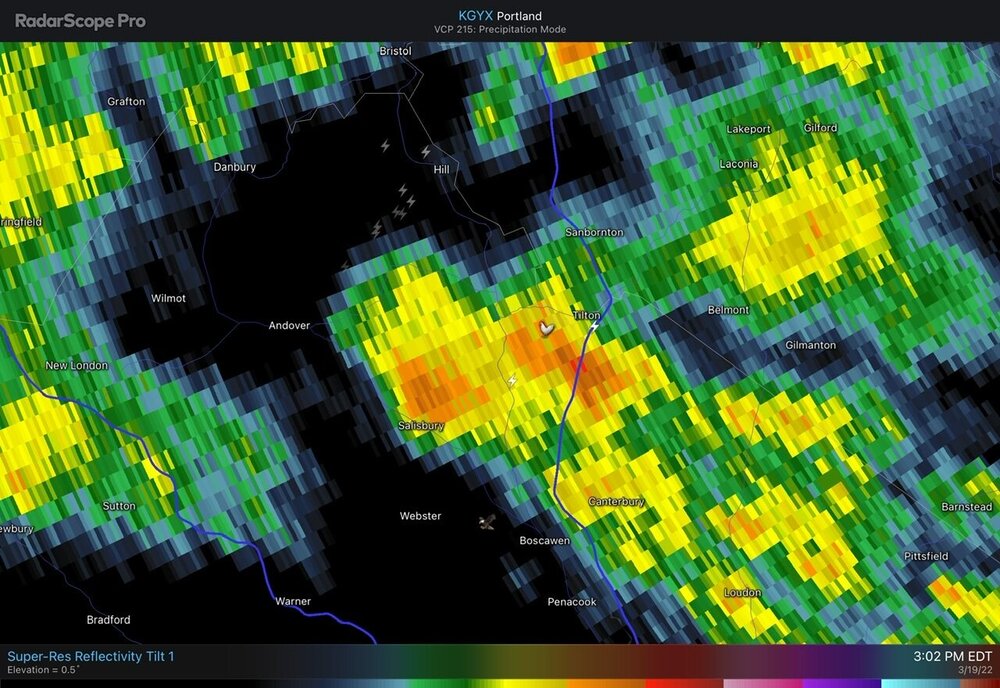
-
Saturday, March 19, 2022 Elevated Convection w/Severe Potential
dendrite replied to weatherwiz's topic in New England
Just had a really close CG. -
Saturday, March 19, 2022 Elevated Convection w/Severe Potential
dendrite replied to weatherwiz's topic in New England
More TS. Really deep, rolling rumbles below the inversion.


