dendrite
-
Posts
72,833 -
Joined
Content Type
Profiles
Blogs
Forums
American Weather
Media Demo
Store
Gallery
Everything posted by dendrite
-

It was a Flop... February 2024 Disco. Thread
dendrite replied to Prismshine Productions's topic in New England
Kidding aside…if you want an exotic system an exotic upper level pattern like that helps. -
I’m around 34”. I’ll pretty much be there after Monday.
-
Until now DCA had no 80s in the record period between 11/18 and 2/21.
-
Yup…IAD 78/79 too. So all time monthly records everywhere now.
-
Jfc wxbell has the icon hourly? lol
-
Probably wouldn’t be a record even for the date if they had a longer record history, but it’s impressive nonetheless.
-
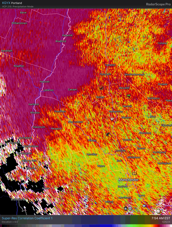
33° -RADZ 0.4” final snow/sleet. It’s a raw mess out there.
-
32.3° Mixing snow in again…50/50 snow/sleet
-
It was a Flop... February 2024 Disco. Thread
dendrite replied to Prismshine Productions's topic in New England
I was about to make the same point, but I agree. A lot of us post from mobile now too and are juggling 10 things at once. Get the post out fast and first rather than sit down at the PC and type out a longer, quality response. But we’re in the tl;dr generation now and I’m often as guilty as everyone else. But the continuous whining posts are the worst. We don’t live in Valdez. The 90s had some great years, but we had a lot of winter rain that decade too. Feb 2015s are unicorns. -
Back to raging sleet. There’s some pockets of better lift in there cooling that marginal layer just enough in spots. These small areas of higher cc are mixing with snow. Maybe another area by Mark now?

-
32° and mostly snow now…still some sleet in there
-
Out getting the chickens setup and we’re starting to ping.
-
32.0° Pouring but droppin.
-
It was a Flop... February 2024 Disco. Thread
dendrite replied to Prismshine Productions's topic in New England
The E MA melts would be interesting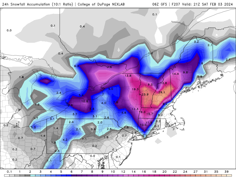
-
32.7° RA
-
Most of that is tomorrow
-
35.7° -DZ
-
Just saw the awful news Paul. I offer you my deepest condolences.
-
HRRR is a sleet fest here
-
It was a Flop... February 2024 Disco. Thread
dendrite replied to Prismshine Productions's topic in New England
Yeah 570dm over Hudson Bay at the beginning of Feb is kinda wild…especially with the euro dropping a piece of the PV over our heads and rotting it there for days. -
Throws SE NY and W MA a weenie fronto band. Maybe someone can get lucky with that.
-
ECMWF made the data free once they realized they f’d the model up
-
Even up to 42° with sun here. Love it.
-
Elevation enhancement on the qpf and sfc cold…it usually overdoes the high terrain QPF a bit. But it could be nasty down there 1k-2kft…especially with a drier CAA feed.