dendrite
-
Posts
73,516 -
Joined
Content Type
Profiles
Blogs
Forums
American Weather
Media Demo
Store
Gallery
Everything posted by dendrite
-

"Don’t do it" 2026 Blizzard obs, updates and pictures.
dendrite replied to Ginx snewx's topic in New England
There will be a lot of bad total snow and water equiv measurements with this. -
"Don’t do it" 2026 Blizzard obs, updates and pictures.
dendrite replied to Ginx snewx's topic in New England
It might be May 10 with my luck -
"Don’t do it" 2026 Blizzard obs, updates and pictures.
dendrite replied to Ginx snewx's topic in New England
Tough to snow in dry air like this.
-
"Don’t do it" 2026 Blizzard obs, updates and pictures.
dendrite replied to Ginx snewx's topic in New England
Might be toast there…lots of dry low level air. I had some bands move through and it was just light, emaciated flakes. 24/13 59% RH right now. At least there’s nothing really to clean up. -
"Don’t do it" 2026 Blizzard obs, updates and pictures.
dendrite replied to Ginx snewx's topic in New England
Really bad luck there, but at least you pounded for the first half.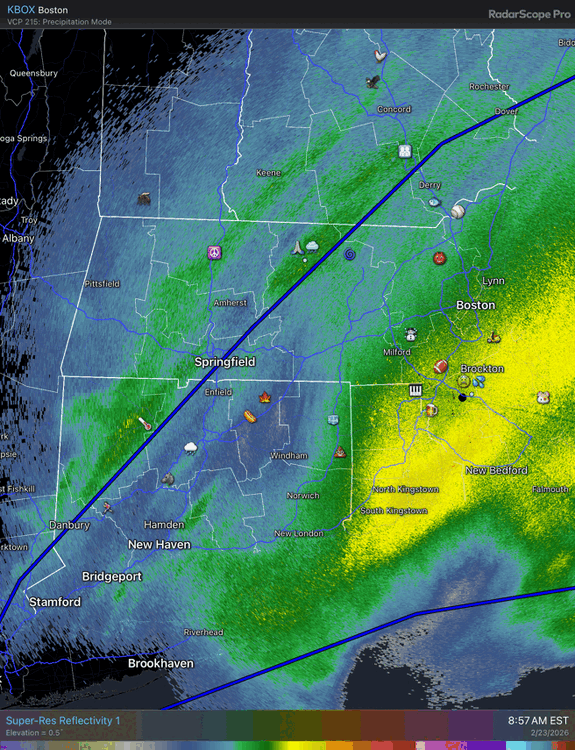
-
"Don’t do it" 2026 Blizzard obs, updates and pictures.
dendrite replied to Ginx snewx's topic in New England
3k had one more fronto push into NE MA. The toys in Methuen are on the line.
-
"Don’t do it" 2026 Blizzard obs, updates and pictures.
dendrite replied to Ginx snewx's topic in New England
Finally a steadier -SN. Let’s see if we can pull an inch. 24.1° -
"Don’t do it" 2026 Blizzard obs, updates and pictures.
dendrite replied to Ginx snewx's topic in New England
MHT was on the edge of the wind core…that late tickle SE took S NH out of the bigger gusts. Can’t win’em all. -
Sap isn’t flowing yet?
-
"Don’t do it" 2026 Blizzard obs, updates and pictures.
dendrite replied to Ginx snewx's topic in New England
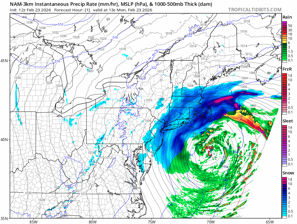
Here’s how the 3k nam plays it out the rest of the day
-
"Don’t do it" 2026 Blizzard obs, updates and pictures.
dendrite replied to Ginx snewx's topic in New England
0.5” here It may start picking up there in the next 30-60 mins -
"Don’t do it" 2026 Blizzard obs, updates and pictures.
dendrite replied to Ginx snewx's topic in New England
Dennis home station gusting to 82mph -
"Don’t do it" 2026 Blizzard obs, updates and pictures.
dendrite replied to Ginx snewx's topic in New England
Man Wellfleet 67G98 again. Let’s get a 100+ -
"Don’t do it" 2026 Blizzard obs, updates and pictures.
dendrite replied to Ginx snewx's topic in New England
That deformation band may try to get up here briefly. But with the N flow you’re going to need it to get a little north of you on radar and that may be a tough task. -
"Don’t do it" 2026 Blizzard obs, updates and pictures.
dendrite replied to Ginx snewx's topic in New England
That’s easy blizz criteria via the gusts. ASOS/AWOS always reports FG/FZFG when the vis is 1/2sm or less. But the precip indentification sensor is definitely caked up with snow hence why ptype obs disappeared. But the vis tells you what the intensity is. -
"Don’t do it" 2026 Blizzard obs, updates and pictures.
dendrite replied to Ginx snewx's topic in New England
Does his voice crack like the Brady Bunch kid when he screams at the models? -
"Don’t do it" 2026 Blizzard obs, updates and pictures.
dendrite replied to Ginx snewx's topic in New England
Seems precarious to me. Looks like it tries to throw it back a couple hours once the E MA forcing wanes. I’d probably hope the NW CT band pivots and comes east with time. -
"Don’t do it" 2026 Blizzard obs, updates and pictures.
dendrite replied to Ginx snewx's topic in New England
The mesonalysis fronto posted earlier showed it well, but there are your two main areas of forcing now. E MA is almost like a firehose right now. Then there’s the deformation further west. I think that will rot a bit and slowly move east.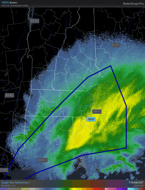
-
"Don’t do it" 2026 Blizzard obs, updates and pictures.
dendrite replied to Ginx snewx's topic in New England
Consecutive…although they have been a bit more lax on the definition in the last decade. Like allowing for 1/4sm rather than M1/4sm and being more liberal on the “frequent gusts”. Although I don’t think a random 1/2sm ob in the middle of it should negate it. -
"Don’t do it" 2026 Blizzard obs, updates and pictures.
dendrite replied to Ginx snewx's topic in New England
Dennis 58G74mph -
"Don’t do it" 2026 Blizzard obs, updates and pictures.
dendrite replied to Ginx snewx's topic in New England
Looks like BOS needs another hour of 1/4sm to verify blizz criteria. ASOS vis has been a little lacking with this. Not sure what’s up with that. -
"Don’t do it" 2026 Blizzard obs, updates and pictures.
dendrite replied to Ginx snewx's topic in New England
Wish he’d come back. It’s maple syrup season. -
"Don’t do it" 2026 Blizzard obs, updates and pictures.
dendrite replied to Ginx snewx's topic in New England
There’s some “green” bands making it around MetHerb. You can’t be getting anything like they are further east, but that’s probably your trajectory right now…from the NNE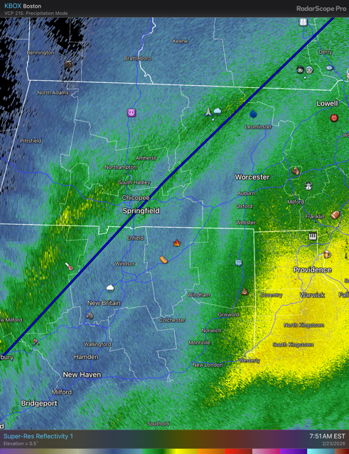
-
"Don’t do it" 2026 Blizzard obs, updates and pictures.
dendrite replied to Ginx snewx's topic in New England
Coating here…just spitting some flakes. -
"Don’t do it" 2026 Blizzard obs, updates and pictures.
dendrite replied to Ginx snewx's topic in New England
lol how?