

pasnownut
-
Posts
9,002 -
Joined
-
Last visited
Content Type
Profiles
Blogs
Forums
American Weather
Media Demo
Store
Gallery
Posts posted by pasnownut
-
-
12 minutes ago, Jns2183 said:
If KMDT gets like 2.5" I believe they will be one of the only sites in the NE or Mid Atl above normal for year
Sent from my SM-G970U using Tapatalk
yeah it appears that we are the lucky ones in the mid/north atlantic (outside of normal locals that usually cash in on temp/elevation sensitive events)
Once again, I really feel for the winter related business/industries that rely on snow/cold. My snowmobile pals are in northern maine and while they have enough snow, its notably less than normal/expected.
-
32 minutes ago, DDweatherman said:
It really didn’t, there were some models that were south all along, UK and CMC
if you go back and toggle through, you'll see that CMC was south and corrected north as event neared.
-
Just now, canderson said:
I guess that's true, I thought of tomorrow being a clipper but you're right it's much more of a boundary. Thanks for correcting that for me.
all good pal. Just clarifying cause tonights "event' is a clipper.
-
 1
1
-
-
Just now, GrandmasterB said:
GFS is…not great
it lead the southern charge for the last event, so there's that.

-
5 minutes ago, GrandmasterB said:
No idea, but let’s go with it.
fwiw tonights clipper never was meant to be much of anything round here. Northers maybe an inch.
tomorrow night isnt really a clipper, but a energy thats riding the boundary
-
6 minutes ago, canderson said:
Doesn't the NAM struggle with clipper qpf?
many times qpf from clippers is exaggerated east of mtns, but not as bad for norther westers where elevation keeps them in the game.
-
23 minutes ago, Porsche said:
Unrelated to weather, but huge fire in Ephrata, Martins Country Market up in flames and over 60 units on scene. Fire broke through containment wall and now Martin's Furniture is fully engulfed. Sad they just did a million dollar renovation.
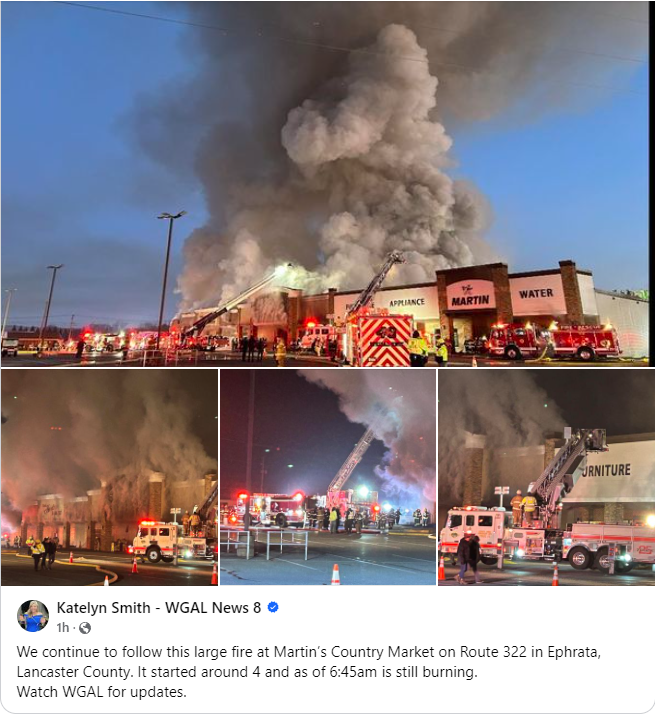
So so sad. Saw the plumes of smoke from the house, and daughter in law informed me that my fav grocery store is gone.

edit - just saw your post after i posted
-
 3
3
-
-
23 minutes ago, Mount Joy Snowman said:
Low of 20 here should help firm up the snowpack a bit. I'm thinking shaded areas can last until Friday night's snow, which by the way, I'm loving the trends on. Snow on snow baby. Let's do it.
yeah I think places like elm to manheim to etown have a shot at keeping enough to make a snow on snow deal happen. Fresh snowmobile tracks still being seen on way into work. MBY "snowpack" still 3", but many areas that are exposed are down to little. Cold temps surely helped, although Ephrata is getting lots of heat from a big country store fire (Martins - my favorite meat/grocery store). Just did a BIG remodel too. Terrible.
-
2
-
-
2 hours ago, mitchnick said:
All modeling seems to have improved for the weekend, including 6z runs. Icon remains the best, so I've attached it.
P.s. Ggem has a bomb at the end of its run. It was close at 12z, but adjusted for a home run at 0z.
I just peeked and saw that home run, and verbatim it would still have runners yet to cross the plate...
Nice to see chances continuing to pop up. Speaking of chances....wondering what the chance is for the upcoming weekend event to slip further south? GFS has been trending, but fortunately therese enough consensus that goalposts seem to be a little more narrow for this one.
-
Still approx 4” imby. Photo too large. Ugh. Sleds can still run in spots around here but lotsa melting this after. Tomorrow is colder but might not be enough to hold it unless we feeeze hard tonight. Not sure mid 20’s do a lot to help. Nice event all the same.
-
1
-
-
18 minutes ago, Mount Joy Snowman said:
Also, I wanted to mention that I thought the HRRR was an absolute stud with this storm from the time it came within range. It handled the track and evolution pretty darn well, along with the NAM. It also absolutely nailed the rain to snow changeover time, as well as the snow-ending time, and was pretty darn good with totals too. All in all, it just offered up a really good depiction of how the storm played out. Just one man's opinion.
It sure did nail it. I posted something about the mesos hitting the mark really early this morning.
Hoping they dont shat the bed w/ this next one but the shift south inside 24 with last one should give pause to what we see in the next couple days, with the exception that we are not trying to figure out what letter (A/B to affix to the next one, as its less tricky in evolution as it rides the boundary, with possible SS injection of add'l qpf if they link up a little better than currently modeled.
-
1
-
-
I'll close my nooner chat w/ nice consensus, but still most keep NS and SS separate, so for now we just have a nice mood event.
Still happy to see it and think theres enough time and space to clean up and maybe a little upside.
-
@90 its a tad south but not too divergent. Just establishes southern goalpost.
")
-
out to 78 Euro is similar to ICON/GFS/GEM in SLP placement. Glad to see it. Consensus builds for potential weekend fun.
-
something you dont often see in mid FEB.
Northern PA - brown https://www.pagrandcanyonsnowmobileclub.com/snocams/
Northern NY - Brown https://www.northernchateau.com/w/centermenu.html
Almost everyone in our forum - look outside and enjoy your snow. You are lucky
-
1 minute ago, Itstrainingtime said:
If this snow makes it until Saturday...I'll be surprised.
I'd love to see it though.
Is what it is, and if its melted by friday and freshened up by saturday, there are far worse things in life to fret over.
-
I need to get some work done, but nooners overall did not disappoint. Happy snow day gang.
Onward..........
-
4
-
-
Just now, mitchnick said:
Ggem is serving shredded wheat for the weekend. We toss.
but to the good, if one toggles through 84 w/ GFS/ICON and GEM, surface maps are plenty close enough at this range. Its all about consensus and they are plenty close for me to keep watching.
-
4 minutes ago, mitchnick said:
Come on. Guys like you and me are too good for that...

lol...I'm in good company with you (and many others here). So much fun to be trackin again.
-
2
-
-
its really just a NS vort riding the boundary and hopefully gets some help from SS. get that NS energy to slow down/dive in a tad more, and maybe just maybe we snow on snow in same week. How cool is that?
-
1
-
-
1 minute ago, mitchnick said:
Weird how the Gfs really slows down the slp from 84hrs onward. Sorta like it's waiting for something to explode. Lol
verbatim still a little too strung out for much upside (also based on flow at upper levels), but surely can be something workable/plowable.
-
1 minute ago, Mount Joy Snowman said:
GFS with a much better look and evolution this go'round. What's crazy is we're already under four days until this event. Won't be long until the Meso's are in range ha. Nothing better during the winter than having one event lead into the next.
I look forward to extrapolating NAM runs for the next 24 hrs.....

-
Just now, DDweatherman said:
Gfs is nice for the LSV folks
didnt you ask for this exact thing to happen a few hours ago? If so, keep wishing...you're on a roll.
-
at 84 SLP slightly N of ICON placement. No matter what it shows further on....thats a good step in the right direction.
Central PA Winter 23/24
in Upstate New York/Pennsylvania
Posted
herpes never looked so good....