

colonel717
-
Posts
2,910 -
Joined
Content Type
Profiles
Blogs
Forums
American Weather
Media Demo
Store
Gallery
Everything posted by colonel717
-
I think there will be additional chances especially for your area around 4/28-5/3
-
Looking at some initial signs for next winter JAMSTEC April update includes first DEC-FEB forecast.
-
Snow in May...? May see some flakes early next week. I have no desire for A/C weather. Have not turned it on yet, but may need to this week. The polar vortex split attempt (wave-2) that occurred back in early Feb will significantly impact our large-scale wx pattern in late Apr & May as the circulation & temperature anomalies from it propagate into the troposphere, leading to increased high-latitude blocking (-NAO/-AO) https://x.com/webberweather/status/2042246921671336290?
-
Looks like we could see some decent squalls if they hold together
-
I am not ready yet...I have been getting some sleet and some heavier snow squalls. I'm good with not getting fully into spring for a few more weeks.
-

Pittsburgh/Western PA WINTER ‘25/‘26
colonel717 replied to Burghblizz's topic in Upstate New York/Pennsylvania
Love these squalls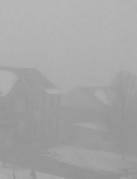
-
Pittsburgh/Western PA WINTER ‘25/‘26
colonel717 replied to Burghblizz's topic in Upstate New York/Pennsylvania
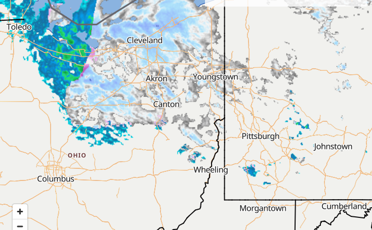
Heavy snow here, Wow. Almost whiteout.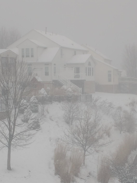
-
Pittsburgh/Western PA WINTER ‘25/‘26
colonel717 replied to Burghblizz's topic in Upstate New York/Pennsylvania
Heavy snow here now. Laying on mulch and roofs so far -
Pittsburgh/Western PA WINTER ‘25/‘26
colonel717 replied to Burghblizz's topic in Upstate New York/Pennsylvania
-
Pittsburgh/Western PA WINTER ‘25/‘26
colonel717 replied to Burghblizz's topic in Upstate New York/Pennsylvania
-
Pittsburgh/Western PA WINTER ‘25/‘26
colonel717 replied to Burghblizz's topic in Upstate New York/Pennsylvania
-
Pittsburgh/Western PA WINTER ‘25/‘26
colonel717 replied to Burghblizz's topic in Upstate New York/Pennsylvania
Hrrr like Beaver Co thru Cranberry -
Pittsburgh/Western PA WINTER ‘25/‘26
colonel717 replied to Burghblizz's topic in Upstate New York/Pennsylvania
Yeah here too. As I lay here with power out unable to sleep because my neighbors generator is obnoxiously noisy. He just got it installed last week. I can't believe how loud it is. My power just came back and his generator is still running. -
Pittsburgh/Western PA WINTER ‘25/‘26
colonel717 replied to Burghblizz's topic in Upstate New York/Pennsylvania
Live reporting on the storms https://youtu.be/FJoVzDHD9tc -
Pittsburgh/Western PA WINTER ‘25/‘26
colonel717 replied to Burghblizz's topic in Upstate New York/Pennsylvania
https://x.com/judah47/status/2029596864182452288 Judah Cohen @judah47 I can't emphasize this enough. Yes a #PolarVortex (PV) split happened but the predicted #cold for 3rd week of March in Eastern US isn't related to the classical downward influence. Instead it's our familiar friend the PV stretch, textbook looking at 100mb, NAO is raging positive! -
Pittsburgh/Western PA WINTER ‘25/‘26
colonel717 replied to Burghblizz's topic in Upstate New York/Pennsylvania
https://x.com/judah47/status/2028819681486745883 Bad habits are hard to break. As I wrote in yesterday's blog, #PolarVortex (PV) splits this week but the PV all winter really just wants to stretch! Split rapidly transitions to another robust PV stretch & with rapidly expanding cold across North America. Beware the Ides of March -
Pittsburgh/Western PA WINTER ‘25/‘26
colonel717 replied to Burghblizz's topic in Upstate New York/Pennsylvania
Both the GFS and AIEuro like 12-15th to bring winter back. -
Pittsburgh/Western PA WINTER ‘25/‘26
colonel717 replied to Burghblizz's topic in Upstate New York/Pennsylvania
Judah Cohen blog on PV stretch https://published.aer.com/aoblog/aoblog.html#PLS -
Pittsburgh/Western PA WINTER ‘25/‘26
colonel717 replied to Burghblizz's topic in Upstate New York/Pennsylvania
I don't think there would be too many who disagree with you. Go big or go home. -
Pittsburgh/Western PA WINTER ‘25/‘26
colonel717 replied to Burghblizz's topic in Upstate New York/Pennsylvania
But looks to be very rainy. I think we possibly get back into snow mode around the 12th or so as we come out of that warmth. -
Pittsburgh/Western PA WINTER ‘25/‘26
colonel717 replied to Burghblizz's topic in Upstate New York/Pennsylvania
-
Pittsburgh/Western PA WINTER ‘25/‘26
colonel717 replied to Burghblizz's topic in Upstate New York/Pennsylvania
Anyone noticing a trend... -
Pittsburgh/Western PA WINTER ‘25/‘26
colonel717 replied to Burghblizz's topic in Upstate New York/Pennsylvania
The trends are't good but still 4+ days away. -
Pittsburgh/Western PA WINTER ‘25/‘26
colonel717 replied to Burghblizz's topic in Upstate New York/Pennsylvania
GFS trending towards other guidance. -
Pittsburgh/Western PA WINTER ‘25/‘26
colonel717 replied to Burghblizz's topic in Upstate New York/Pennsylvania
Not sure why but SREFS are showing .5 in snow early evening tomorrow.
