

Terpeast
-
Posts
3,461 -
Joined
-
Last visited
Content Type
Profiles
Blogs
Forums
American Weather
Media Demo
Store
Gallery
Posts posted by Terpeast
-
-
Yes, please.
Doctor just ordered prescription glasses with special lens that block out blue light. Said it was because I stare at a white screen all day for work.
-
4 minutes ago, michsnowfreak said:
Cfs will literally change 100+ times before then.
Yes it will. But this depiction, in my opinion, is well supported by the combination of the projected nina + neg PDO + marine heat wave off Japan.
-
4 hours ago, BlizzardNole said:
Just picked a forecast (HCM City) and it's highs in the low 100s and lows mid 80s for the next several days - holy moly!
Chilly, rainy and dreary as we we wait for the warm front. What a boundary! There's a couple upper 40s in SW PA and not too far west near Pittsburgh there are low 80s. All of WV is cooking
Yep, that’s where we are. And that’s not even the hottest spot… HCM is close to the coast so it gets some marine influence that limits high temps. Areas further inland, even the suburbs, have been routinely reaching 105. Brutal.
-
Reading this forum as they look for their first 90 degree day seems a bit quaint (no offense intended) as I’m here literally melting in 100 degree heat in Vietnam. It’s been hitting 100+ for more than a month now, through the entire duration of our 3-week trip here, and looks to last through late May. Southeast Asia has been baking, making me root for a strong nina so they could at least get some relief. They need it.
-
 2
2
-
 1
1
-
-
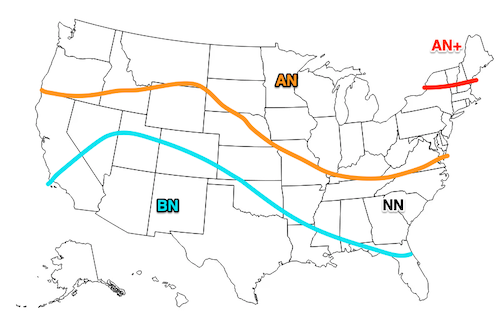
On 2/15/2024 at 1:36 AM, Terpeast said:
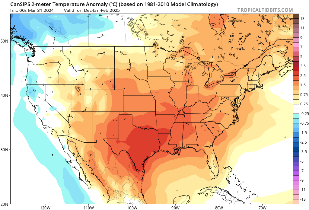
Even if this La Nina stays weak-moderate, the surrounding warmth of the oceans and the West Pac will create a very strong La Nina state much like 2022-23.
With a +QBO and solar cycle beginning to descend, we will likely have less blocking than even 2022-23. With all the cold air bottled up at the pole/Siberia or again dumping to the western NA, I'm thinking AN to much AN temps across the entire CONUS except maybe near normal over the Pac NW. East coast will likely be much AN+++ with 60s being commonplace, with strings of 70 degree days interspersed throughout even the deepest winter months.
Warmest winter on record across the east? Even higher chance of that happening than this year and last year.
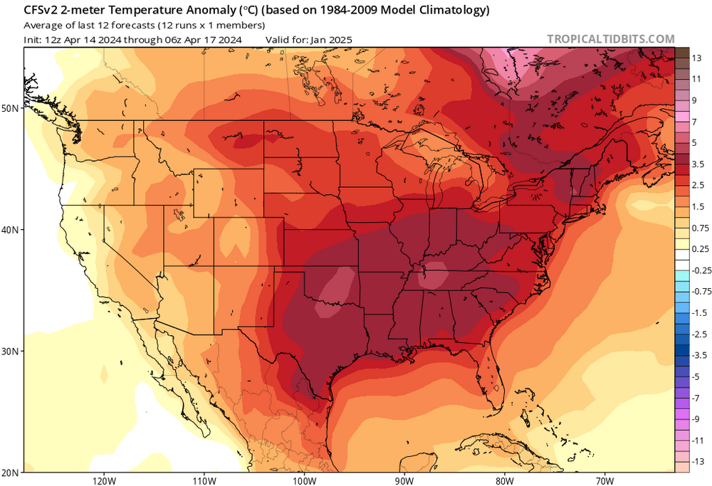
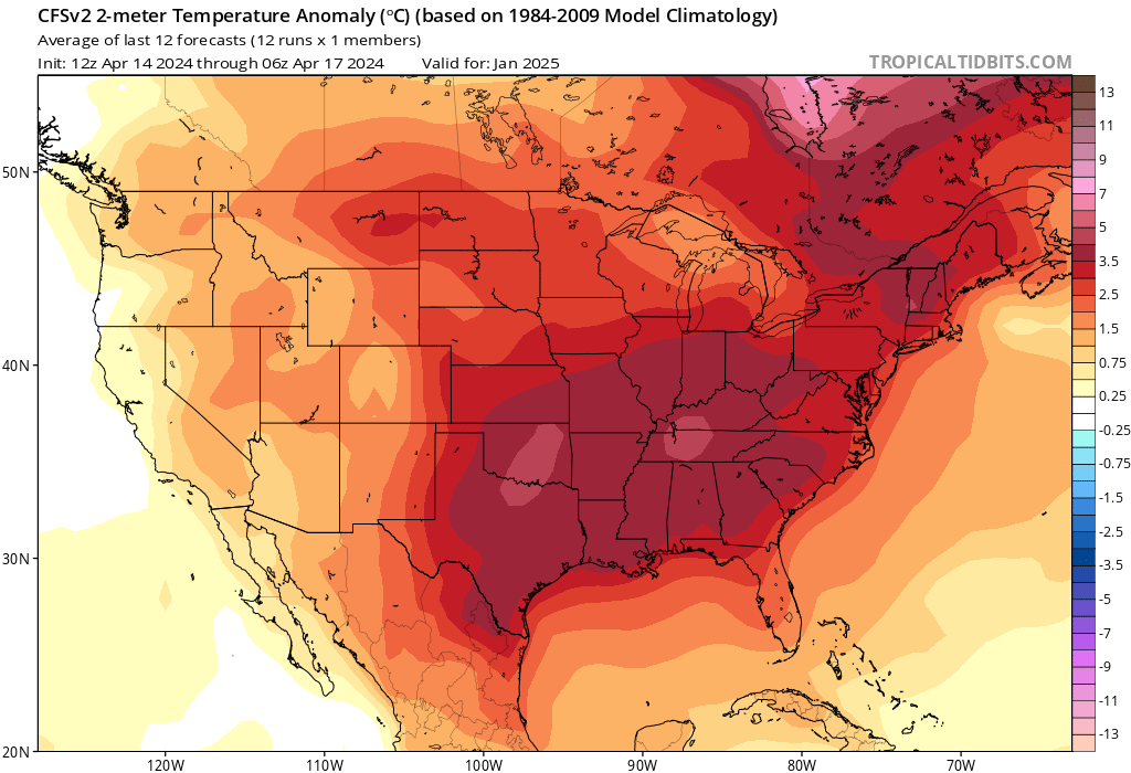
I know it’s way early, but CFS is thinking along similar lines for January.
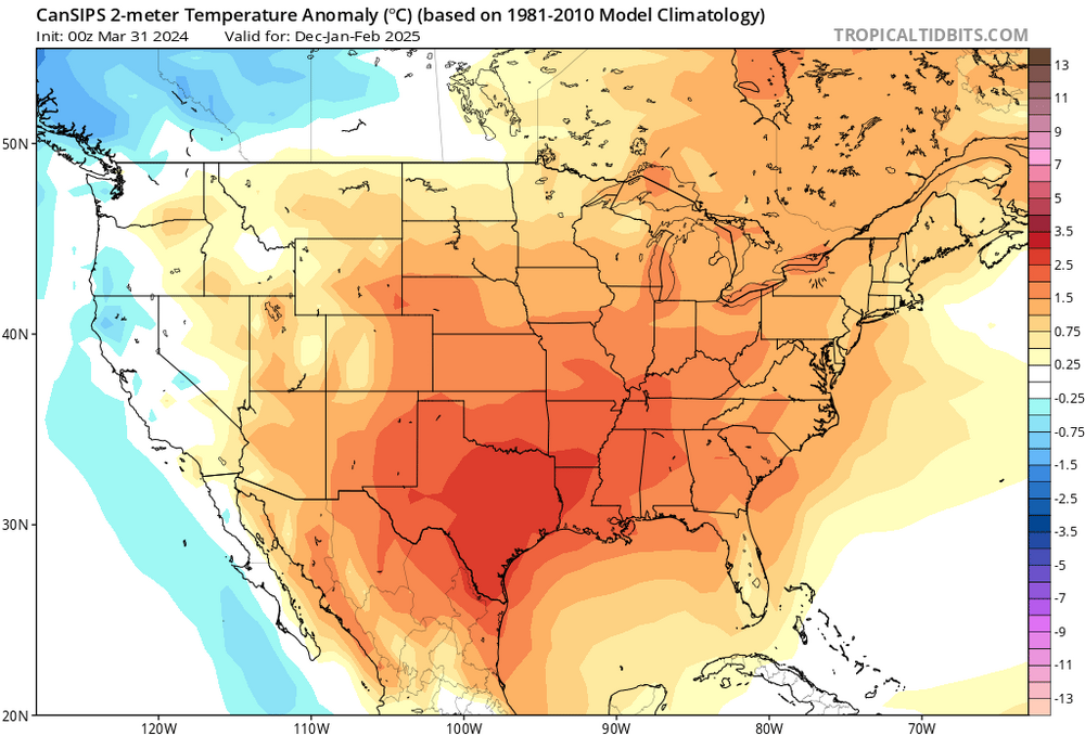
Cansips DJF
-
 2
2
-
-
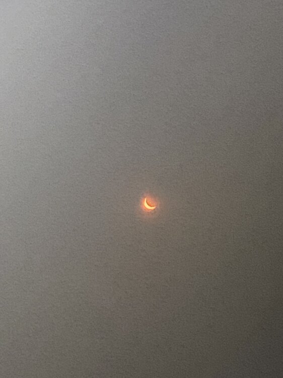
Few minutes after peak
-
9
-
-
That was cool, even though it wasn’t totality here. Amazing stuff even so. Sun was just a sliver. Felt the acute cooldown and dimdown
-
4
-
-
Getting close to 90% coverage
-
75% coverage now. Feels cooler, slightly darker. Sitting out on my deck with a beverage…
lots of big black birds are out now all of a sudden…
-
Just now, nw baltimore wx said:
We got lucky! Incredible!!! Photo is a photo from the back of my camera. Good luck all!
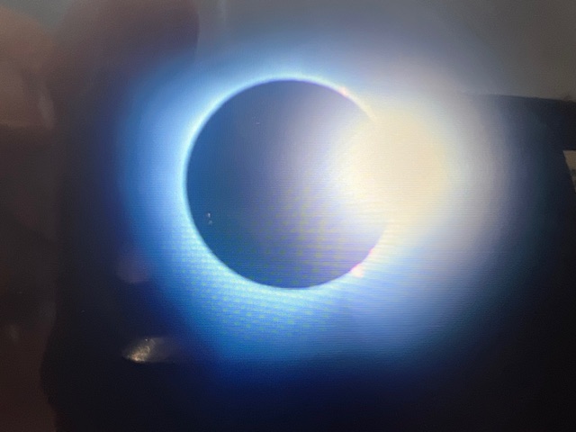
Wow, you even captured the diamond ring effect!
-
7
-
-
Yet another deck incoming, when just a few minutes ago everything looked clear. Pretty sure it’ll stay thin enough. 35% coverage
-
2 minutes ago, Paleocene said:
Scattered clouds over the immediate DC metro... go away!
Think this cloud deck went over me before you, but i could still see the sun through, so its mostly fine
now clearing up here (ashburn)
-
Skies appear to be opening up. Game on!
20% coverage now
-
1 minute ago, WxUSAF said:
lol blech. Almost overcast with 20 mins to go.
Thicker layer of clouds incoming

-
First contact made. 5% of sun clipped off
can see through the thin layer of clouds
-
1
-
-
Breaks in clouds, growing more confident that I’ll see a partial eclipse with special sunglasses at around 3-3:30 pm
-
1
-
-
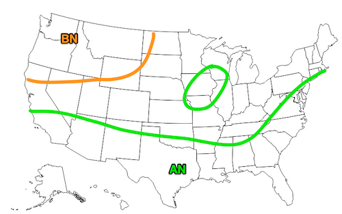
21 hours ago, GaWx said:
Latest NMME has a -PDO in Dec (no surprise). I see no reason to not remain firm at least as of now on a -PDO next winter.

Zero signs that the Japanese marine heat wave is ending. Looks like a carbon copy of 2022-23
-
4
-
-
Low of 34, but frost everywhere.
-
Just graded my 23-24 winter outlook:
-
Grading my 23-24 winter outlook vs actual results
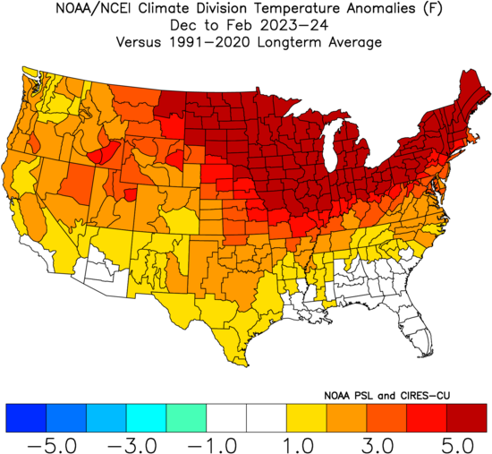
Temperatures: Decent match spatially, but off on the magnitude of the warmth. It's not just us being really warm, it's everywhere. Including Canada. Grade: B-
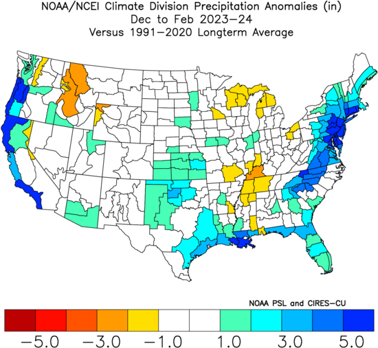
Precipitation: Good match spatially and magnitude, a little bit off on the precip maxes though both midwest and east coast. I was highly confident of a wet winter, and that did happen. Grade: A-
Snowfall: Truth is, I had at least one big storm baked into my snowfall outlook even through I cited only a 15-30% chance of a HECS. Well, that didn't happen obviously, so my snowfall guess was shot to hell. Grade: F
Overall: I think my methodology and use of MEI led to an OK outlook, but was a little overconfident on blocking. We did get blocking, but each episode was either too brief, or occurred in the wrong places. Unfortunately, the MEI is no more, and I will have to either use RONI or a different method altogether for next year's outlook. Overall grade: C
-
8
-
1
-
-
2 hours ago, dailylurker said:
Nothing went wrong. Only thing that was wrong were the humans trying to predict the future. Totally normal winter and probably better then the past few.
Yeah, I’d have to compare my conus temp/precip maps in my outlook vs actual, should be a decent match. What went wrong was my snowfall outlook had baked in at least one big storm. Which didn’t happen.
-
1
-
-
Low of 27
-
Low of 29. No frost because its so dry
-
Smoke in ashburn. Where are the fires?


May Discobs 2024
in Mid Atlantic
Posted
Stepped outside of Dulles airport coming back from relentless SE Asian heat, hoping for some refreshing cool weather… NOPE!