

tavwtby
-
Posts
2,446 -
Joined
-
Last visited
Content Type
Profiles
Blogs
Forums
American Weather
Media Demo
Store
Gallery
Posts posted by tavwtby
-
-
is this doing a loop or am I seeing things? looks a little south this run too, not that that's a bad thing
-
 1
1
-
-
Just now, HIPPYVALLEY said:
That would be fantastic because I have evening plans.
I may have spoke too soon... Nam is slower with onset this run
-
2 minutes ago, Sey-Mour Snow said:
Ya nam is like 4 hours slower the public is going to hate us even more if this thing slows down again
now looking like late evening start instead of late afternoon
-
looks like it's over early afternoon wor crowd, at least with the main thump
-
22 minutes ago, Sey-Mour Snow said:
This is a totally different system and set up but reminds me of Nov 2018 when he had 7.5” in like 3 hours then freezing drizzle from a SWFE , great positive bust and traffic was a nightmare.
remember that one well, was coming back from Boxboro from a week long test, awful commute.
-
23 minutes ago, Sey-Mour Snow said:
Keeping our initial bc of what should be a great thump for 4-6 hours .. just a few tweaks on the coast to account for the warmer trends. Not buying on too much from the trailer just yet.

I'll take! you should be good down there for a good 5/6 I think too
-
1
-
-
19 minutes ago, Sey-Mour Snow said:
Pretty cold in 18z flash freeze is crazy for mass even gets down to ct this run

sticking with my 4-8, despite what ALY and the clowns say, what say you? you do an update on the maps yet, I may have missed a few dozen pages here...
-
good foot over my head, should be nice blowing with the new ariens and newly paved driveway! enjoy!
-
3
-
-
I've got thunder snow on camera from 2013 in Waterbury that was awesome happened about five times in the span of 20 minutes during that band
-
Just now, Typhoon Tip said:
I've asked this half joking but will again ... has there ever been an NFL game delayed because of lightning in heavy snow?
not that I recall that would be an awesome thing to see though... this looks like it's going to harken back to the tuck rule game
-
still don't have a warm and fuzzy that ALY has yet to up to WSW and stayed with the watch while everyone around went up, seem to do that alot lately
-
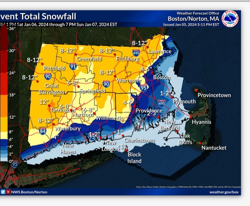
8-12 with lollies to 14 region wide?
-
looks like a good thump on the nam
-
man it's cold out there, gusty NW winds going right through ya...
-
3
-
-
17 minutes ago, 40/70 Benchmark said:
You can hear CT and RI willing the NAM to competency.
yeah, willing, but sticking with 4-8 regardless unless I see all agreement inside 24
-
1
-
-
-
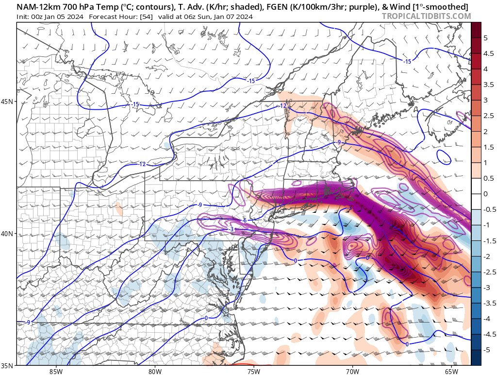
nice H7 fronto through CT on this run, looks a little more amped to me too
-
17 minutes ago, Sey-Mour Snow said:
Definitely parts of Ct and probably se New England
I don't recall any WSW last year, I could be wrong though not something I keep archives on
-
30 minutes ago, Sey-Mour Snow said:

25 mile tick NW with the goods also not as impressive with the Sunday stuff .. just noise at this point will waffle back and forth til go time..ooo... I like that one, lock it up!
-
 1
1
-
-
ALY hoisted Watch for here with 8-12" pretty much for the forecast area outside of Aly west, and SVT, but if things keep trending SE, or a later phase, we're still looking at 4-8 here for my area, unless the midlvl magic happens, have to watch the H7 vort, thinking the same as everyone else, SEMA and pts Metro West jack with this one..
-
1
-
-
nearly a half inch out there overnight, good primer for upcoming...
-
Just now, The 4 Seasons said:
First call. 3 days out, confidence is average. Probably gonna change for final on Friday but this what we're thinking ATM. Confidence is much lower around NYC/LI/NJ but thats not a concern for this forum, probably gonna have to tighten up that gradient-ha


looks about in line with current guidance and trends, would love more but will take a half footer all day these days...
-
2
-
-
looked like 4-8 imby yesterday, and leading up to that, going to stick with that for now, man it is just nice to have something relevant to track and seeing the forum pages deep from just a couple hours tells you something! enjoy the track and snow folks!
-
1
-
 1
1
-
-
I was just going to say, is this even on land and being sampled better yet? and those off hour runs always tend to loose it some, I'm waiting for the 48" nam run to spit
-
3
-


Monitoring first regional significant winter impact event. Magnitude likely tempered. At this time NE PA/SE NY and SNE primarily. Jan 7/8.
in New England
Posted
H7 fronto 0z yesterday vs 0z today...