

hazwoper
-
Posts
3,409 -
Joined
-
Last visited
Content Type
Profiles
Blogs
Forums
American Weather
Media Demo
Store
Gallery
Posts posted by hazwoper
-
-
On 2/15/2022 at 11:00 AM, Rockem_sockem_connection said:
Anyone else thinking about putting down some pre-emergent on the lawn maybe the first weekend of March? I think there's a good chance the 5 day rolling soil temp average gets to 45-50 by that time. I'd love to get a head start on it this year.
First wkend of march for pre emergent??? ahhh....no
-
 1
1
-
-
3 minutes ago, 40/70 Benchmark said:
Philly has been kind of unlucky, but I think DC is a bit above, and the Delmarva has been crushed.
Atlantic City is sitting at 32" I believe. Double the average for the season.
-
1
-
-
Just get the damn rain out before first lift on Friday at Okemo!
Signed....Philly forum member heading up Thursday night
-
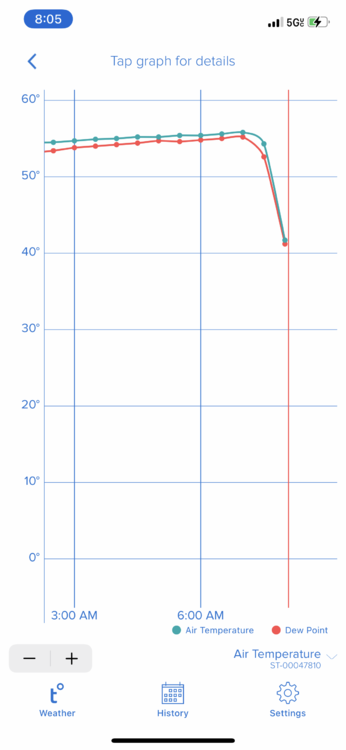
31.8 here with -SN. Looks like heavier band moving in.
-
1 minute ago, Birds~69 said:
It's nice scenery and I just took a walk which is also cool but when it doesn't stick (actually melting) it's over...
32F/light snow
Understood. Enjoy.
-
6 minutes ago, Birds~69 said:
Where's whining? I said "In all fairness every local outlet called for 1-3" which we received."
Try decaf...
You’ve been whining all morning and declaring “it’s over” even while it continues to snow and will for the next couple hours, well beyond what was forecast. The GFS Had depicted the heaviest snow in SNJ and next to nothing in SEPA.
you need a new hobby if you can’t enjoy this event. Just relax and enjoy.
-
 1
1
-
 2
2
-
-
1 hour ago, Birds~69 said:
True.
In all fairness every local outlet called for 1-3" which we received. It's the models putting us in the target zone at game time which failed is disappointing...
31F/Flakes
Dude, we met the forecast totals and really then some. I don’t get your whining posts at all.
-
1
-
1
-
-
5 minutes ago, The Iceman said:
I’ve skied this time of the year in a driving rain storm on that mountain. It isn’t ideal but as long as they have a good base up there, the skiing should still be okay. Glades will probably be closed but their main trails usually stand up pretty good in the rain. I haven’t checked their conditions in awhile recently though, not sure if they are having as rough of a winter as we are.
98% of terrain is open, so that’s good
-
hey all! Heading up to Okemo next Friday. Looking like some rain with the cutter pushing out before we head out on Friday am at this point. Not too worried about that trip as conditions should still be fine. My question is for March 11-13 up at Stowe. Bringing family there for that weekend. Based on all the signs at a warm end to Feb, how's it looking for skiing conditions at Stowe that wkend? Im staying in townhome on the Toll House lift and praying they can keep it open then. Thoughts?
-
2 hours ago, The Iceman said:
I'm hugging the NAM idgaf

where do I sign?
-
I need that warmup with rain all the way up into VT next Thursday to GTFO!! Heading to Okemo next Friday for a short weekend ski trip with my son.
-
roads were not at all good this am here in the burbs. super icing and not treated in many places.
-
28.6 with mix of SN and ZR
-
6 minutes ago, Hurricane Agnes said:
Now at the precipice - currently 33 with dp 33, and still some intermittent light rain (0.99" today so far).
wow, I'm at 33.3 an well NW of you. DP 32.7
EDIT - your elevation is why. I am at 280 you're at 400
-
1 hour ago, wdrag said:
Gotta work and expecting/hoping for a healthy grandchild #2 at Noon.
CONGRATS, Walt!
-
7
-
1
-
-
6 minutes ago, The Iceman said:
Despite the impressive drop, looking at obs, the freezing line has barely budged southeast in the last hour+ so appears the truly arctic air is getting hung up in the Appalachians.
Yeah, I don’t expect any more than perhaps a few flurries later on.
-
passage of arctic front here
-
Arctic front on my doorstep. Pushing through Doylestown now based on radar and tempest network
-
54 minutes ago, Birds~69 said:
I know you've been following weather for a long time but to think/follow any model 11 days out IMO is a waste of time if thinking fantasyland. Could it happen? Sure. But I would put odds on a limited event/bust. I could do better things w/my time. I'll grab interest if it's within 3-4 days of the storm but sure as hell not following for 10+ days.
I'm more w/Iceman thinking this month will pretty much suck. Yeah, maybe a little event or two and no super torch then we ease into March where I really lose interest. Again, good stuff could happen (and I hope) but I would bet against it and we'll just go ho-hum into Spring and then dreaded Summer.
Temps climbing/47F
The same goes with thinking a model showing warm and rain in the long term is correct. Again, it’s February and climo favors cold and snow.
-
1 hour ago, The Iceman said:
Give me some reasons to have hope Ralph.

He already did. It’s the beginning of February. All of the other stuff you posted, for the most part, is based on current modeling. Modeling, which I might add, has been dreadful.
-
2
-
-
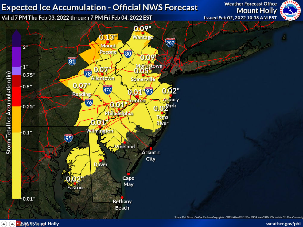
Mt Holly morning AFD:
As we go through Thursday night and Friday, the southeastward
progression of the arctic front occurs and this will be key in
the timing of the initial shallow cold air seeping eastward. A
sharp temperature gradient will exist with this front, and at
least a couple ripples of low pressure will be tracking along
it. Along and north of the wave and west of the front,
temperatures will drop rapidly supporting rain changing to
freezing/frozen precipitation. The temperature drop could also
start resulting in a rapid freeze-up across our western zones
especially during the day. The model forecast soundings indicate
the low levels quickly cool with a deep warm layer aloft
gradually cooling with time. This points to a period of freezing
rain then to sleet then to snow before ending. The guidance is
trending faster with the colder air arriving, although the GFS
still looks to be the coldest. We went ahead and sped up the
colder air arriving and therefore a quicker changeover
occurring. Some fog may occur for a time as the warmer air along
with higher dew points move over especially lingering
snowcover, although this may be limited due to the presence of a
strong low- level jet.

It looks like the guidance is coming into some better
agreement, however there remains uncertainty regarding how
quickly the low- level cold spreads southeastward during Friday.
The greatest chance for a more prolonged period of
freezing/frozen precipitation will be from the I-78 corridor
northward. As are result, some accumulating ice is expected
across these areas. Some snow/sleet accumulation is expected
although the snow amounts look to be limited. This however will
depend on how quickly the warm layer aloft erodes and how much
moisture remains before ending. We continue to think this looks
like an advisory level event for parts of our area, however
amounts will depend on the cooling of the column and amount of
precipitation falling after colder air arrives. There is an
increasing chance now that the rain changes to some freezing
rain, sleet and/or snow into the I-95 corridor and possibly to
the coast before ending.
-
Mt Holly thoughts on ice through 7PM Friday
-
1 minute ago, wthrmn654 said:
Cold air damming could also be a thing though not as common in this style storm usually that when temps are slowly rising.
It starts off warm and gets colder. CAD is not at all in play here.
-
1 minute ago, snowwors2 said:
Ralph…
Refresh me, is that yet to come or total including earlier today?
Initialized 02Z which means 9pm. So everything from 9pm forward so not earlier today.
-
1
-
The 2021-2022 Ski season thread
in New England
Posted
Okemo was brutal this past Friday. They must have groomed before temps dropped so there were large ice chunks all over the mountain that chattered the hell out of my knees and my buddy's back. Saturday was far better with snow all day. All in all, still a great trip. Now I just hope for a really good reload for my trip to Stowe 3/11-3/13