MANDA
-
Posts
3,030 -
Joined
-
Last visited
Content Type
Profiles
Blogs
Forums
American Weather
Media Demo
Store
Gallery
Everything posted by MANDA
-
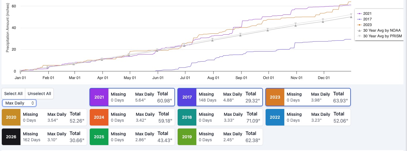
This is what I could find on the fly. Have to get out the door. Will dig further for max monthly. Note: I don't track by calendar day. Obs. are from 8am - 8am.

-
Don't have any information on rainfall rates here. My period of record here is just about 9 years. Will have to go back and look to see what my wettest month was. Good question.
-
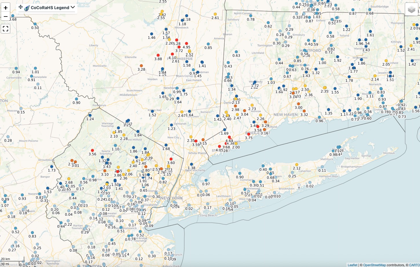
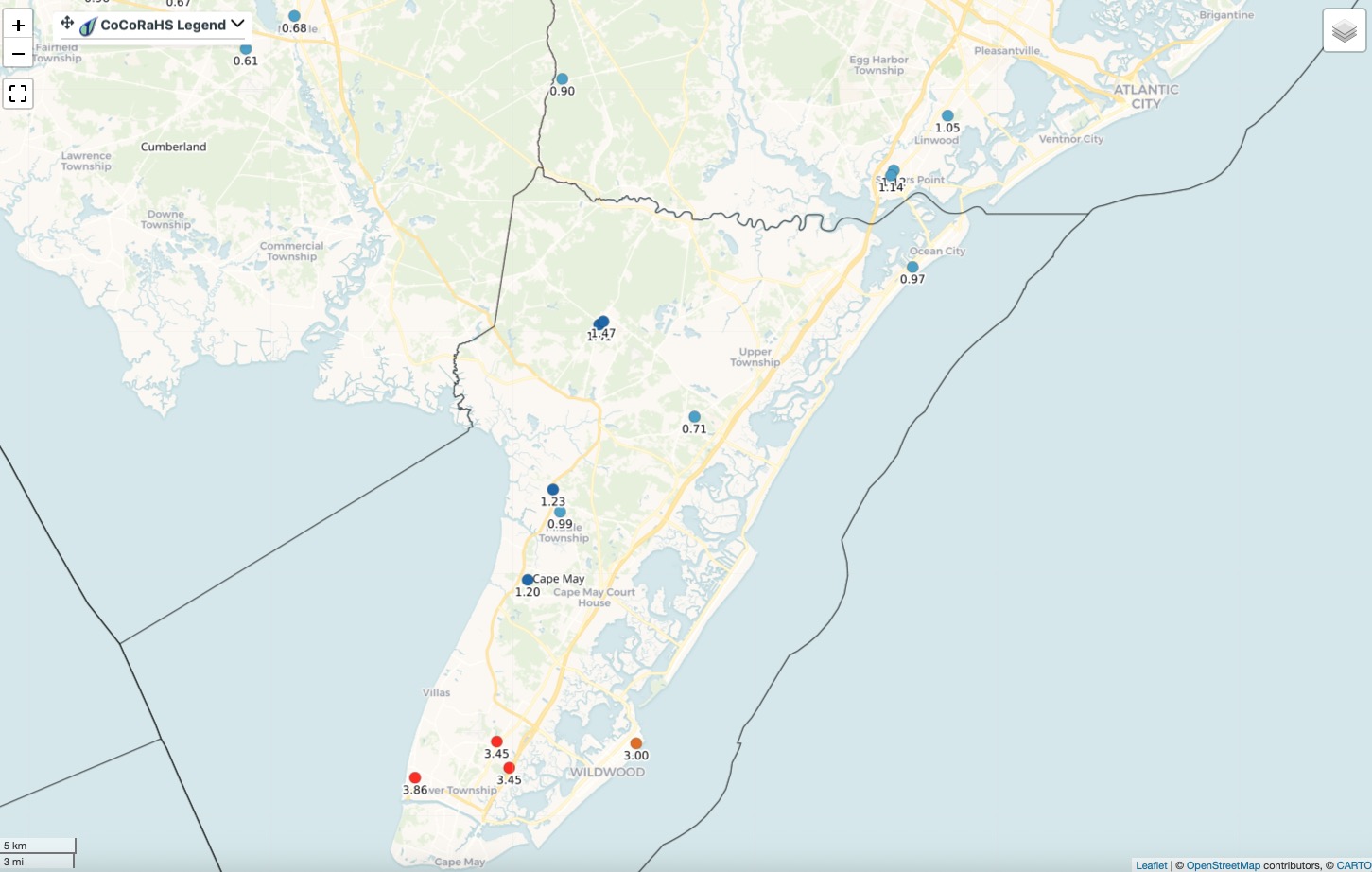
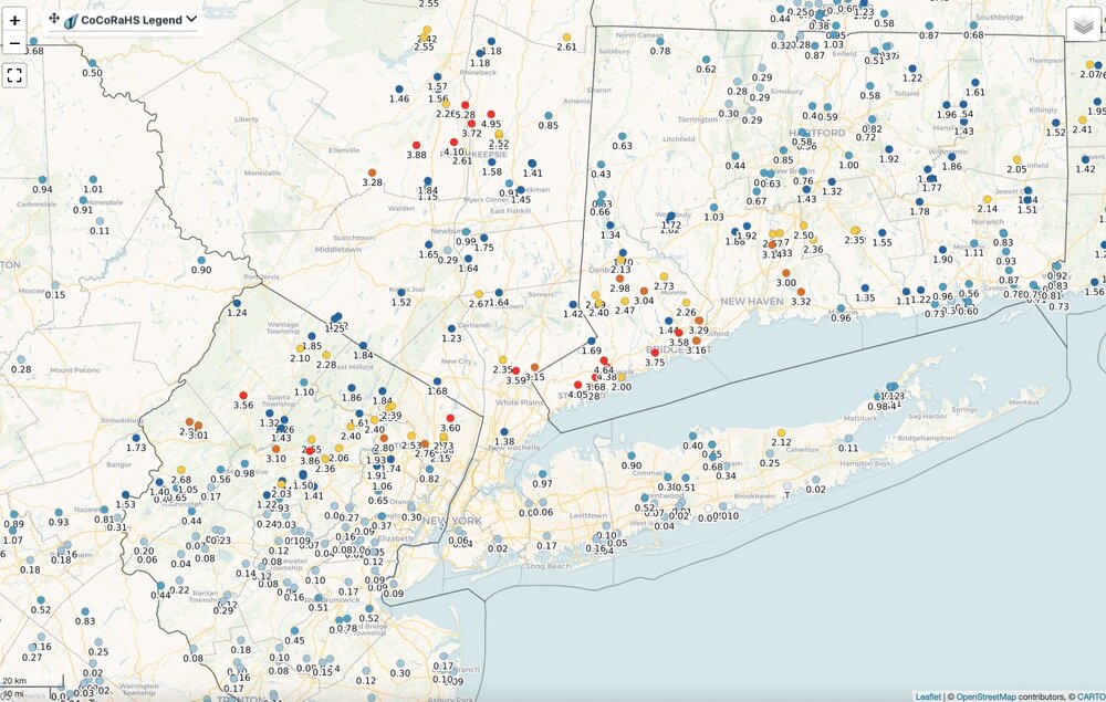
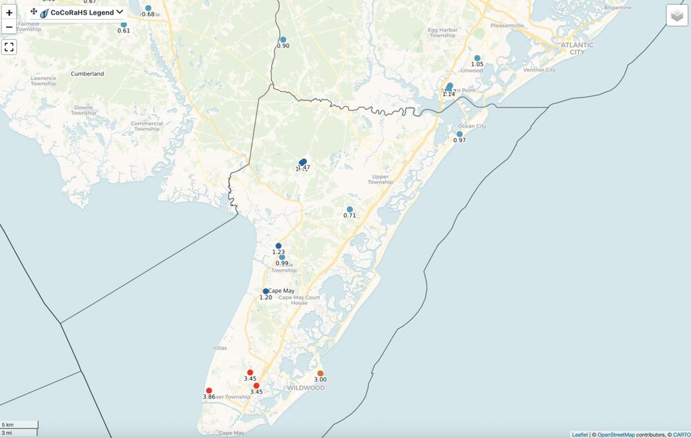
Rainfall totals yesterday. You either got in on it or you didn't. Click map to enlarge.
-
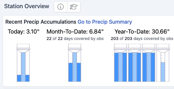
Total for yesterday 3.10". Two rounds. Early morning 1.72" in about 45 minutes. Second round with tornado warned storm early afternoon dropped 1.37" in about 15 minutes. Finished with .01" during the evening in a quick moving light shower. I'm good with rain for a while. Need some time for the ground to dry out. No need to water here anytime soon. Everything is as green as it could possibly be. @bluewave posted above the next big ridge looks to be centered more west over the western plains or Rockies. Watch for weak downstream trof over the east. Depending on placement that could signal another round of wet weather. A trof axis over the Ohio Valley or along the Appalachians would make for a wetter go around here.
-
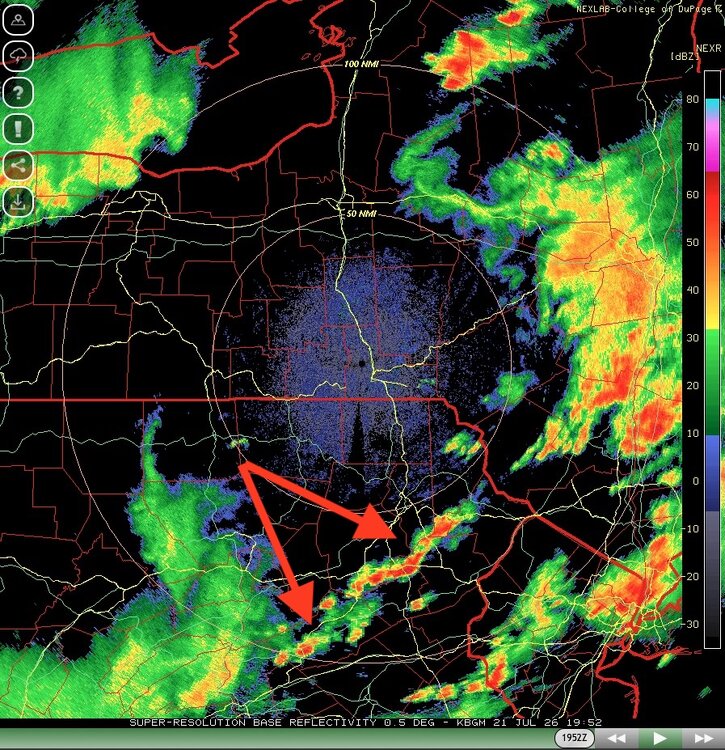
Strong storms and heavy rain crossing into Sussex County as of 5pm. Does not look severe. Heavy rains and gusty winds mostly. Threat of severe for NNJ just about over. South of 78 still in the game where airmass is more unstable.
-
Went eastward essentially right along Rt 80 / 46 corridor. Got lucky here. The hook echo was pretty well defined on radar and slid by just south of me. Rainfall total on the day 3.09". Had 1.72" in early morning round and 1.37" with the tornado warned storm. Most of that 1.37" fell in about 15 minutes.
-
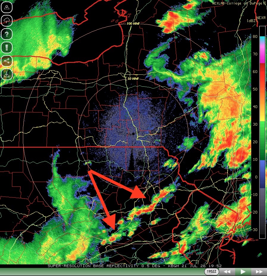
Interested to see what this line does. It has been holding in a steady state or even strengthening. I think if any additional severe for R78 northward in NJ it will come from this. If this starts to weaken as it crosses the Delaware then I think the worst is over for NNJ. CNJ on southward still in the game regardless of what this line does. Last of the NNJ current severe now exiting Bergen County. Watch the cluster south of 78 over southern Hunterdon County for something severe.
-
Great stuff. Any idea where that was filmed?
-
Not surprised. The couplet passed just south of me and was heading east along 46/80. Cams along the route were super impressive with sky conditions and wind. JCPL now reporting almost 5000 customers out. Doubled in the last hour.
-
Good luck there. Power outages per JCPL map adding up along the track eastward of this cluster of storms.
-
Traffic cams along route 80 have been impressive. Looks like night and they are bouncing around. Visibility looks like zero at times in spots.
-
This may be one of the few times dynamics rule and can produce repeated rounds of severe without much sun to destabilize the atmosphere.
-
Passed here. Rainfall was the most extreme part of it. Winds briefly gusted to 40-45 mph. Just some small branches and twigs down. If there was anything more significant damage wise I think it would have been just south of me. Impressive nonetheless.
-
Gushing rains. Winds gusting 40-45 briefly.
-
So far just modest downdraft type gusts of roughly 30 mph but with torrents of rain.
-
Legit hook on radar just south of me.
-
Same here. Phone going off. SKY IS NASTY LOOKING. Mammattus clouds. Thunder and vivid CTG lightning.
-
I have a friend in the Plainfield area and in one of the recent flooding events there it came pouring in the ground level basement window wells. Could be any number of reasons with those excessive rates. Pumps or drains with those rates are not a lock that you are safe.
-
Quite possible with those rates they could not keep up. Rainfall of 5-6" in 90 minutes is EXTREME.
-
My area as well. Taking dead aim. Thankfully they are moving quickly along so any intense rainfall rates should not last that long with these isolated pop ups. Torrential downpours still likely.
-
What an absolute joke. Yet for the 4th of July weekend events crickets! MIA.
-
Wow! Any severe flooding?
-
Received 1.72" from earlier storms. Most of that fell in about 45 minutes. It was absolute drench warfare. Looming severe threat later.
-
Robust LLC for sure but a sheared system with a "naked swirl" on vis. Shear and dry air to the north makes me think Bertha has peaked. Has about 30 or so hours before land interaction so a little window for some additional intensification but I'm thinking not. https://www.meteo.psu.edu/ewall/PSUGOES_MESO2/loop60.html
-
Same here. Absolute deluge. A few CTG streaks followed by very loud thunder. Wind gusts modest at perhaps 30 mph briefly. Will go get a measurement shortly. Easily over 1".