
dmcginvt
-
Posts
547 -
Joined
-
Last visited
Content Type
Profiles
Blogs
Forums
American Weather
Media Demo
Store
Gallery
Everything posted by dmcginvt
-
Very Avant garde picture of Sushi Yoshi
-
one of those dudes looks like pj
-
Winter storm for the 25th of February is imminent.
dmcginvt replied to Typhoon Tip's topic in New England
fret not the euro will deliver, you will get all the snow, n vermont will get 3 inch -
OBS/DISCO - The Historic James Blizzard of 2022
dmcginvt replied to TalcottWx's topic in New England
I think the video does do it justice thanks to the sound. Sound is ripping! Thanks for sharing -
OBS/DISCO - The Historic James Blizzard of 2022
dmcginvt replied to TalcottWx's topic in New England
Cheers Ginx, you earned it -
OBS/DISCO - The Historic James Blizzard of 2022
dmcginvt replied to TalcottWx's topic in New England
LOl obs thread, where are the mods Stowe VT, 0 inches, we were the cold high that made it happen. IT was cold. You are welcome. temp has actually gone up from 1F to 4F tonight -
OBS/DISCO - The Historic James Blizzard of 2022
dmcginvt replied to TalcottWx's topic in New England
And I saw the liberty bell on every school trip, and independence hall and betsy ross's house -
OBS/DISCO - The Historic James Blizzard of 2022
dmcginvt replied to TalcottWx's topic in New England
Im jacked on 52 yrs of weather -
OBS/DISCO - The Historic James Blizzard of 2022
dmcginvt replied to TalcottWx's topic in New England
You missed the frustration of a passionate man who got the shaft while nearly ever single human around him got everything they ever wanted. Being from Allentown think of the Flyers since 1975. Or the Islanders since the early 80s -
OBS/DISCO - The Historic James Blizzard of 2022
dmcginvt replied to TalcottWx's topic in New England
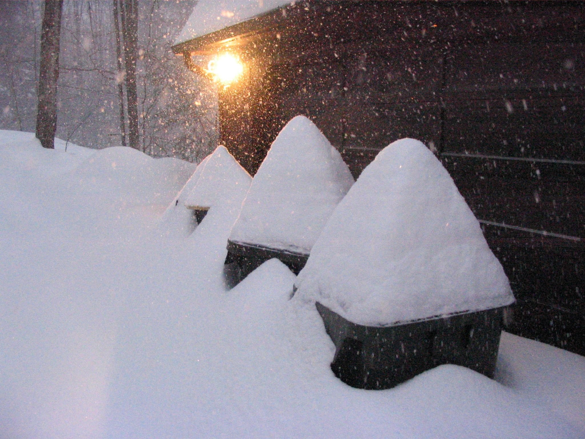
Sorry, I just realized I was simply replying to Ray and it has nothing to do with the obs of this storm...............But I'm gonna leave it because I think it's important for the future to know that VT is hurting during this winter after you guys got a big storm we didnt get :). I'm due east of Bolton Mtn on the leeward side. I lived with 2 inches of solid snow/ice and then we got about 10. It's about 8 inches of depth now. I have been here since 1987 minus the years I was in methuen and this is the worst winter ever. Total snowfall is so bad. The Mt Mansfield Stake show it https://matthewparrilla.com/mansfield-stake/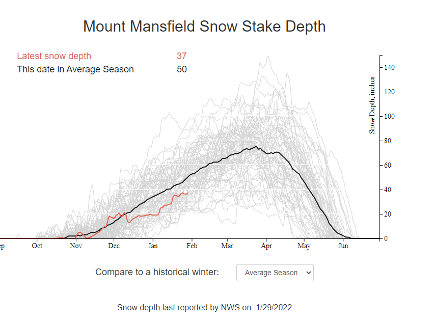
-
OBS/DISCO - The Historic James Blizzard of 2022
dmcginvt replied to TalcottWx's topic in New England
If it wasnt 3 hours away Id be going to measure too -
OBS/DISCO - The Historic James Blizzard of 2022
dmcginvt replied to TalcottWx's topic in New England
Saw this after the fact, I like super obsessive, it's called passion. And we both have it for snow. Look at Waterbury Center VT and their Snow deficit, And not jspins numbers, he lives in a magic spot with no mtns between him and the west that shadow me,
-
OBS/DISCO - The Historic James Blizzard of 2022
dmcginvt replied to TalcottWx's topic in New England
Man we bleed white, snow is our blood. It's def the reason I moved to VT from Philly. I just happened to live in Methuen from 2000-2003 and I have been following everything you say for a long time on this forum because I lived there and saw the snow they CAN get. I see how much time you p ut into following storms and you are very good at forecasting. So it actually hurts me too. My sister also live in N andover and is also a snow freak but she doesnt post. She's on the southern end mind you but she got near 20. If I was in Methuen and she got more than me, GRRRRRRRRRRRRRR. -
OBS/DISCO - The Historic James Blizzard of 2022
dmcginvt replied to TalcottWx's topic in New England
I couldnt, I may try again because Im stubborn. but I did find these quotes which completely discount my point Ray said "The reality is that if I get a foot here, I have 22.5" headed into February....that still blows. No one on here except Bob enjoys large snow fall deficits for several years running. I understand I am an easy target because I am so vocal about it, but many others here feel the same way, dude." "There are a lot of folks who would feel porked with 12" in a sea of 2' plus....you are full of shit if you think otherwise." The reality is I feel you and it's silly for me to even try to find evidence of what I think you said. -
OBS/DISCO - The Historic James Blizzard of 2022
dmcginvt replied to TalcottWx's topic in New England
Fair enough I will try to find it, I certainly didnt make it up in my head, but that doesnt mean I am not wrong, im often wrong! I just kinda recall it, so let me see what I can find. I just want to be clear I am not trying to antagonize you. I know you didnt get what you expected and I really do feel your pain and Im not trying to troll you in anyway! I mean I got zero, which I acknowledged I'd get a few nights ago, but the reality is you have more than I do and it's almost feb IN VERMONT -
OBS/DISCO - The Historic James Blizzard of 2022
dmcginvt replied to TalcottWx's topic in New England
We've all been there so many times. I recall you saying you'd be happy with 12 and you dont need to be the jackpot. But deep down I knew that wasnt true, you wanted that ****ing jackpot. Its what we all want. Story of my life. WE dont spend 10 days watching a storm for an average outcome, we want the ****ing JACK!!! Because that's the payoff, we watched it and it happened to US! Not to them!! ****ing them! They are all us but we are people and people are selfish, deep down. IT's like rooting for any team. WE expend a lot of energy in hope and not everyone gets the fruit of that hope. But when you do, it oh so ****ing sweet. We cant all have it at the same time. If we did all get it every time it wouldnt be so sweet really. Or else we'd all live near Mt Baker where it's sweet more often than not. -
OBS/DISCO - The Historic James Blizzard of 2022
dmcginvt replied to TalcottWx's topic in New England
What's even funnier is I played it on my phone initially, and didnt have sound. I went to show it to my wife and chromecasted it and then noticed the great music which worked perfect for it. You should slice that little ditty out of there and make a meme out of it ( she said I should do that, so I'm telling you you should since it's yours) -
OBS/DISCO - The Historic James Blizzard of 2022
dmcginvt replied to TalcottWx's topic in New England
Haha good stuff, that oak leaf at 1:11 looks like a gingerbread man going to do a snow angel but the snow is too much and it dies a horrible death -
Practically calm in Waterbury Center but definitely blowing in Morrisville. The windsock at KMVL looked cool as I drove by. 29 17:54 N 15 G 31
-
go outside. Scream at the atmosphere. I WANT ALL THE SNOW. At this point Im sure it's just as effective as hoping the models center on what you want to happen.
-
Leonard is still going?????? Holy shit
-
Hyde Park is a funny place and not many people know it, surely you arent in the village. You go up to garfield and it's another world especially with snowfall. And temps. Up by green river reservoir they easily get double the snow of hp village for instance. Microclimate heaven up there. ONly -13 in Waterbury Ctr so far
-
Sounds like wishcasting to me...nothing on the horizon but cold, Im going with a 2007 analog and mid feb is gonna crush it all the way to april. That's me wishcasting
-
sorry I grew up in philly and that was rare, that is all
-
My cousin came up to ski Stowe this week and he is delighted. No lines and a little refresher today. Free as a bird. They are all in their 60's and skiing a whole day, I don't know how they do it!? They did pass out 5 hours ago.


