
dmcginvt
-
Posts
547 -
Joined
-
Last visited
Content Type
Profiles
Blogs
Forums
American Weather
Media Demo
Store
Gallery
Everything posted by dmcginvt
-
https://www.gardeningchannel.com/scientists-say-dont-rake-leaves/
-
lol, PLs bring it from NC. I saw 6in at 800' on oct 4 1987. But ill never trust 372 clown. We are in ridge west trough east pattern that might last despite la nina but I think it's gonna go more zonal. That said , I dont think anything is normal anymore, GFS almost looks like superstorm of 93 Oct edition without the cold, look at how it sits there in the gulf for a while too lol and then just ejects NNE. Wouldnt be the first time we had 1 ft on the mtn with full foliage.
-
Man so much missed because of mountains. Theres no flooding. I checked everywhere. Im fine we needed this. 2.57 today, 2.96 total. Unreal at almost 3 inches. Still no flood that literally how dry its been
-
I def noticed the heavy stuff over me being just s of Stowe.
-
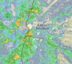
Base vs comp
-
This rain today is epic, just keeps training right over me. .5 in 20 minutes earlier, now .5 in 15 minutes and still going! 2.25"/hr rate. 1.25 so far today added to the .41 yesterday 1.66 so far.\ edit: 2.05 today 2.44 total and raining like a mother on and off still. Curious to see Jspin totals too, it's just so nice to be in the train of moisture for the first time in a long time. Looking at the radar it looks like another blast is coming!!
-
ha and then almost a half inch like that and temp down to the dewpoint. Tomorrow is going to be lovely!!
-
It's funny I dont feel like RAY when I get robbed of snow (I actually lived in Methuen and got tons from 2000-2003) because we get it it nickel and dime and not synoptically. but I do feel robbed when it's thunderstorms. I just have simply not had a great thunderstorm this year. Often the best are in Sept, here's hoping. I lived in Tx for 3 years and miss the amazing ones.
-
Sry went to a wedding in huntington, but I got 1.07 that day. So far today, man it certainly seemed to rain more than .001 but the tipper hasnt tipped but is full, only .001 so far. Totally robbed, that cell in Btown was legit looking so much lightning same with the cell to the SE. The rain will come tonight it's inevitable but jeez it's been like this all summer it seems. Also you can just check my sig it's got the link to my weather station
-
ha nevermind found the manual "The rain collector is calibrated at the factory based on the funnel diameter. The bucket tips every 0.01” of rain (referred to as resolution). The accumulated rainfall can be compared to a sight glass rain gauge with an aperture of at least 4”. Glad to confirm my own test of .01, i imagine im always possibly shy .01 and over .01 but i can live with that, long term no big dea,l but short term accuarcy is suspect
-
I have a ws-2902c, does anyone know how it works with precip? It seems to me from testing that little tipping cups holds .01 so if it doesnt tip and is full but short of tipping are my numbers .01 off? And then .01 more when it rains next? I guess for such a cheap unit it doesnt matter, Im just curious, for $179 it delights me every day. I have held off for 20 years because I always wanted a station that cost $1000 and melted precip and shit, but my dear partner bought me this and I love it.
-
I know where you are and I am probably 5 miles S by the way the crow flies. Which helps my theory that it's rained all around me, Im easily .4 less and if you got rain today even more. I love having this weatherstation!!
-
Thanks Im not going crazy, super hit or miss. Always a well worry for me. If we dont get the rain before the ground freezes, sigh, there goes my water for the winter, pretty close to 3 inches under for this month alone
-
I feel like we cant buy rain here in Waterbury Center every thing goes around us. This is what drought feels like. With every storm I watch the radar and everyone around me get rain. But it's all lies because of the radar shadows. Even btv has similar numbers to me. I show 1.37 for the month, most real reporting stations dont show much more. NWS need to come up with a better method for radar in the mountains. Yes I might be influenced by ten bends right now. NEED more Water!!!
-
I was in Stowe when it hit driving from near Golden Eagle to Shaws. Never made it past 15 mph it was raining so hard. Back to GH rd and my station only had .14in at a rate of .42/hr. That cell really blew up in 5 miles because that was some rain!! Partner confirmed it did not rain like that in Waterbury Center.
-
I tend to record them so I can skip past and find the hiking rescues. I dont know if VT fish and Game are the responders because I live near Stowe and we have Stowe Mtn Rescue and those guys are serious business. But man those guys in NH Fish and Game are amazing for all the saves on Mt Washington and Monadnock. I mean it's like some of those guys are stationed there the saves need are so often. So proud of those guys and all the volunteers who help out!
-
I get standards, but man the GOVT needs to learn to be more agile when you cannot "technically" maybe even illegaly? issue alerts for something. I knew the threat this past weekend as a minor enthusiast. My girlfriend was hiking and I said you know there's gonna be a ton of rain on the spine, its going to get into the 30's above 3000' and you need to be concerned about snow. And she immediately said that's hypothermic weather and repacked. She has her Wilderness First responder from Solo. I trust her and always give her important weahter info. When she came home she said it was not enough, she should have had more calories for the shivering she was doing, and a better opportunity for more dry things as she also had our dog as a sponge, who was wearing a pack with a microfiber towel to dry him off but the pack wasnt waterproof and the towel absorbed a ton of water that the dog carried for miles Great learning for any experienced hiker. This was very anomolous weather even for N VT.
-
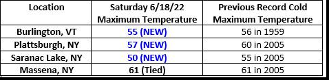
Records indeed broken, KMVL was 61 at midnight so add that in there too. Record was 62
-
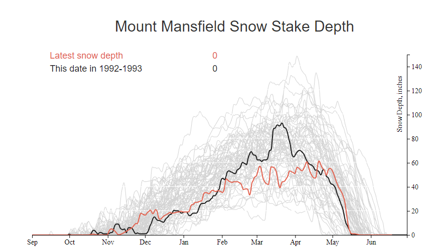
I used to have daily logs back in those years, long gone though. I do recall getting off to a weak start but it ramped up in Jan all the way to April. Includes the March 93 superstorm Chart bares that out
-
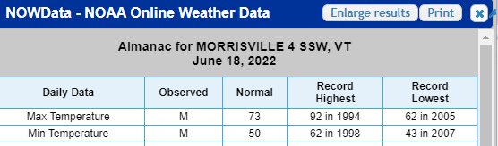
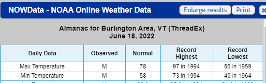
Record low for kmvl for this date is 43, Im at 47 now. Will we break record low for High temp? Im not sure Im reading this data correctly. It says record low high is 62 which I really cant wrap my head around it's seems impossibly high and surely we have been colder than that on June 18th before. Anyway we are only expected to go to 52 which is highly anomolous but record? That 62 seems so high. If it's right we are smashing it. I just looked at Island Pond it's record low min was 59. I just dont get it but it so I checked BTV and it's 56, probably better records from btv vs an asos. Sure cold air coming off the lake maybe. None of it makes sense. https://www.wunderground.com/dashboard/pws/KVTWATER64 My new weather station
-
It's beginning to look like the summer of 92 if I were to pick an analog. Many nights in the 40's. That was following the eruption of Pinatubo. I wonder if this has anything to do with Tongas explosion. The explosion was nuts but I don't think it spewed anywhere near the same amount of ash into the global atmosphere so I doubt it. Just speculation. But man just silly weather next 2 days. Btv afd mentions possible snow on the peaks.
-
Snowiest place on earth
dmcginvt replied to LongBeachSurfFreak's topic in Weather Forecasting and Discussion
https://www.mtbaker.us/the-mountain/snowfall-statistics/ It's up there for sure. -
Im almost due east of bolton, so if im still getting snow being leeward, I know the mtn is getting dumped on. Unlike jspin who being in the valley gets all the snow. I get shadowed when he doesnt, it all has to do with a girl named jenny .
-
Thanks, been snowing at 820' here on Gregg Hill for an hour now just starting to accumulate. Cant wait to tell my friends arriving that the mtn has 5" at the high rd already! Wooo go April! Edit: just let the dogs out, and they came back in covered in graupel
-
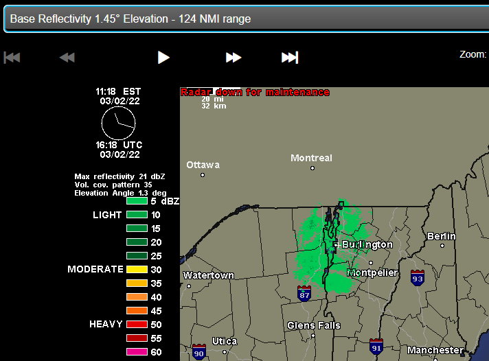
How are you getting this radar? Mine has been stuck on 3/2 for a month and I even tried a browser I never used in case it was just a cached page that wouldn't update. Nope