

psuhoffman
-
Posts
26,411 -
Joined
-
Last visited
Content Type
Profiles
Blogs
Forums
American Weather
Media Demo
Store
Gallery
Posts posted by psuhoffman
-
-
Just now, SnowenOutThere said:
I think the funniest possible outcome for this storm would be a north jump for the overnight runs before it trends back to where today's 12z has it.
No better would be it comes north then keeps going and we rain
-
 1
1
-
 2
2
-
-
We start the comeback tonight
-
7
-
-
@Terpeast obviously we’ve talked about our degrading snow climo, but there is an oddity within the trends. It’s enso neutral winters that have been killing is. Enso neutral winters used to be pretty snowy. Actually if you go back far enough there wasn’t much difference between neutral and Nino wrt snowfall. Nino snowfall actually hasn’t declined at all, but it has become more variable with bigger highs (2010) and more duds (2024). La Niña snowfall hasn’t declined much either. It was always bad and remains bad. But enso neutral winters have joined Nina’s more and more and now over the last 20 years are just as bad! Losing enso neutral winters as “snowy” is the biggest part of our snowfall loss.
Just to clarify enso neutral was never all snowy but it was half and half. Kinda a crap shoot. Lately it’s more 80/20 bad.
-
2 hours ago, Terpeast said:
El Nino next winter is not a lock. We’ll know better by summer, but looks neutral maybe nina-ish going into Fall right now
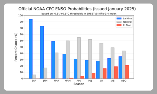
If next winter ends up enso neutral our fate is probably hanging on whether the PDO is actually flipping. +pdo neutral winters can be pretty good -pdo ones have been god awful lately!
-
3 minutes ago, LVblizzard said:
In the Philly subforum we accepted defeat yesterday, thinking okay, at least it’ll still be a decent storm for DC who hasn’t seen much in recent years. But now it looks like it’ll miss you guys too. I can’t recall another time when the models just kept trending worse and worse and worse for days at a time, to the point where there’s barely even a storm anymore. I’ve been in this hobby for nearly two decades, and while there has obviously been a fair share of storms that look great and then fizzle out, I’m not sure I’ve ever seen a snowstorm threat shit the bed in such a sudden and dramatic fashion like this.
2004 there was a storm like this that trended worse until there was no storm anywhere. Or maybe some snow in NC. I stopped following it once it got that bad.
-
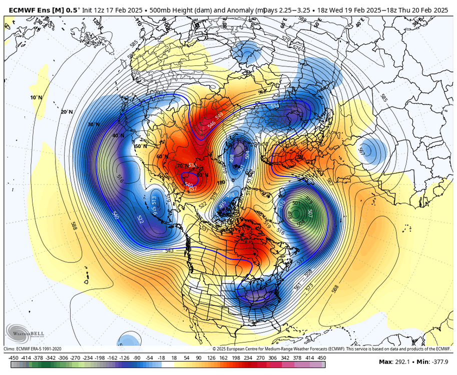
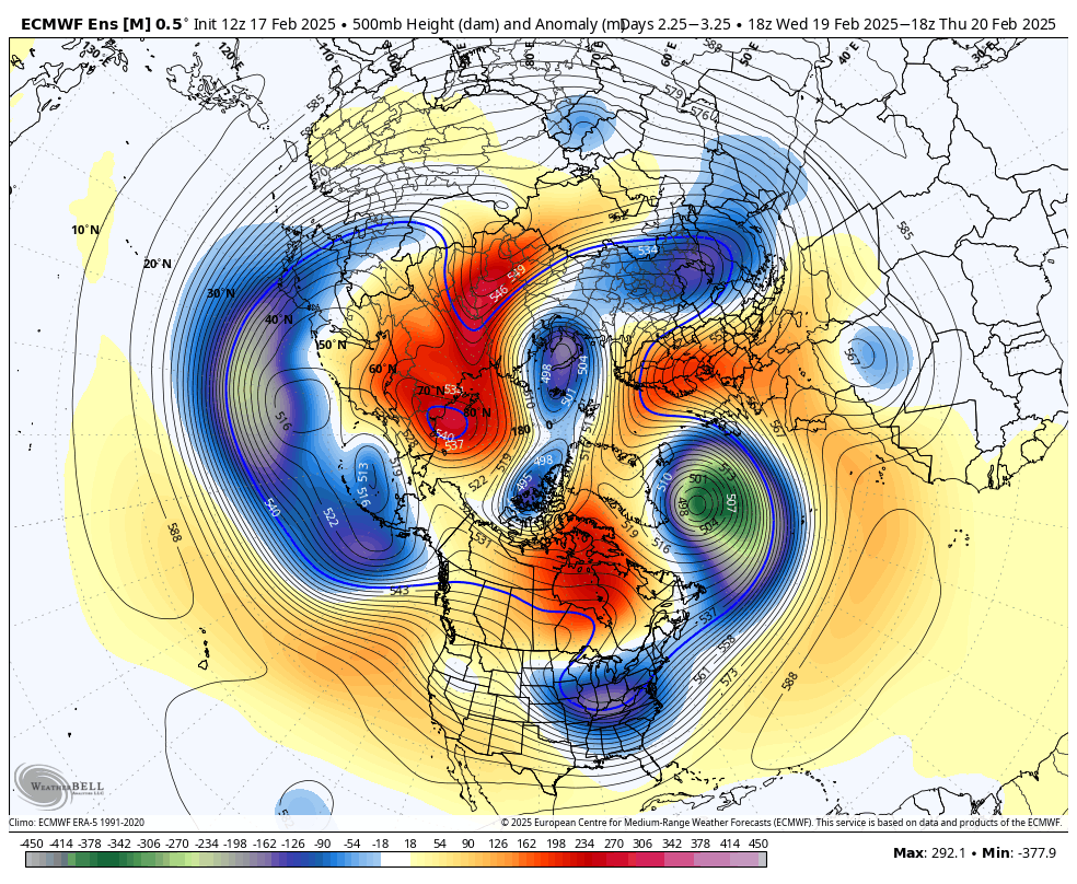
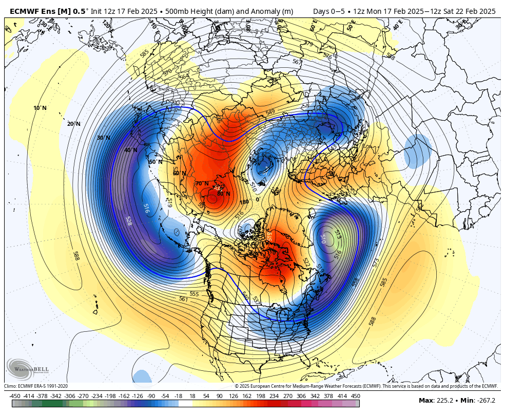
Imo it’s not one thing. It’s a bunch of tiny things. Which is why the 30,000 ft view of the pattern looks great. You have to zoom in on a lot of small details to see the flaws. Death by 1000 paper cuts
1) the kicker, I thought this might limit the setup to a MECS level not hecs level event not destroy it and I don’t think it did, runs with a storm had the kicker. But it was one of the many paper cuts.
2) the TPV didn’t detach fully. There was still a bit too much play between the main TPV and the detached lobe which kept the flow more W-E under it rather than the detached lobe acting like a true ULL pinwheel in the flow. It made the ULL act more like just an extension of the PV. This alone could have been overcome with a strong enough SS wave…
3) not a strong enough SS wave. Weak sauce that needed more of all those other minor flaws not to work against it. If we had some el Nino STJ on roids wave coming across it would have bullied through all these minor flaws and throws a ton of moisture up over this cold air. That’s why we get so many more big snows in a Nino!
4) a duel wave structure with destructive interference between the waves. The weak STJ wave starts to amplify at the exact time the NS wave over top of it was trying. We actually wanted that. Sorry I’m never rooting for some low off thr southeast coast to phase capture and bomb due north. That’s worked out like almost never. We’ve had maybe 4 MECS storms that way. Ever. That ain’t it. We want a healthy wave up into the TN valley that transfers to eastern NC or VA capes. That northern wave gets starved of moisture inflow by the wave down by New Orleans starting to amplify under it. In the end they split the energy and neither becomes the wave we need.
5) the trough takes a little too long to go negative.
6) Jim Cantore booked tickets to DC. I’m not saying he is bad luck everywhere. But not here. Never again. We should assign someone to watch every airport and tackle his ass and say “no” not on our watch.
-
1
-
4
-
-
4 hours ago, Terpeast said:
I know we’re upset about the modeling fail, and I am too… but objectively, this has been a decent winter south of i-70 especially after going in with -enso/-pdo/+qbo and a high chance of a wall-to-wall torch.
I wouldn’t change my grade on this winter even if it ended today. C+/B- imby, B+/A- for the southeast zones who jacked twice in the biggest storms. My grade is based on how much cold we had, how much snow fell, how many “snow days” we had, and how long snow cover lasted.
Model performance gets a totally separate grade, and I’m not as generous on that end.
Agree with all this. But on a side note, I (and the rest of northern MD) really needs this predominant cycle of the last 8 years where almost all our snow comes from these progressive w-e boundary waves to end. It makes sense that some of our lowlands are doing way better wrt climo than here. It takes a lot less luck in those patterns to get to climo when you avg 17” than 39” A couple lucky hits and you’re there. Up here I’m not lucking my way to a 40” that way! I need the amplified coastal to come out of retirement!
-
1
-
-
I can’t believe this is gonna produce nothing for us.

This is one of our worst wasted opportunities in a long long time. This must be how Matt Ryan felt.
-
1
-
4
-
 2
2
-
 1
1
-
-
JB threw in the towel
-
2
-
2
-
-
@WEATHER53 you have every right to feel the way you do. Really. I’m not gonna try to change your mind. You do you!
But I have the opposite perspective. As complex and chaotic as the atmosphere is with so many variables and our limited ability to sample it at every level at every location…given those realities, I’m amazed we are able to model it as well as we do! It’s so complex.
I don’t feel let down by the models this week. I feel let down by me. I started getting excited about this window before the models did. When they showed up to the party it just increased my confidence more. But it’s my own excitement and desire for a major event that let me get carried away.
I knew a month ago my analogs and pattern recognition weren’t 100%. When I listed the years I pointed out a couple didn’t really produce much snow. Most did. And when the models started showing big storms I started to dream this was one of those years. No hecs I never bought that the pattern didn’t say that but I was thinking secs-MECS. But that was risky. Even good pattern fail a lot. And I should have known better. I let my emotions get the better of me. That’s on me not the models.
-
5
-
 1
1
-
-
13 minutes ago, JenkinsJinkies said:
The posts I'm referring to were getting the point across via subtext, reading between the lines shows how they were feeling. They were also not saying it'll never snow at all again, they were saying that a 2016 style event may not happen again.
Who, who said that? Either someone said that or they didn’t and you’re just making this up. If someone said that who.
-
1 hour ago, JenkinsJinkies said:
This winter puts those extreme points to bed. Like you said, overall it is snowing less, however it’s not as bad as some of the panic posts had been suggesting these past few years.
Let’s just hope the PDO actually is flipping and we get a Niño probably in 26-27 and score then. That way it’ll shut them up for a couple years.
Who was saying it can’t snow at all anymore? Who? You say “those” Who is “those”. It’s been snowing. It snowed last year. It snowed in 2023, granted like 1” lol. We got snow in 2022. It’s been snowing every freaking year. Just less. Who is this mythical “those people” saying it can’t ever snow they you are discrediting. This sounds a lot like a scarecrow argument.
-
2
-
-
1 hour ago, IronTy said:
How do they train the AI? Do they use basically all the historical data since the modeling era? If that's the case you'd think it would be able to analogue the shit out of just about every situation.
I don’t know. I’m very curious though. It’s possible this method could do better at reducing errors due to sampling. Possible. I don’t know enough.
-
 1
1
-
-
1 hour ago, WEATHER53 said:
I expected protect the supplier pushback. What the name for that?
Starts with an “a”
But in the case of the gfs/nam/hrrr the supplier is US! They’re all funded with public dollars. There is no profit.
We aren’t defending some corporate overlords. We aren’t taking the same hostility towards these sources because we don’t share your opinion that the shortcomings of the models are some nefarious intentional design. We think the people working on them are doing the best they can and our science just isn’t as advanced as we’d like yet.
-
2
-
-
2 hours ago, Bob Chill said:
Both the nam and icon hang the tpv lobe back a little opening the door for more amplification before the TN valley. One thing that can help anyone/everyone is the shortwave to accumulate as much gulf juice as possible before approach. That + a modest adjustment in track can make up some lost ground
someone posted that JB comment yesterday “the better h5 gets the worse the surface gets” it got me thinking last night. And it brought be back to what you said about the upper low being “dead”. You were right. Getting a TPV stuck under a block and having a lobe tear off into the upper Midwest isn’t that unusual. It’s how several of our big snows came about. But it remaining totally disconnected from the flow and acting like a kicker instead of flow pinwheel and amplifying force is what is unusual. The detached lobe is acting more like the actual TPV than a typical ULL after detaching from a TPV. We wanted it further away not closer in that case!
But I do wonder if there is a tipping point at which if it does get far enough south it has to phase v act like a kicker? That might be our only hope since we can’t get a storm with a PV sitting that close to us and the ULL is acting more like a weak PV than an ULL.
This might also be why I didn’t see any in between solutions. Either snows way way south or north. This just might be a rare enough scenario though that I’m not finding any examples because the first such instance since we started keeping reliable upper level data is about to happen.
-
1
-
1
-
-
2 hours ago, JenkinsJinkies said:
Double plot turn: there was genuine concern that these patterns might have gone extinct post 2016. That talking point popped up a lot especially within the last 5 years.
I’m not going to be sucked into defending the most extreme crazy statements “on my side” or a debate. Maybe some took it way too far. I’ve not seen a lot of that. We’ve had really good discussions and by running regression studies it looks like we’ve lost about 20% of our snowfall over the last 100 years and the trend is continuing. That’s it. I’m depressed enough about that reality without listening to some nut that takes it too far and says it’s never gonna snow again.
-
2 hours ago, Amped said:
The gfs and the AI Euro did the best with this. Both took a lot of trash talk from forum members.
I’m 99% sure the gfs was simply right because of its typical errors being right in the correct direction for once. But I do wonder if the AI is less prone to errors due to estimating conditions in data sparse regions.
-
2
-
-
1 minute ago, AlexD1990 said:
I'm not trying to tell anyone how to post. I guess I'm just lashing out in frustration too because the elitism tends to rub me the wrong way. I try to overlook it a lot, but the fact that I'm about to get fringed from this damn thing too is probably making me more irksome than I would normally be. Thanks for the well thought out post, I agree with everything you said.
I only said what I said because that guys post was kinda ridiculous and hostile right off the bat. You probably could have made the point in a better way and I wouldn't have been that way.
-
1 minute ago, mappy said:
But not the snow

Sorry
-
1 minute ago, mappy said:
I wouldn’t count on a reversal and things get better for us, but hey at least the Eagles won the Super Bowl.
See now you're getting it!
-
@AlexD1990 my non Ass response... the mid atlantic forum is too freaking large geographically. Look at the other forums, NYC metro and Philly have their own... there is one just for PA but its really become central and western PA and the southern part is in ours and the eastern is in Philly.
The geographic area "mid atlantic" is too big to have a producting regional discussion about the weather. There is almost no chance, for example, a snowstorm that crushes the southeast parts of the "Mid atlantic" even gives me flurries up here on the northern edge of the mid atlantic. And frankly I am NOT even the northern edge of the actual mid atlantic as most definitions of that include PA. But I am the northern edge of this forums arbitrary geography. The point is the weather differences between Hagerstown MD and Va Beach are way too ridiculous to be in the same thread. They are screaming YES this is awesome for the same run that makes us want to dive off a cliff. And you can't pretend this is 100% science and not emotional. Frankly this thread even restricted to the DC centric area is still difficult as MOST storms wont affect us all equally...my biggest snow this year skunked most of this thread and their two biggest snows fringed me. But at least the storms affect us. Some systems that affect parts of the larger regions dont affect us at all.
So we have to have sub regional threads within this way too large geographic sub forum imo. And telling the people how to feel and post is kinda silly. That is NEVER going to work. THink about that.
-
4
-
-
2 minutes ago, AlexD1990 said:
You do understand there's a difference between form and thread, right?
yes, but do we really need to have a semantics discussion now because I misspoke?
-
8 minutes ago, Solution Man said:
We got skunked @ 6z, I will take it
the 12z isn't any better for me, I went from 0" to 0"
-
2
-
-
2 minutes ago, snowfan said:
You do that for the rest of us. We don’t need more of it.
Paragraph please
-
2
-
FOLKS Feb 19-20 Debacle
in Mid Atlantic
Posted
The analogs are going to be right but in the other way. I was looking for Richmond to Delmarva big snows. I found none of them with a similar h5. I wasn’t even considering it would go south and be a Va beach snow. When I pulled those up….there were some matches. You don’t see many in between. With a TPV there it either phases and comes up or doesn’t and gets squashed way south.