

psuhoffman
-
Posts
24,041 -
Joined
-
Last visited
Content Type
Profiles
Blogs
Forums
American Weather
Media Demo
Store
Gallery
Posts posted by psuhoffman
-
-
2 minutes ago, PrinceFrederickWx said:
The sample size for this is way too small, and even still, I can’t find one that isn’t a dud other than 95/96.
2006 wasnt bad...but if you adjust that season to the post 2016 warmer reality most of the snow from that season might end up rain.
-
@Ji remember when you kept saying "you hope that one week with 2 minor snows wasnt our "january 1987". Well 2 of my top analogs were 1966 and 1987. Both had one epic week in January and then a fluke "warm" snowstorm in February. Look at this winter...we had one cold week in January with 2 snows but they were minor then in mid Feb there was a perfect track rainstorm where I got 6" of slop. Maybe this was those winters but adjusted for today's climate. Warmer with a faster more energetic NS running interference. This is just what that produces now.
-
 1
1
-
-
41 minutes ago, Ji said:
It’s been negative every month since 2020!Yea, you're right if you just look at all ninas following nino's its not that bad...but next year has a LOT stacked against it. Severely -PDO regime, very very warm current base state, unfavorable QBO, likely past solar max so unfavorable there too... just not much to be optimistic about unfortunately. Just hope for a fluke. 2000 was a good example. That year was just awful the whole winter except 10 days...and we got 3 snows in those 10 days and remember it as a good winter.
-
1
-
-
20 minutes ago, Weather Will said:
You mean something like this, and I'm not being snarky....WB Extended control.

even that doesn't get it done, its just a perfect track rainstorm, which is my point.
-
28 minutes ago, Blizzard of 93 said:
I see your point & I know that you want it snow as much, if not more, than most of us.
We would need to get lucky & time something right during the last 2 weeks of March, but that is the case in just about every year.
The end of the Control run incoming temperatures at hour 360 could give a well timed & near perfect track storm a chance, especially for the north & west crew in both of our forums.

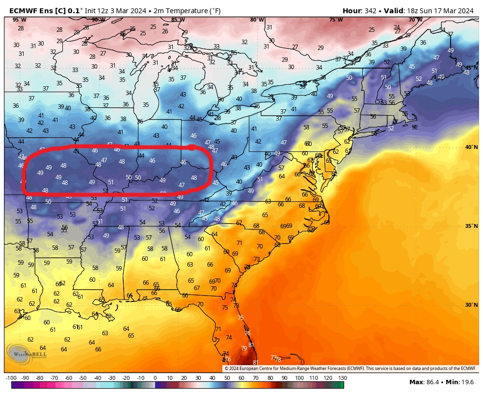
I wouldn't use the temps at 8am after a night of radiational cooling to judge the quality of the airmass. The reason I pulled the plot I did was there is actually precip going on behind the wave across much of that area during the time I circled it. Yes it's not heavy precip but it gives a clear idea of what we're working with. Even under some precip its in the upper 40's and near 50 in most places. It would take a really anomalous event to cool that airmass enough to support a snowstorm.
-
1
-
-
1 hour ago, Blizzard of 93 said:
The 12z Control then rides another low up the coast on day 15, but colder air doesn’t move in until after the storm departs.


Look at the temps under those coldest anomalies at our latitude...

this is what's incoming on that control run, and it matches the anomalies on the ensembles also...and is colder than the GEFS and GEPS frankly...
This is JUST NOT COLD ENOUGH... I wish it was. This isn't what I want. You know I get excited when I think its going to snow...I was giving this period a chance, at least some chance...until maybe 3 days ago when it got into range to start seeing what the temp anomalies realistically looked like and its just not good enough. Not shocking given its been the warmest winter ever across the continent. Actually was silly to think there was much chance suddenly real legit cold was going to show up in late March. The only chance for significant snow I can see now would be some crazy once a century type event, some phased bomb that stalls and destroys us, and even then I don't know if it would be cold enough in that airmass...it's just very unlikely.
-
 1
1
-
-
@Ji I think it fully depends on if the pdo cycle continues. But it’s unlikely to flip heading into a Nina. Unfortunately Nina’s following a Nino in a strongly -pdo cycle are not as favorable. Look at the Nina’s in the early 50s and 70s, 2017 and 2020. Yea 2020 was a neutral but in a strong Nina base state it behaved like a Nina following a Nino. Additionally you have to impose the current temp regime into Past analogs. Even if we got a 2006 repeat for instance, the 3 biggest snow events that winter were all extremely marginal wrt temps and likely would just be rain right now in this current torched pacific PDO regime!
-
12 minutes ago, Ji said:
I think people are being too lazy with regards to next year winter outlook. I bet it’s way snowier than we think . Study Nina’s after ninos
What examples are you using?
-
@Jilook at the euro control for example. It develops a low around the 18th, perfect track, but it’s in the 40s under the CCB! Only place that gets any snow is above 3000 feet and that’s iffy. That’s what those anomalies translate to in late March.
We need arctic air. Absent that it would take some truly crazy event like a stalled 970 low that goes nuts.
-
5 minutes ago, Ji said:
As long as it’s blue that far out we have a chance. A storm may pop up and those blues maybe darkerA chance sure. But that isn’t what we want it to look like to feel confident.
-
5 minutes ago, Ji said:
You mean February? Even those epic runs never showed really cold weatherYes and I said that bothered me remember. But in February slightly below normal can work. Not in late March.
-
1 minute ago, Ji said:
lol. There is the anti christ and then there is the anti weenie(you). You will destroy anyone with winter hope swiftlyI was just horribly wrong just a few weeks ago when I was full weenie mode. But that just isn’t cold enough. The last week of March we need those anomaly maps to show Barnie.
-
3 minutes ago, Weather Will said:
WB 12Z EPS....looks pretty good to me going into the Hail Mary period toward the end of March.


That isn’t even close to cold enough.
-
5
-
-
55 minutes ago, Weather Will said:
GFS has abandoned the idea of any snow this upcoming weekend. Will see if the weeklies/ GEFS extended hold for a Hail Mary chance later in March.
Shocking
-
1
-
-
8 minutes ago, snowfan said:
It’s great to hear that your new base state is bringing your daughter joy. At the end of the day, that’s all that matters.
She is 5 and lives in the moment. If it was snowing she would be equally happy
-
3
-
-
My 5 year old daughter came in excited because she found flowers growing and saw a bee.
-
4
-
-
1 hour ago, Weather Will said:
We have had only one snowy week this winter; even you were troubled at times that the long range models were not snowier in response to the great H5 looks.
I wish I had a few inches of snow for every great H5 map shown in the threads this winter....reality sucks sometimes; nothing done in these threads has any effect on the actual weather.
People should not use me as a scapegoat for the bad winter; or what unfortunately turned out to inaccurate prognostications.
Finally, I really wish the medium/ long range threads were reserved for people's thoughts on weather, if you don't like what I post don't read it! If it is an inappropriate post, mods can delete it. If you thing the weather maps I show do not accurately depict what is going to happen post your own thoughts on what will happen.
you're deflecting though... my issue wasn't that you were conservative all winter...I never said anything about that. But why now, when the odds of snow are way worse...are you suddenly posting the snowiest guidance from each run?
-
2 hours ago, Weather Will said:
I know mid to late March is getting real late but the guidance has not folded yet like it did for February. If/ when it does then I will show that. I really don't understand the personal attacks in this place.
Mine wasn’t a personal attack it was a valid question which you didn’t answer. During the winter when we do have a more realistic chance at snow you typically find the least optimistic piece of data. You never show some control run or cherry picked obscure op run that shows a big snowstorm. You typically show the ensembles and even then you usually tend to snow the least snowy presentation. If it’s snowy day 9 you will show the day 1-7 mean lol. If the mean is snowy you will show the probabilities, which granted are a better way to depict our snow chances but still my point is you always show the most conservative guidance.
Now it’s March and we’re looking at a period that’s very likely too late and now you’re cherry picking op runs and 600 hour control runs that show snow. My observation and question why is valid. And Zens conclusion you are trolling is a logical one given that evidence. If you have an alternative explanation feel free to provide it and set the record straight.
-
1
-
 1
1
-
-
53 minutes ago, cbmclean said:
Better get the knee in shape!!
It’s going well so far.
-
42 minutes ago, cbmclean said:
You grunted it?
That’s how hard it was to type all that.
-
11 minutes ago, Weather Will said:
WB latest GEFS control also has a storm after the 20th. May be too little too late but more digital snow than late February ever showed.

All winter you find the worst looking long range guidance to post. Now when there is almost no reasonable chance of snow for DC you’re cherry picking 600 hour control runs. What’s your deal?
-
2
-
2
-
-
@CAPE I was just looking at some of the data and updating my enso snowfall files. Here is the problem... La Nina's have not actually been getting any snowier...actually they are getting less snowy too, but they are getting less snowy at a much slower rate than neutral and nino's which lately have suddenly gone from being significantly better than Nina's to now sucking maybe even worse...definitely worse in the case of neutrals.
20 years ago the data strongly indicated our best enso phase by far was Nino's, followed by neutrals and without any question the worst were Ninas. For BWI at one point not too long ago the averages were ~28" in a nino, 19" in neutral, and 15" in a nina.
The sad state of where we are is that Nina's are not any snowier...but that 15" average now just looks good v bad because neutrals and ninos have suddenly decided to suck because we no longer can easily get cold enough without the NS. The problem is a lot of NS involvement while it does make us colder...or it can when the trough is in the east...it also runs interference on getting bigger juiced up storms at our latitude! So its a catch 22. The problem is we are no so freaking warm without the NS that we might be better off rooting for that and taking the nickel and dime crap we can get because everything else equals a no chance shit the blinds torch pattern.
The problem is this leaves us very little chance of a "what used to be considered" a snowy winter...one where all the airports go over 30" for example. I just don't know what would even give us a good chance of that right now given how warm it is when the NS gets out of the way, and the fact the NS being involved makes it less likely to get big storms.
-
@Terpeast revelstoke has snow data on their website for every season going back to 2008. You can make a graph that shows seasons snowfall by week. Take a look as it’s pretty indicative of the patterns for that area.
-
@Terpeast just a thought, sorry if you already know this…if you do go to the powder highway resorts Jan and early Feb are good (often Jan better than Feb) but I wouldn’t book in advance later. First of all they typically get dumped reliably early in November, December and early January when the pac jet is further north. They also aren’t high elevation and can start getting thaw freeze cycles in Feb and even in recent Nina’s it’s been warm at times out west too. Plus sometimes in Feb as the pac jet relaxes some the storm cycles can start sliding south of them.
This is in contrast to the southern very high elevation resorts in Colorado where later is often better.
-
1
-


What Went Wrong in Winter 23-24/Base State/Will It Ever Snow Again??
in Mid Atlantic
Posted
How did you determine the current temp base state? With the temps having spiked so much the last 9 years might those methods be underestimating the warmth at all. I know some if this current extreme warmth might be cyclical not permanent so I’m not saying we should have estimated it based on the last 5 years but wondering if when adjusting a winter from prior to 2016 if right now we’re in a worse spot than even that method indicates.