

psuhoffman
-
Posts
24,041 -
Joined
-
Last visited
Content Type
Profiles
Blogs
Forums
American Weather
Media Demo
Store
Gallery
Posts posted by psuhoffman
-
-
30 minutes ago, Weather Will said:
Oh and there is a storm on the WB EPS control for the late March- early April period if you are dreaming of a White Easter.

Ok if we’re being more realistic guidance does suggest there might be some pretty awesome snowstorms up in the mountains of Vermont, NH, Maine the last week of March and early April. If you need to see one more snow that bad just plan a trip. I’m stoked for what it could mean for the late ski season.
-
 3
3
-
-
6 minutes ago, Ji said:
You guys do realize we are 2 to 2.5 hours driving from areas that do better than much of New EnglandI can’t speak for Terp but I go out west primarily for the skiing. If I just wanted to see snow yes I’d just drive somewhere. I’ve done snow fix weekends to western MD and WV.
-
15 minutes ago, Ji said:
At this point we are looking for one snowstorm…not a 3 week pattern change !I’m just making an interesting observation. Make if it what you will.
-
1
-
-
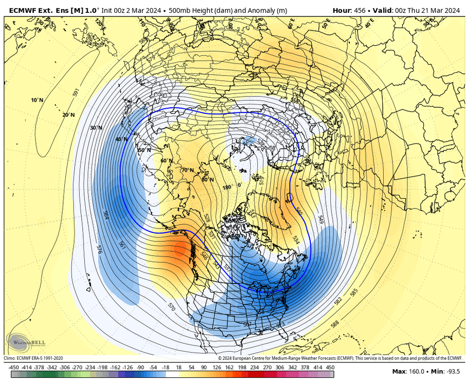
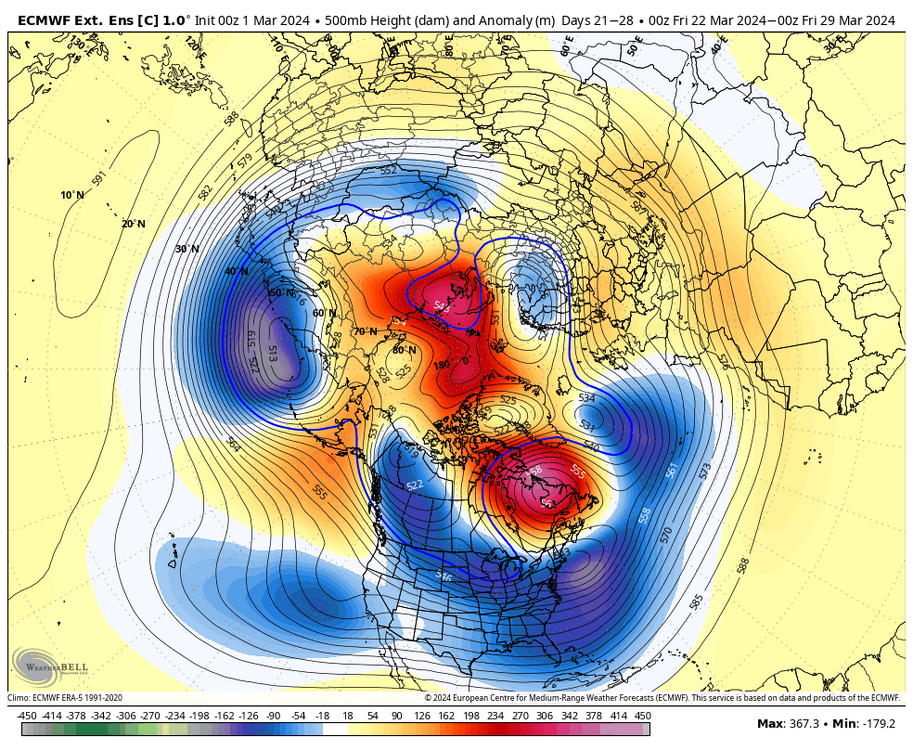
Note the indications of more NS involvement showing up evident from the blue extending into central Canada. I said that bothered me when I saw it showing up a few weeks ago and it was the first step to the pattern breaking down. That increased NS involvement eventually screwed with the -nao. It’s showing up again at the same lead time in the same way.
-
2
-
 1
1
-
-
11 minutes ago, Terpeast said:
That’s what I’m thinking! Fly to Spokane, link up with my bro, and drive up across the border
Schweitzer, Redd, Revelstoke, Panorama and Sun Peaks are all on ikon. If my brother can get a whole week off next winter some combo of those would be my preferred trip.
Southwest has flights to Spokane.
-
1
-
-
14 minutes ago, JenkinsJinkies said:
Still though, the weenies here will be insufferable next winter.
I think it won’t be as bad as the last few years. This year was the final kick in the nuts for most I think. For the last 5 years many who tried to deny how bad it’s getting have said the same thing “wait for a Nino”. That was their hold lot hope. Well we got one, and with a -QBO and solar max no less! And it was the warmest winter ever with below normal snow.
With that last false hope rug pulled I think at this point all except the most insanely delusional few have come to accept our new reality and that 90% of our winters are just going to suck. Sure once in a while we will luck into a 2010 or 2014 or a 2016 type storm but for the most part we should enter every winter with the expectation it’s going to suck ass with way less than “average” snowfall and so as those new expectations set it people won’t complain as much once we all come to accept we are what NC was 20 years ago and snow just isn’t normal here anymore.
The good news is we will eventually get a period with more above Normal snowfall seasons. I grunted it! That’s because at this rate in 20 years our average snow will be like 7” and then these dreg winters will just be normal!
-
1
-
-
3 minutes ago, Blizzard of 93 said:
Lol, I would not have posted in here if that run showed only snow in PA & no snow in MD. I’m not that kind of poster.
It’s not my first day on here…
regardless of the snow maps temps aren’t supportive of accumulating snow for 90% of this region. And that’s on the typically coldest model!
-
1
-
-
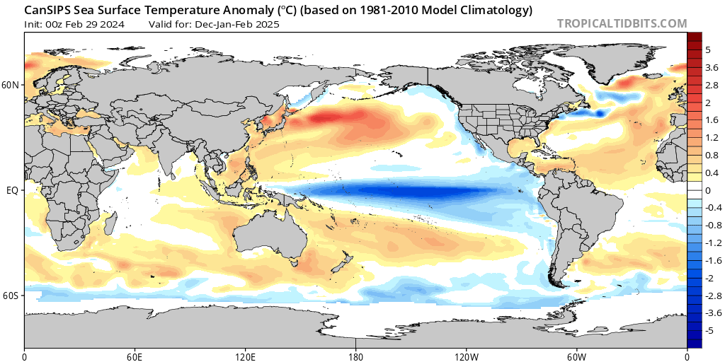
2 hours ago, Terpeast said:
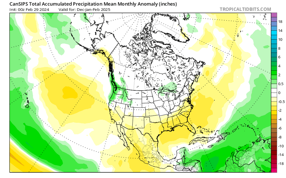
A look ahead to the 2024-25 winter... not for our own backyards, but WHERE to travel and chase (and when):
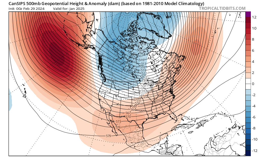
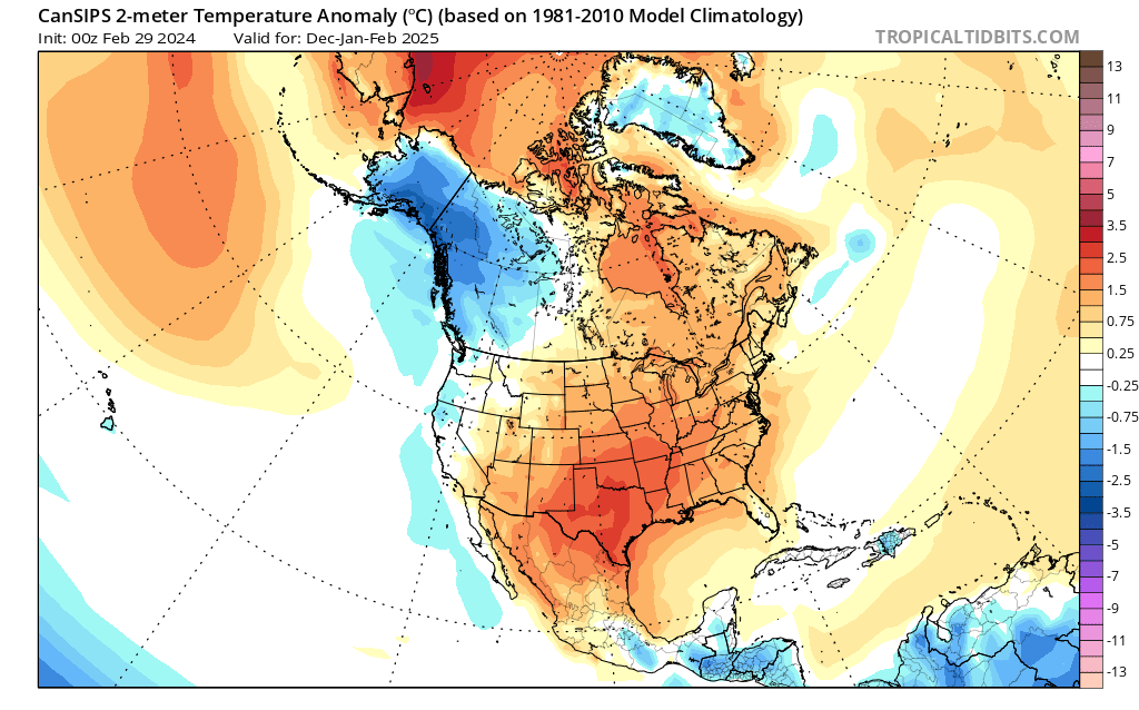
New CanSIPs just came out, and it performed well on a smoothed/seasonal basis for this winter. It showed a wet first half, then a slightly drier second half, and a mostly warm CONUS with near normal/slightly BN southeast.
So here's what it is showing for next winter now...
1) Moderate-strong La Nina, basinwide or even a little bit modoki. MJO should be active in the eastern IO through the MC (phases 3, 4, and 5). Negative PDO signature appears obvious, with that marine heatwave off Japan still ongoing and no signs of ceasing.

2) Standard La Nina h5 configuration enhanced by overall warming with a solid +AO/+NAO (or lack of blocking overall). Take away that -NAO block in December 2022 in the 2022-23 winter, then you'll get a good idea of what this winter is going to be like.
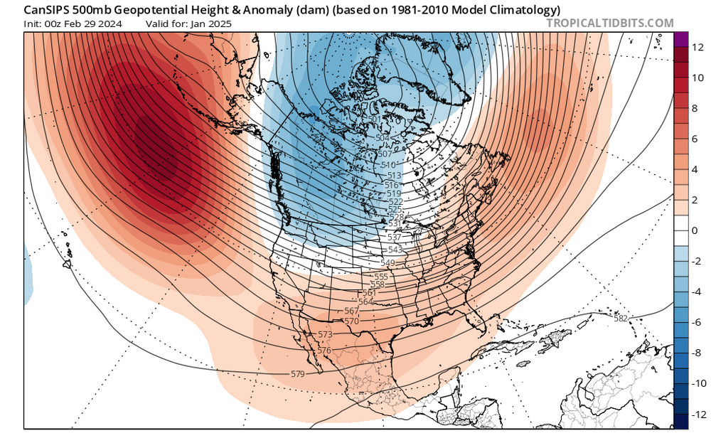
3) Again, a mostly warm CONUS just like this year, except the warmest anomalies are displaced south across New Mexico, Texas, and through the Tennessee Valley. (I wonder what raindancewx has to say about his backyard having the warmest anomalies).
However, the west coast and Pacific Northwest are depicted to have near to slightly below normal temperatures.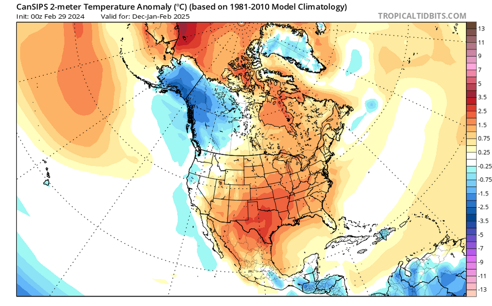
4) Opposite to this winter, the south and southeast are depicted to be drier than normal. It would not surprise me if we got a hot and dry summer, with drought conditions redeveloping across the east.
Wettest anomalies are shown over the Pacific Northwest, and with normal to slightly below normal temps, the mountains in that area could be the best places to chase.My brother lives in Spokane, and they may be set for a great/historic winter next year. Seriously considering an extended two-week visit there, renting a car, staying with him for 4-5 days, then drive to Montana's rockies for a few days, then back. Or if the Cascades are about to get a big one, we could chase there instead.
Again, this is to show you where to plan your chases for next winter, not for snow in your backyards.
Next year might be perfect to hit up the powder highway resorts in BC!
-
5 minutes ago, Terpeast said:
If it were just me, I’d do a pure snow chase with a last minute drive up to new england the night before.
But with the family, probably best to combine with something else like visiting family and/or a ski trip. Some stuff for kids to do, too.
Love Steamboat, but been there 3x. Feels like been there done that want something new.
If the kids ski, something to keep in mind Copper Colorado is the best western resort I think for beginners and mixed ability levels because the mountain progresses from beginner to expert right to left looking at the mountain. And it’s one of the few big mountains where they have a lot of top to bottom runs for beginners. It’s also close to the towns of Frisco, Dillon Breckenridge and Vail and not too far from Denver. And if you want to hit up more than one mountain Winter Park and A basin are within reasonable drives and all 3 are on the ikon pass. Definitely get some kind of pass the window rates are outrageous!
It doesn’t get the most snow. About 300” a year. Some places out west are over 400. But if you’re planning ahead for a set week anywhere out west above like 7000 feet will have a lot of snow on the ground.
-
1
-
 1
1
-
-
13 minutes ago, Kevin Reilly said:
I would think the safe bet would be Lake Tahoe LOL..... I would pick that area.
9 minutes ago, Terpeast said:Safe bet yes, and a very expensive one at that. If it’s possible to get a last minute deal at Tahoe, I’m all ears.
otoh, I can go to Spokane for basically free using points, and if I chase to the cascades, it’ll probably be half the cost of Tahoe anyway
Depends what your goal is. If you just want to see the most snow during a dump then the Tahoe or Mammoth Lakes areas are best. But yes more expensive but for be the biggest issue is it’s also very windy which imo can make heavy snow less aesthetically pleasing. but it also means everything closes including ski resorts.
For me if I’m going out west I want to combine my snow chase with a ski trip. Jackson Hole is a nice town in a snowstorm. Was in Revelstoke when they got like 20” over a few years back. Steamboat is the best Colorado ski town for a snowstorm where they get a lot of snow in town also.
But honestly if you just want a snowstorm chase, at some point there will be a big snow in northern New England. If you like tracking the storm and using radar to pin down a heavy band during..that’s a better bet. Out west it’s all topography and radar is useless.
-
2
-
-
@Ji even this isn’t enough to get snow anywhere near us. It’s all in northern New England.
You would think we would be worried about suppression in this look!
-
This is pathetic
-
1
-
-
2 hours ago, Maestrobjwa said:
So...you gonna track next year? (Real question)
Sure, but only to the same degree that I tracked last year and for the last couple weeks. I’ll take a quick look at the guidance from time to time, but with no expectation of anything good.
-
We just can’t know
-
8 minutes ago, snowfan said:
Next year is going to suck says the same people that thought this year would be above average for snowfall. They have no fng clue how it’s going to play out. And we’ll be right back here tracking.
We learned our lesson. Every winter is gonna suck.
-
1
-
 1
1
-
-
1 hour ago, bwt3650 said:
Hitting both of those and winter park next week. Out of copper and a-basin, which do you think has better trees and what areas to hit? I’m only at each for a couple days.
.IMO it depends on ability level. A-basin has some amazing expert level trees over on the Pallavicini side...but they are extremely challenging. Copper has some better trees for advanced intermediates to advanced but not true expert level. Winter park has the best IMO of the 3 resorts you mentioned. WP has really nice trees in between some of the trails on Mary Jane and especially under the Eagle Wind lift.
-
1
-
-
7 minutes ago, cbmclean said:
I had thought that this was only the 3rd warmest?
That was as of a week ago...its been warm. But also, not sure if his data is the same, what I saw the NWS release might have included Alaska and Hawaii.
-
1
-
-
@powderfreak or anyone else.... I'm pushing hard in rehap from a knee injury to try to get back out by Easter this season...but is there enough base at Subarbush, Stowe, and Sugarloaf for there to be a decent April ski season this year?
-
Just now, WinterWxLuvr said:
In a list of truly shocking developments…
I don't think the Wizards are going to win the championship this year
-
2
-
-
44 minutes ago, Ji said:
you can clearly see the pattern change by 384 hours on GFS
The pattern is changing... but I see some of the same flaws in the "better" pattern that has plagued us for years now even when we get a better longwave configuration. Add in the fact we are talking about late March and we're at the edge of when snow is even reasonably possible and that was before the current torch we've been stuck in for 9 years...I dunno man I am not saying the chances are 0. I realize crazy shit happens. Yes the pattern looks better. But by far the most likely outcome even if we do get a perfect track wave is just another perfect track rainstorm. Snowshoe probably gets a big snowstorm late March or early April. This probably saves the spring ski season for New England...but I am skeptical this does much for us locally.
-
1
-
-
12 minutes ago, WxUSAF said:
89-90, 95-96, 10-11 top analogs.
I heard the winter of 1784BC was biblical and a strong analog
-
2
-
-
1 hour ago, Terpeast said:
@psuhoffman I was just thinking that last year, CA mountains received record snowfall during a La Nina year, and now they are again getting record snowfall during an El Nino year. ENSO doesn’t seem to matter. I think that gives your posts about opposite pacific configurations giving the same western trough eastern ridge more validity than people seem to be giving it. I don’t know if this is caused by CC, or just part of a cycle. We used to have a persistent western ridge eastern trough for years while I was growing up here, and I thought that was a permanent fixture of north american climate. The opposite seems to be happening now, which makes me think it is more cyclical.
Yea, I am definitely NOT saying this is climate change. I don't know. But there has been very little discussion around this phenomenon at all, and that surprises me. I think because it's being written off as part of the larger PDO cycle. And a LARGE part of the western trough eastern ridge is most definitely related to the PDO. Yes the pacific has spend the vast majority of the time in a configuration that is conducive to a western trough eastern ridge longwave pattern.
But there is variance within that. Just like we don't have an eastern trough 100% of the time in a positive PDO there is variability to the pacific pattern in a -PDO. The issue is I've noticed that during the perhaps 30% of the time where the pacific longwave pattern is not such that should amplify a trough in the west, about half that time it still is. Waves are coming in off the pacific and just wanting to amplify in the west regardless of what the upstream pattern is. I am just trying to flag this and start a conversation about it since I think this is part of what's making this period even worse than a typical -PDO cycle.
I threw out 2 factors I can think of. The SER being fed not just by the western pattern but also by the warmer waters downstream could be offering some resistance...and stronger waves coming in off the pacific perhaps making it more likely they amplify sooner and then get stuck in the mountain west due to feedback there. Then you get an awful feedback loop between these 2 factors where the SER slows down the waves some which are already stronger and then they amplify more which pumps the ridge in front more...and UGH.
But I have no idea if that is it. But no one else is even talking about it at all and offering other ideas. I am open to any ideas. I am not really open to the "this isn't actually happening" arguments because I've seen it too often. The waves obviously eventually come east...and its not happening all the time, yes sometimes we get a perfect EPO/PNA ridge that forces a huge trough into the east at times...but quite often even when the longwave configuration in the central and eastern pac would suggest waves should kick east before amplifying they are still amplifying more west first which pumps a ridge in front which means even when they do kick east its not going to work for us because there is too much heat in front of them. I see this...and I see no discussion about it which is frustrating because above all else I want to learn and understand.
-
4
-
-
@jonjonCongrats, I've stopped in a couple times when I took the kids to Blackwater or Timberline but you weren't there...very nice place.
-
46 minutes ago, BristowWx said:
What level of this sucks are we at now? Is there a suckage scale? If not there should be
-
7
-


Late Feb/March Medium/Long Range Discussion
in Mid Atlantic
Posted
Drive through Codorus today, the lake is very low. Surprising, we’ve been reasonably wet.