psuhoffman
-
Posts
27,419 -
Joined
-
Last visited
Content Type
Profiles
Blogs
Forums
American Weather
Media Demo
Store
Gallery
Everything posted by psuhoffman
-

Jan 31st - 33rd Storm Obs and Disco like it's 1979
psuhoffman replied to Bob Chill's topic in Mid Atlantic
Rgem still looks better then the nams at 24 hrs. Can already tell it isn’t blasting that dry slot as far north. Too soon on the ccb yet. -
Jan 31st - 33rd Storm Obs and Disco like it's 1979
psuhoffman replied to Bob Chill's topic in Mid Atlantic
I was strictly talking about the slp track -
Jan 31st - 33rd Storm Obs and Disco like it's 1979
psuhoffman replied to Bob Chill's topic in Mid Atlantic
Yes...but sometimes that actually does happen and it’s not a model feedback error. But it can be, especially on the mesos with this type of setup. -
Jan 31st - 33rd Storm Obs and Disco like it's 1979
psuhoffman replied to Bob Chill's topic in Mid Atlantic
Right or wrong (probably wrong) the NAM is chasing the convection and taking the secondary way too far OTS. It’s improving slightly each run with that but not enough. You can see the slp ride up the line of convection that fires out over the gulf steam vs tucking in along the coastal front baroclinic zone. -
Jan 31st - 33rd Storm Obs and Disco like it's 1979
psuhoffman replied to Bob Chill's topic in Mid Atlantic
That is some crazy divergence from the consensus secondary track and capture location. Not even close. Wow -
Jan 31st - 33rd Storm Obs and Disco like it's 1979
psuhoffman replied to Bob Chill's topic in Mid Atlantic
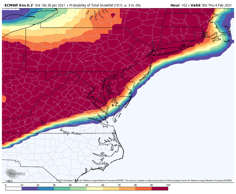
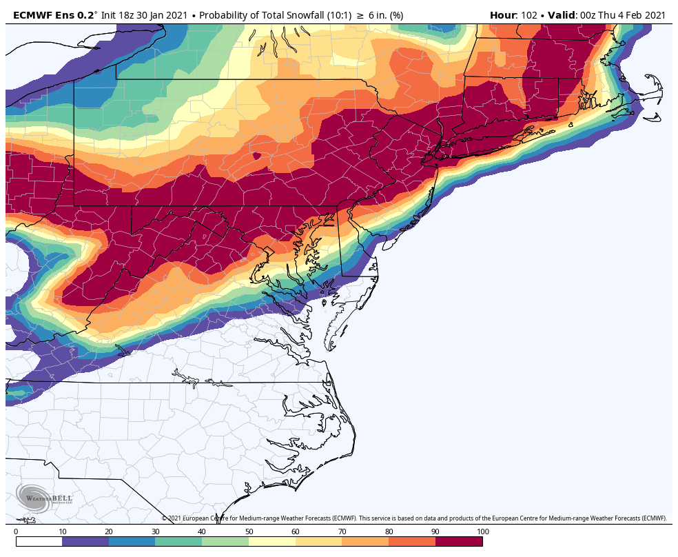
@Weather Will is slacking cue yeoman with “looks like climo”. 6” one isn’t too shabby either keep in mine ensemble members are low resolution and 10-1 so they are going to underestimate snow totals (when you actually do get it lol) if it’s a cold storm or you get under the ccb

-
Jan 31st - 33rd Storm Obs and Disco like it's 1979
psuhoffman replied to Bob Chill's topic in Mid Atlantic
@stormtracker 18z was better then 12z -
Jan 31st - 33rd Storm Obs and Disco like it's 1979
psuhoffman replied to Bob Chill's topic in Mid Atlantic
The qpf increased across N VA and DC and snow mean increased about an inch in DC. Combo of both a little more qpf with WAA and a little better CCB -
Jan 31st - 33rd Storm Obs and Disco like it's 1979
psuhoffman replied to Bob Chill's topic in Mid Atlantic
BIG improvement for N VA on eps. Kinda what I had expected with the op track -
Jan 31st - 33rd Storm Obs and Disco like it's 1979
psuhoffman replied to Bob Chill's topic in Mid Atlantic
Any stalled from Lewis Delaware south should at least get some ccb into DC -
Jan 31st - 33rd Storm Obs and Disco like it's 1979
psuhoffman replied to Bob Chill's topic in Mid Atlantic
That could just be due to the double barrel or strung out low configuration you get as it’s captured and loops. Where exactly the lowest pressure is any any one time isn’t that important. -
Jan 31st - 33rd Storm Obs and Disco like it's 1979
psuhoffman replied to Bob Chill's topic in Mid Atlantic
The euro was about 20 miles too far northeast and way underdone with the ccb in that 2010 example. Fwiw -
Jan 31st - 33rd Storm Obs and Disco like it's 1979
psuhoffman replied to Bob Chill's topic in Mid Atlantic
It’s really consistent. It seems to be where the moisture transport from the secondary is meeting up with the inverted trough from the dying primary and enhanced by instability from convergent winds ahead of the h5 and old h7 lows. The gfs has it too just further northeast and it’s not as sharp since gfs sucky resolution and all. On top of its sucky everything else. -
Jan 31st - 33rd Storm Obs and Disco like it's 1979
psuhoffman replied to Bob Chill's topic in Mid Atlantic
General rule with a miller b capture scenario I remember from model diagnostic sessions with Nese at PSU...and it’s worked almost every time historically and over my years of tracking. The cutoff to the CCB heavy snow band will be sharp and right about the latitude that the storm gets captured. There are also rules regarding how far west it gets but this is tucked in so tight we don’t have to worry about that it’s latitude not longitude that’s potentially going to hurt us. Right now all guidance has the capture due east of DC off the Delmarva. Some 50 miles one way or the other. That’s noise. But it’s significant if that 50 miles means a ccb cutoff at Rt 50 v Rt 70! It’s going to be close. For perspective the evolution of this and the current capture location is very similar to Feb 10 2010 with the exception we have a colder airmass in front so a better WAA wave to start. Now that worked out for DC but it was very close. 20 miles south of DC got a lot less snow. 20 miles north got a lot more! So it doesn’t take much adjustment to that either way to have a very different outcome. -
Jan 31st - 33rd Storm Obs and Disco like it's 1979
psuhoffman replied to Bob Chill's topic in Mid Atlantic
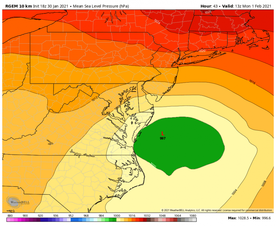
Ehh it’s not that radical. The capture happens around 13z on both the euro and rgem. From that point on the low loops around for about 12 hours gaining very little latitude then extends and splits off a northern extension while the southern fujiwaras back south again. That happens off Wallope Island on the rgem and off Ocean City on the euro. Not that big a difference. But when your right on the southern edge...that little bit matters! But the bigger issue is the better moisture transport on the rgem. If you put that from the rgem onto the euro it would still be better. Not quite as good as the rgem but probably could add on another 3-6” in DC. capture moment on both models Euro RGEM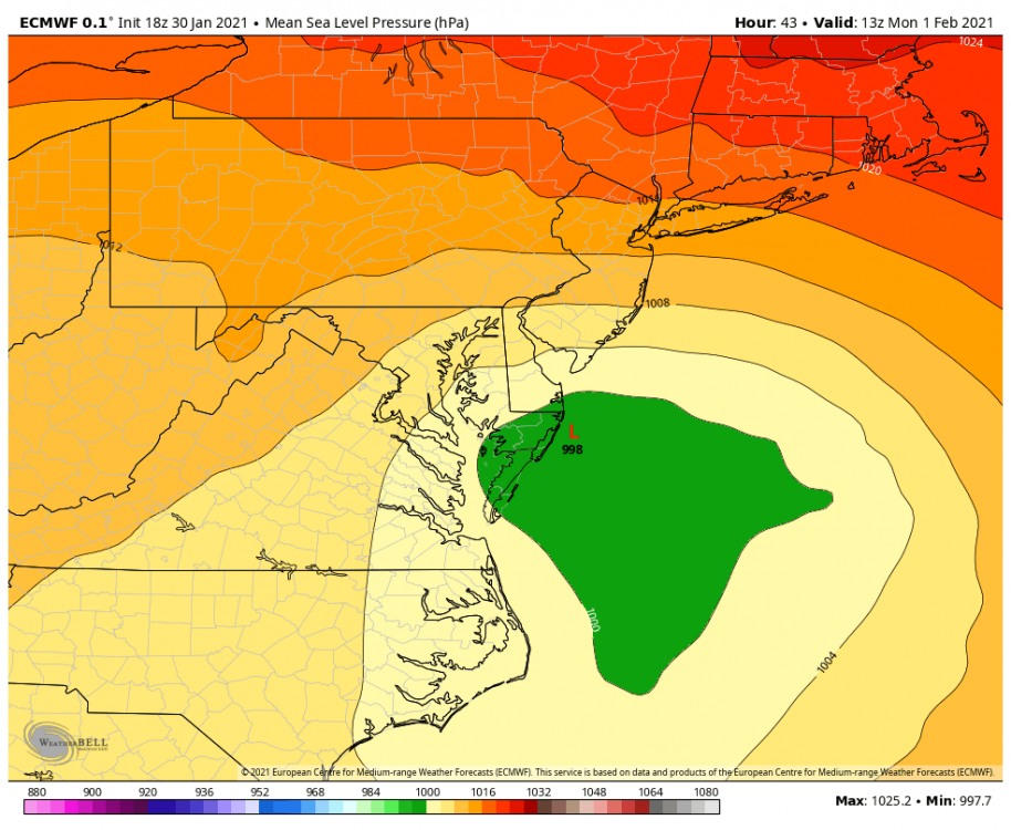
-
Jan 31st - 33rd Storm Obs and Disco like it's 1979
psuhoffman replied to Bob Chill's topic in Mid Atlantic
Euro has that inverted trough feature also it’s just not the main focus like the gfs. -
Jan 31st - 33rd Storm Obs and Disco like it's 1979
psuhoffman replied to Bob Chill's topic in Mid Atlantic
I always liked Canada -
Jan 31st - 33rd Storm Obs and Disco like it's 1979
psuhoffman replied to Bob Chill's topic in Mid Atlantic
@Bob Chill wrt part 2 some of it was seeing that NS vort trending south every run. Had that continued it would have squashed this. And we have lost several good opportunities that way recently. Probably due to the NS dominant fast pac jet pattern increasing odds of a random wave up there to run interference at any given time. And the ONLY way I saw us getting blanked was if the wave gets squashed. Even if the ccb doesn’t Pan out a more amped wave imo meant at the least a 3-6” (probably more) waa snow. Mitigating the risk of explains bare ground to my 2 kids! -
Jan 31st - 33rd Storm Obs and Disco like it's 1979
psuhoffman replied to Bob Chill's topic in Mid Atlantic
Wrt part 1 we have a much better antecedent airmass and it’s Jan 31. Even that storm we don’t speak of would have been a 6” snow in DC with this airmass in front of it. I know that because I did get 6” up here with no more qpf just barely cold enough due to my elevation. -
Jan 31st - 33rd Storm Obs and Disco like it's 1979
psuhoffman replied to Bob Chill's topic in Mid Atlantic
Every meso will have some issues with a secondary transfer at 48 hours. BUT the rgem has been consistent. It also has support from its ggem parent. I also don’t know if it has the same issues with convective feedback I know the NAM does which will really be an issue here. I know our instinct is to go with the model that screws us but so long as the NAM is on its own I think it’s just off on a tangent. -
Jan 31st - 33rd Storm Obs and Disco like it's 1979
psuhoffman replied to Bob Chill's topic in Mid Atlantic
18z rgem held, no crazy dryslot and deforms the hell out of us. Obviously I don’t know if it will show the same insane stupid 3”+ qpf but from this we take!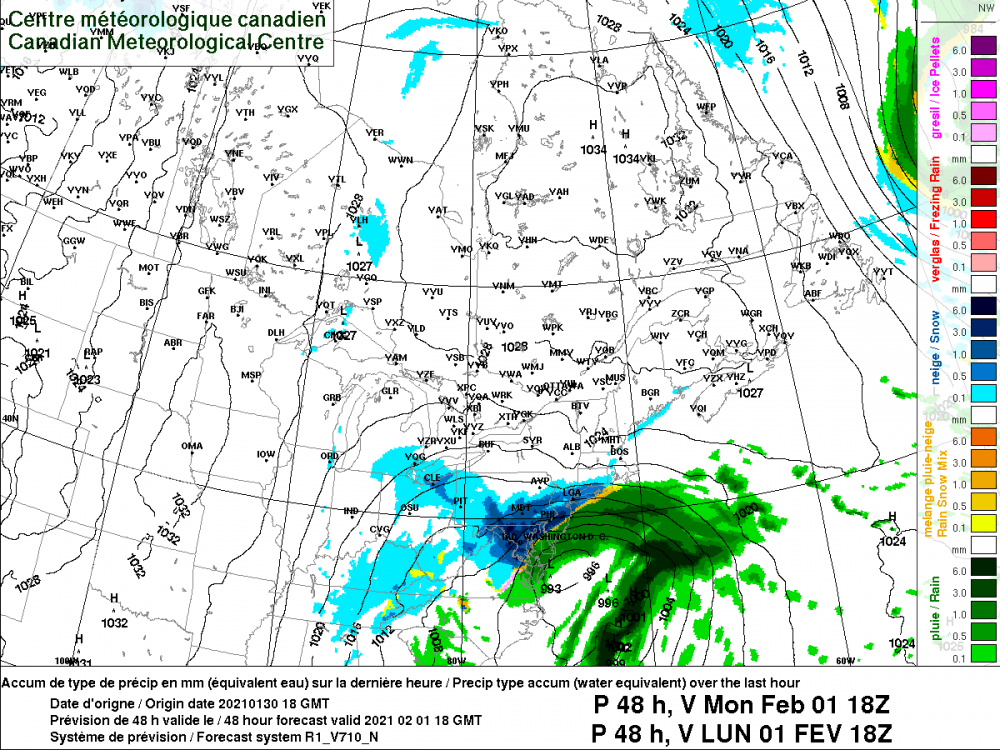
-
Jan 31st - 33rd Storm Obs and Disco like it's 1979
psuhoffman replied to Bob Chill's topic in Mid Atlantic
It really tries but it’s made it pretty hard to activate any kind of deform axis with that dryslot it blasted through. I’ve yet to see it to that extent on any other guidance. -
Jan 31st - 33rd Storm Obs and Disco like it's 1979
psuhoffman replied to Bob Chill's topic in Mid Atlantic
The NAMs really have no ccb anywhere in the mid Atlantic because they blast a huge dry slot through and focus all the coastal redevelopment from NYC northeast along the baroclinic boundary there. -
Jan 31st - 33rd Storm Obs and Disco like it's 1979
psuhoffman replied to Bob Chill's topic in Mid Atlantic
NAM is blasting the dry slot way further NW then any other guidance. Let’s hope that’s just a NAM mirage. Everything else about this run is better. And it’s slightly better with the dryslot but it’s still ugly and will make it hard to really ramp up the deform once the dry air has blasted that far north. -
Jan 31st - 33rd Storm Obs and Disco like it's 1979
psuhoffman replied to Bob Chill's topic in Mid Atlantic
Let’s see what happens the fgen boundary that’s going to become the deform is much further south this run then 12z at the same time in western PA and WV.