

psuhoffman
-
Posts
27,419 -
Joined
-
Last visited
Content Type
Profiles
Blogs
Forums
American Weather
Media Demo
Store
Gallery
Everything posted by psuhoffman
-

Feb Long Range Discussion (Day 3 and beyond) - MERGED
psuhoffman replied to WinterWxLuvr's topic in Mid Atlantic
Didn’t 1996 take FOREVER to advance north or maybe it just felt that way to impatient 17 year old me. -
A few years back there was a very marginal snow and the typical soil temps argument flared up and I didn’t want to admit I had a few inches of snowcover for fear of the mob that might show up with pitch forks.
-
Non paved surfaces have a shot
-
It’s been a few years. There was a noticeable difference once you get north of that first of the 3 ridges that make up Parrs Ridge in northern Carroll. The one that runs right through Manchester. There was much less south of that ridge. Once you get north of Manchester that high valley where Ebb Valley School is and north had a lot more snow. Still my yard being on the north slope of Dug Ridge helps too. Still full coverage here. From my evening walk around the yard an hour ago.
-
I did get about 4” more. It helps that I’m on the north slope of the ridge. Im also 400 feet higher up then Westminster. I know that I am always 3-4 degrees colder then the Westminster Airport which is only 7 miles away. That’s kinda crazy.
-
If a snowflake falls in the forest
-
But the negative hemisphere energy budget -TNH if the +GLAM
-
I went to Westminster today. Legit shocked at the difference in snowcover. I still have 6-10” full snowpack but in town there was barely any with a lot of bare ground. Probably only 60% coverage. Huge difference for only like 8 miles as the crow flies.
-
Feb Long Range Discussion (Day 3 and beyond) - MERGED
psuhoffman replied to WinterWxLuvr's topic in Mid Atlantic
I’m fine with ice so long as I get a good amount of snow under it to turn into a glacier that lasts until Easter. -
Feb Long Range Discussion (Day 3 and beyond) - MERGED
psuhoffman replied to WinterWxLuvr's topic in Mid Atlantic
EPS Probability of 12”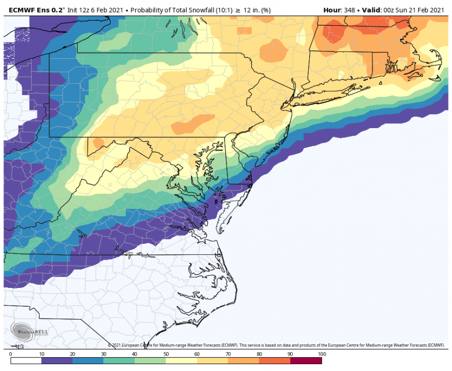
-
Feb Long Range Discussion (Day 3 and beyond) - MERGED
psuhoffman replied to WinterWxLuvr's topic in Mid Atlantic
Dec 2016 I think -
Feb Long Range Discussion (Day 3 and beyond) - MERGED
psuhoffman replied to WinterWxLuvr's topic in Mid Atlantic
What were the next 3 weeks like after that Feb 1960 analog? Asking for a friend. -
Fair enough. I have some mild OCD (legit not joking) so that’s very likely. Radar looks better then guidance att. We can always play that game lol.
-
When a run looks good I’ll weenie out with the rest of you. When things are trending better I am right there celebrating. But I’m not one of the people that does the “let’s lower the bar and pretend there isn’t a bad trend happening and how dare someone point out that said model got worse 4 runs in a row” type person either. Maybe this amps up at the last minute. I expected it too. I see no reason this gets shunted south. But it’s not a positive sign that EVERY guidance we have has trended dryer and more anemic the last 24 hours. Frankly I don’t understand the “don’t say negative stuff” mentality. Ignoring bad trends and warning signs doesn’t make them not real it just sets you up to be disappointed.
-
It’s not like we won’t get snow. I’m not canceling the event. But I guess I let myself get excited when yesterday the NAMs as well as the ICON, UK, and Euro (and all others were trending that way) were showing a dynamic amplified system with some really awesome banding potential. And when these kinds of waves start to trend more amplified it’s rare they suddenly fizzle. Typically that trend carries through the final 24 hours. So I am genuinely disappointed that guidance has since pulled the rug out on that more dynamic memorable scenario and reverted to a weaker more progressive wave. Still going to snow. A lot of people will still be very happy. Don’t let my disappointment at the high end being pulled off the table effect your enjoyment of a snowfall.
-
3k is warmer, dryer, and less amplified. But other then that it’s great.
-
I was looking at 3k. It’s not out far enough yet but man it looks kinda ehh at 8z Sunday compared to prior runs. The difference is a much less amplified trough so there is less moisture transport along the inverted trough with the NS low. The coastal looks about the same but a lot of our qpf was from the interaction with the trough and there is a lot less of that going on this run.
-
Yea but it was the only model still showing a nice upside thump potential. You don’t want to see the most amped guidance trending towards the other more anemic. We want to see the anemic guidance trending towards the NAM lol. That is if we want a 4-8” storm and not a 2-4. I’ll still enjoy a few inches to freshen things up but I was kinda excited for the dynamic thump option we saw on guidance 24 hours ago. This is morphing into a more mundane nice but not memorable snowfall event on guidance today. Which kind of surprises me I honestly expected the amplification trend to continue.
-
NAM looks kinda anemic early on. Hope it amps up quick or this won’t be as good as 12z. Which wasn’t as good as 0z which wasn’t as good as 18z...
-
Remember I work in Baltimore City. I’m well aware of just how amazingly historically awful it’s been for snow there the last 5 years.
-
If I lived where he does I would probably find the worst model every run and obsess over it also. It’s actually somewhat amazing how awful it’s been where he is. Even while the whole area has been in a rut for the last 5 years his area had been by far worse. Got screwed by every storm. Literally. While some east locations got the Jan 18 and March 18 storms and westerners got March 17 and 18 and December 20 and DC got the Jan 19 storm he got the screw zone of EVERYTHING. He hasn’t seen a warning event since 2016! So yea he is being a deb. But I might have had a nuclear meltdown if I was in his position by now.
-
Hope you don’t mind but moved this over from the other thread since it’s more pertinent here. Agree with both above. There are no comp examples I can think of where a wave like this sunk southeast at the last minute. The examples you cited like March 2014 and Feb 2015 had true Arctic air pressing and a TPV centered further east really compressing the flow. I can’t think of a single example of an amplifying wave with nothing but southwest flow and no vortex to the northeast that didn’t trend north some at the last minute. But I guess if you pay attention long enough there is a first for everything. But that’s why I was kind of surprised to see guidance shift a little southeast the last 2 runs but there is still time. I do expect it to juice up some later today and tonight.
-
Part of that is due to models being much higher resolution then before. The differences are in these meso banding that guidance couldn’t have even seen 20 years ago. Everything would have looked smoothed like the JMA on TT. Then we had to use climo and history to guess at the meso features. And in some ways maybe that was better. If you know how to actually use the models correctly and adjust it’s good but if you’re a weekend weather worrier who just rips and runs with a model verbatim having these details shift around on every model every run will drive you crazy.
-
Feb Long Range Discussion (Day 3 and beyond) - MERGED
psuhoffman replied to WinterWxLuvr's topic in Mid Atlantic
I know. I said I expect it might juice up at 18/0z but all anyone seems to see is “he said it’s going to fail” because I pointed out the 12z guidance was dryer and why that wouldn’t be good.


