

psuhoffman
-
Posts
27,417 -
Joined
-
Last visited
Content Type
Profiles
Blogs
Forums
American Weather
Media Demo
Store
Gallery
Everything posted by psuhoffman
-
I just noticed something in my data that has bugged me for a while and I think now I know why. The Feb storm in 1978, Westminster only recorded 7" but based on other reports in the area it should have been closer to 10". It made it hard for me to estimate what my area got since it was incongruous with the expected gradient and created a huge difference between the stations on either side of me. I don't know why I never noticed it before but the snow depth reported increased from 4" before the storm to 13" the day after. The only way that is possible is if at least 9" fell from the storm. Probably more to account for compaction. So their report of 7" is simply an error.
-

Jan Medium/Long Range Disco: Winter is coming
psuhoffman replied to stormtracker's topic in Mid Atlantic
@brooklynwx99 the gefs ext confirms my point. The look at the end of the gefs was not a temporary transient problem. This is where it leads one week after the gefs ends and two weeks later and it still looks like garbage into Feb. I am not saying I agree with it. Just saying don’t sugar coat it. That look is god awful, just hope it’s wrong. Once a central pac ridge goes ape like that it’s a season wrecker most of the time! I’m not a sugar coat things kinda person. If that’s correct we busted and this season is not what we expected. The good news is simply it’s still at a range we can hope it’s just wrong. -
Jan Medium/Long Range Disco: Winter is coming
psuhoffman replied to stormtracker's topic in Mid Atlantic
yes but in this case I think the wave spacing is a limiting factor also... I would still be a little nervous this gets squashed but its looking like it has more of a chance this run. The spacing is still tight. -
Jan Medium/Long Range Disco: Winter is coming
psuhoffman replied to stormtracker's topic in Mid Atlantic
Icon was Jaws music worthy at the end of the run -
Jan Medium/Long Range Disco: Winter is coming
psuhoffman replied to stormtracker's topic in Mid Atlantic
The CMC isnt as deep with the western trough and kinda cuts it off which leaves just enough room for the system to amplfy some in the east...but its still close and notice it quickly gets suppressed and slides southeast once to our latitude. Its still extremely tight spacing. GFS does the same...the wave starts up then gets washed out. We could use a little more breathing room there. -
Jan Medium/Long Range Disco: Winter is coming
psuhoffman replied to stormtracker's topic in Mid Atlantic
I know...if it wasnt so far out I would even dig into the fact its wrong in fringing me based on the surface and upper level locations but whatever. -
Jan Medium/Long Range Disco: Winter is coming
psuhoffman replied to stormtracker's topic in Mid Atlantic
I predicted 30-40" of snow this year. people hear what they want to hear. -
Jan Medium/Long Range Disco: Winter is coming
psuhoffman replied to stormtracker's topic in Mid Atlantic
best part is it fringes me -
Jan Medium/Long Range Disco: Winter is coming
psuhoffman replied to stormtracker's topic in Mid Atlantic
2 for 2 so far -
Jan Medium/Long Range Disco: Winter is coming
psuhoffman replied to stormtracker's topic in Mid Atlantic
They were not snowy at all here. What I think the data on the whole shows if you dig in and really analyze it...places further north and colder are seeing their means increase. Burlington VT for example...and even some places that have been JUST far enough north to take advantage of the stormier base state. Philly and NYC. But there is a stark line near 40 where south of there snowfall is tanking. -
Jan Medium/Long Range Disco: Winter is coming
psuhoffman replied to stormtracker's topic in Mid Atlantic
What's sobering, and I already knew about that look...4 of the top 5 analogs to that pattern didn't go anywhere good and lead to total dreg seasons. It's not a look you want to F with. -
Jan Medium/Long Range Disco: Winter is coming
psuhoffman replied to stormtracker's topic in Mid Atlantic
IMO our best hope is that as the MJO progresses (if) back into the central pacific it kicks the ridge out and we re-establish a trough near the Aleutians. Then we would get a split flow with the western energy cutting under the block into the east. The timing of that is now betting pushed back towards February though realistically. That's still plenty of time though...for anyone still left alive after the blood bath this place will turn into by then! -
Jan Medium/Long Range Disco: Winter is coming
psuhoffman replied to stormtracker's topic in Mid Atlantic
I think his data is running a 50 year regression not using the 30 year averages, plus its possible those were localized anomalies due the lake effect that might not show up on that coarse map. -
Jan Medium/Long Range Disco: Winter is coming
psuhoffman replied to stormtracker's topic in Mid Atlantic
Look at the December 1982 SST anomalies. That was one of the most east based nino's ever. I would think we should get a more prolonged favorable pattern. That year was similar to 1998 except we got just cold enough at just exactly the right time to get one of the precip bombs to be snow. Again, if this season fails its not because of enso.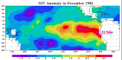
-
Jan Medium/Long Range Disco: Winter is coming
psuhoffman replied to stormtracker's topic in Mid Atlantic
Yes but a basin wide event like 2003, 2010, and 2016 is significantly more favorable for us historically than a more east based event like 1998 or 2007. By including them with the pure east based events it skews the data imo. Pure east based Nino's are pretty bad but this is clearly NOT that. It's not a pure modoki but frankly I see little distinction between the modoki and basin wide. There are some that have mistakenly characterized basin wide as modoki. 2015 and 2005 were pure modoki seasons and 2003, 2010, and 2016 were snowier on average in the mid atlantic. -
Jan Medium/Long Range Disco: Winter is coming
psuhoffman replied to stormtracker's topic in Mid Atlantic
If we can get the pac to back off at all I think our chances are high still. I am acknowledging I am more nervous now than I was a month ago but I have by no means given up and put together my "time of death" winter call yet. I still think this works out. Just less sure than I was. As for the age thing...yea its frustrating but I can compartmentalize. I come on here, track, kill time, and in the moment when I analyze and dont see what I want its frustrating...then I log off and go do other stuff and it doesn't affect me at all. -
Jan Medium/Long Range Disco: Winter is coming
psuhoffman replied to stormtracker's topic in Mid Atlantic
He is trolling you, not worth it. -
Jan Medium/Long Range Disco: Winter is coming
psuhoffman replied to stormtracker's topic in Mid Atlantic
Cascades and Canada. Brian Brettschneder shared this on twitter last year. It's pretty bleak. The positive anomalies along the east coast are due to all those HECS storms from 1996 to 2016. The median is tanking here though for sure and if we don't get another HECS soon that blue will disappear, might have already given the last season isn't factored into that. -
Jan Medium/Long Range Disco: Winter is coming
psuhoffman replied to stormtracker's topic in Mid Atlantic
came in like a bull in a china shop eh -
Jan Medium/Long Range Disco: Winter is coming
psuhoffman replied to stormtracker's topic in Mid Atlantic
I generally agree with your points but this chart isnt totally applicable because this is not an east based Nino. It's a basin wide nino. Look at my last post above at the current anomalies compared to two recent basin wide events. Nearly identical. -
Jan Medium/Long Range Disco: Winter is coming
psuhoffman replied to stormtracker's topic in Mid Atlantic
Nobody and I mean NOBODY said this was a Modoki/CP nino. It is a basin wide though NOT east based like some of the warminista crew is trying to classify. By far the two best matches wrt the composition (not the strength but WHERE the anomalies are located) are Dec 2009 and 2015. 2009 was weaker and 2015 was stronger but both were almost identical in terms of the way the enso anomalies were situated. And both featured a reasonably cold January in the east, or at least some pretty good periods. If this season goes off the rails it wont be because of enso, it will be because of other factors. Now Dec 2015 Dec 2009 -
Jan Medium/Long Range Disco: Winter is coming
psuhoffman replied to stormtracker's topic in Mid Atlantic
Thanks for this. Our best hope is still when the mjo cycles back to 8/1/2. Just a thought that was in the back of my mind but I kept to myself because I didn’t want to contradict my forecast or start a shitstorm but since the thread is a total disaster now anyways… what if the warmer pacific has set up a no win scenario when a jet extension floods the continent with pac puke but a jet retraction leads to a super pac ridge which creates a deep -pna. Neither works for us. -
Jan Medium/Long Range Disco: Winter is coming
psuhoffman replied to stormtracker's topic in Mid Atlantic
Yes, back in 2019 they teased us with a constant epic -nao eastern trough look that was forever 20 days away. Sometimes it would get as close as day 12 or so then suddenly morph into the -pna look and we were back to day 20. We kept falling for it through December and early Jan. Then when they did one more rug pull mid January was when I think we all caught on. The weeklies continued to tease the good pattern day 20+ through Feb but we started to ignore it by then. It never came to fruiting. The Nina base state kept shifting it towards the pna TNH pattern. -
Jan Medium/Long Range Disco: Winter is coming
psuhoffman replied to stormtracker's topic in Mid Atlantic
It is what it is. I've seen troubling signs that have started to make me a little nervous regarding my expectations for this winter for a while now. But I tried to keep it on the down low because I knew what the reaction would be. Unfortunately I've been on here way too long and everyone knows my tells, and I am not particularly good at hiding my thoughts. I am not convinced it's all going sideways yet. There is time to pull out of this. Maybe, just maybe, the pacific ridge is temporary and we simply can't see past it yet. I did think that honestly and still think its a strong possibility. But the amplitude of that ridge is starting to really go ape on the long range guidance, and the forcing is getting stuck in the MC again like the last few years. Frankly I am seeing a lot of similarities to what happened in 2019 and it bothers me. We did "OK" wrt snowfall that year but a lot of that came early in January during a flux in the pattern, once the pacific ridge set in it was pretty crappy the rest of the winter. The euro is better but honestly I don't love where its trending either. I think your weeklies post was legit and I don't know why so many took issue with it. The weeklies for a long time showed the pattern we wanted setting in by late December. Then it pushed it to mid January. And now its punting January but has that look in February. That pattern disturbs me, its exactly what happened in 2019. I know the running theory, and I fully bought into it also so I am at fault here too, was that the issue was the nino was too weak. But what if the issue has nothing to do with enso and we are trying to mitigate something with other things when the only solution is for the root cause to stop which is more rooted in the pattern AROUND enso not enso itself! -
Jan Medium/Long Range Disco: Winter is coming
psuhoffman replied to stormtracker's topic in Mid Atlantic
this seems to be the exact kind of post I said didn't belong in this thread, but thanks. You could have told me this in banter or the "will it snow again" thread. My main post was purely about the pattern... then we get 500 replies about what our expectations should be or whether I am being fair holding us to whatever "good" standard I used to pick my analog pattern. Then I reply and get told I am derailing the thread.


