

psuhoffman
-
Posts
27,419 -
Joined
-
Last visited
Content Type
Profiles
Blogs
Forums
American Weather
Media Demo
Store
Gallery
Everything posted by psuhoffman
-

Jan Medium/Long Range Disco: Winter is coming
psuhoffman replied to stormtracker's topic in Mid Atlantic
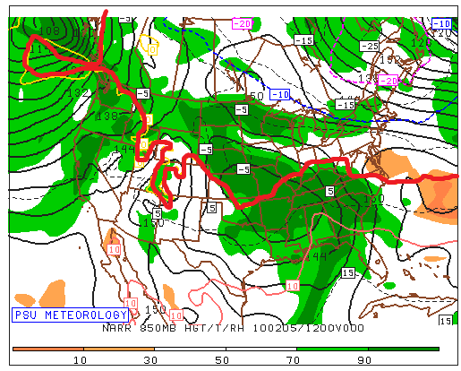
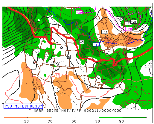
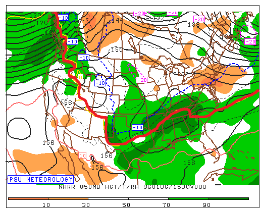
This kind of proves my point...that the temps are the most important issue...the thing I don't get is you act like its a given we will always have temp problems...NO its not...There are plenty of times we had a cold enough antecedent airmass in place that was....wait for it...5-10 degrees colder than the one forecasted this week. And that's why it snowed those times and why it might not this time for many places! Look at where the thermal boundary is at 850 and surface as the wave approaches Surface 850...and look where the REAL cold boundary is This is NOT what we want or need the thermals to look like as a wave begins its final approach...the WAA hasn't even kicked into high gear yet and were already too warm! We are left relying on everything else to be absolutely perfect to make up for the one main deficiency. Look at what we WANT the thermals to look like as a strong wave approaches us from the southwest...just so we can remember what COLD ENOUGH looked like, what we actually want the thermals to look like. January 1996 Ok maybe this isn't fair...it's one of our colder big storms and during a Nina. So here is a storm in another strong Nino during a very "warm" winter...at least by those days standards Feb 1983 And finally...Feb 2010 and at the time this was considered to be a marginal airmass! I remember about 5 days before that event I was discussing with Wes weather the airmass would be cold enough, he thought it was problematic and we were debating if with a perfect track it would be able to overcome the "questionable" airmass... so this was considered marginal and the bare minimum of what we need to be cold enough to snow Still miles better than what we have leading up to this event on guidance. So we could be super picky and analyze what we need from the SLP track and the upper low and the exact amplitude of the wave and the exact composition of the 50/50 and the western trough....but the one obvious flaw that makes it so that we need all that other crap to go 100% perfectly for us to get a big snow in DC is that its NOT COLD ENOUGH. BTW the reason I have been saying this a LOT lately is because its been true a lot lately and its why its not been snowing much the last 7 years. This is the least edgy controversial thing Ive ever said. Its a melba toast comment. Its like DUH. There is no mystery to why we haven't been snowing as much lately. THIS IS WHY...Temp anomalies Dec-Feb last 7 winters ITS THAT SIMPLE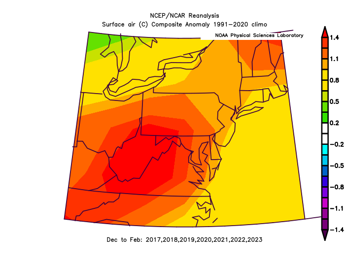
-
Jan Medium/Long Range Disco: Winter is coming
psuhoffman replied to stormtracker's topic in Mid Atlantic
I’m going to have to go into hiding if this happens. -
Jan Medium/Long Range Disco: Winter is coming
psuhoffman replied to stormtracker's topic in Mid Atlantic
There are plenty of storms where a colder antecedent airmass wouldn’t matter because the storm is likely to cut way west of us no matter what the temps in front are based on the flow. But more importantly when we actually do get snow (I know crazy thought) often there was a good enough antecedent airmass that another 5 degrees wouldn’t help. Might even hurt! Its just been so long…but our last snowy month January 2022, not the first wave as the cold arrived that was crazy and unusual…but the rest of the snow that month it was plenty cold. Maybe too cold! Maybe that one coastal bomb doesn’t miss us if it’s not so cold. And 5 degrees colder wouldn't have helped on the MLK weekend snow to rain event either. It was plenty cold. That’s why we got decent snow with an inside track. The issue was the primary cut due to where the upper low cut off and the trough axis. The mids were doomed regardless. But if you put the airmass we’re likely to have next week in front of that storm and places west of 95 that got a 2-4” snow likely get nothing from that same setup! A colder airmass gives us more wiggle room for all these variables to be less perfect and still snow. I know it seems like we never have that lately…and we haven’t…but guess what THATS WHY ITS NOT SNOWING. This isn’t some freaking mystery. The snow gods don’t hate us. We’re not just getting unlucky. It’s not snowing because it’s just not been cold enough 90% of the time recently! -
Jan Medium/Long Range Disco: Winter is coming
psuhoffman replied to stormtracker's topic in Mid Atlantic
I’m talking about the DC Baltimore area. You’re a whole different world. And i never said I ever thought it would be colder. I’m just saying if we wanted to make this setup much more likely to end up snowy for DC v just a possibility if a bunch of stuff breaks right…having a colder antecedent airmass if the one variable that would do that. That’s not even controversial. Im not even sure what you’re taking issue with. -
Jan Medium/Long Range Disco: Winter is coming
psuhoffman replied to stormtracker's topic in Mid Atlantic
I don’t know. But I know with the marginal thermal situation we need everything else to break near perfectly. 50/50 isn’t perfect rain. SW too amplified rain. Surface track inside at all…rain. I guess you can focus on all those variables but the one simple thing that would change all this in our favor would be if the airmass was maybe 5-10 degrees colder. -
Jan Medium/Long Range Disco: Winter is coming
psuhoffman replied to stormtracker's topic in Mid Atlantic
I think the biggest problem is the antecedent airmass just isn’t cold enough for a good but somewhat flawed setup to work. We could over analyze whatever little thing causes this or that. But systems will try to find the real thermal boundary. And the boundary with the best gradient is to our north. -
Jan Medium/Long Range Disco: Winter is coming
psuhoffman replied to stormtracker's topic in Mid Atlantic
The gefs is trending warmer also. -
Jan Medium/Long Range Disco: Winter is coming
psuhoffman replied to stormtracker's topic in Mid Atlantic
On the positive side if this goes sideways at least we won’t have to hear all the complaining when the snow gets washed away 2 days later by the cutter. -
Jan Medium/Long Range Disco: Winter is coming
psuhoffman replied to stormtracker's topic in Mid Atlantic
Technically the day 5 and 7 scores say it’s Euro, UKMET, CMC, GFS. Anecdotally the uk seems to struggle with east coast storms though. Doesn’t mean it’s wrong now though. -
Jan Medium/Long Range Disco: Winter is coming
psuhoffman replied to stormtracker's topic in Mid Atlantic
Omg the copium is out of control. Why do so many gravitate to one extreme or the other. There is either no trend and everything looks awesome because we should ignore anything that looks bad and just look at wherever still shows a good track. Or…it’s over these always trend north and this has no chance. Reality: The trend isn’t good, these do usually trend north, this isn’t where we ideally want to be, but they don’t always trend north. There are things that could reverse the trend. I’d say it’s 30/70 against us but that’s not hopeless and definitely still worth tracking. And obviously places further NW have a better chance than that here. Our best shot to reverse this would be for the 50/50 to trend more amplified and further SW. -
Jan Medium/Long Range Disco: Winter is coming
psuhoffman replied to stormtracker's topic in Mid Atlantic
You can go hunting for obscure data to support anything. Or you could loop the last 3 runs of the Euro, GFS and CMC and see a clear trend. It could turn around but we all know that’s not the most likely outcome. Why set yourself up for disappointment? If this is one of those 30% that things don’t trend north for some reason (we get lucky and the 50/50 goes ape or the NS phases in a better location) then we can be happy. But denying the clear trend and expecting the least probable outcome seems to just be setting us up for a bad bad meltdown. -
Jan Medium/Long Range Disco: Winter is coming
psuhoffman replied to stormtracker's topic in Mid Atlantic
CMC looks good NW of 95 but this is heading the wrong way at this range. We’re way too far out to already be fighting the R/S line. The bias isn’t as bad as it once was but in my experience more often things still trend slightly north on these the last 100 hours. -
Jan Medium/Long Range Disco: Winter is coming
psuhoffman replied to stormtracker's topic in Mid Atlantic
Time to plan my chase -
Jan Medium/Long Range Disco: Winter is coming
psuhoffman replied to stormtracker's topic in Mid Atlantic
Gfs is going to be a disaster I think. Hope I’m wrong -
Jan Medium/Long Range Disco: Winter is coming
psuhoffman replied to stormtracker's topic in Mid Atlantic
Because it’s been so cold otherwise lately. Snark aside it was just an observation. It’s Jan 7. We’re 10 days into a better pattern by then. Perfect storm track. Ya the icon thermals are probably a couple degrees too warm, and that would still be marginal for DC and that’s sad with that track on Jan 7. -
Jan Medium/Long Range Disco: Winter is coming
psuhoffman replied to stormtracker's topic in Mid Atlantic
Those temps are kinda depressing with that track. -
Jan Medium/Long Range Disco: Winter is coming
psuhoffman replied to stormtracker's topic in Mid Atlantic
Good. I’m more concerned with too amped than south att. Not saying suppressed isn’t possible also, there is a squeeze play going on. But given recent history warm seems the bigger threat than suppressed. FWIW 6z eps at 144 was interesting. More NS interaction and more amped but also more space out west. Not sure how that would have played out. -
Jan Medium/Long Range Disco: Winter is coming
psuhoffman replied to stormtracker's topic in Mid Atlantic
Remember the days when we complained about getting only 10” before mixing or a dryslot!!! -
Jan Medium/Long Range Disco: Winter is coming
psuhoffman replied to stormtracker's topic in Mid Atlantic
At least your area did do a little better than most in the first 2 HECS storms that season. -
Jan Medium/Long Range Disco: Winter is coming
psuhoffman replied to stormtracker's topic in Mid Atlantic
Feb 2006 -
Jan Medium/Long Range Disco: Winter is coming
psuhoffman replied to stormtracker's topic in Mid Atlantic
@Ji Case in point there have been 11 snowstorms of greater than 15” here since 1980. Every one of them was also a big storm for you. We share the same big storms. Jan 96: 36” Feb 11 2010: 30” Jan 2016: 28” Feb 2003: 28” Feb 83: 28” Feb 5 2010: 27” Feb 2014: 23” Dec 2009: 18” Feb 1987: 18” March 93: 17” Feb 2006: 16” -
Jan Medium/Long Range Disco: Winter is coming
psuhoffman replied to stormtracker's topic in Mid Atlantic
There are flaws in this setup. The antecedent airmass is marginal. The storm crashing into the west is trying to pump. Ridge in the east. There is a -nao but not a true block. The only hope we have to suppress this is the 50/50 and we need some NS interaction. It’s not the typical Nino “easy” setup where a split flow stj wave is coming at us with cold in place and ridging out west and a block. It’s not an awful setup, if the 50/50 trends SW or the NS interaction improves we can win, but I could see this becoming a ski resort storm if those details don’t break our way. As for what I want my best storms are when you get crushed also. The bullseye right over DC to Baltimore is perfect. I get more simply due to better ratios and enhanced precip from upslope orographic effects. If DC and Baltimore are rain I can get a pretty good snow here but it’s not gonna be 12”+. This is further NW than I want it for me here at this range. Sure I could salvage a few inches here if this goes sideways where as DC might be totally screwed but why would I root for that over all of us getting destroyed. . -
Jan Medium/Long Range Disco: Winter is coming
psuhoffman replied to stormtracker's topic in Mid Atlantic
So several times over the last several years the euro was all by itself showing snow. And of course each failed. And I opined that while it’s still better it’s not so much better anymore than it’s likely to be correct when it’s on an island in opposition to the preponderance of guidance. This is the first time we get to test that but in the opposite way. -
Jan Medium/Long Range Disco: Winter is coming
psuhoffman replied to stormtracker's topic in Mid Atlantic
with that western trough if the 50/50 relaxes it will. -
Jan Medium/Long Range Disco: Winter is coming
psuhoffman replied to stormtracker's topic in Mid Atlantic
It’s only out to day 13 for me but from what I can see it doesn’t bother me as much as yesterday’s runs. The block is more west based and there is a trough closer to where we need it in the pac. Adjust the north pac a bit and that goes from meh to great easily.


