

psuhoffman
-
Posts
27,417 -
Joined
-
Last visited
Content Type
Profiles
Blogs
Forums
American Weather
Media Demo
Store
Gallery
Everything posted by psuhoffman
-
Early on I thought the less amplified wave might help mitigate the thermals but we need the NS interaction. I was wrong.
-
This is the issue…weaker less dynamic system.
-
Heisy was right. Upon closer look the euro went to a gem like solution. The biggest difference is the system is much less amplified. There is almost no NS interaction. The stj wave runs out ahead alone and the NS hangs back. That kills us. That NS interaction was pulling cold in tighter to the system. The track on 6z eps control and mean is better but without the NS and less confluence (I think those are related) WAA warms the thermals way ahead of the wave and the cold doesn’t wrap in behind. That isn’t a fluke on the control it showed up across the eps members. They really lost the NS interaction. Seems that’s the key here and it seems linked to the confluence. Not enough suppression and the NS doesn’t dig enough to interact with the STJ wave.
-
They switched positions
-
I can’t dig too deep, work. But the track is identical. The mean is weaker also. It’s just warmer. Less confluence and high slides east. That is the most important thing unfortunately.
-
I was looking at the control which is worse so op would probably have been a bad run. EPS is warmer too but not as much. Bad run. control eps
-
EPS is awful. Warmest run in 3 days
-
SW is a little more progressive and less amplified. Also a little colder over the top despite the true arctic boundary retreating a bit. Might be a wash.
-

Jan Medium/Long Range Disco: Winter is coming
psuhoffman replied to stormtracker's topic in Mid Atlantic
Euro op is around 3 for DC and it’s the slowest of all guidance right now. -
Jan Medium/Long Range Disco: Winter is coming
psuhoffman replied to stormtracker's topic in Mid Atlantic
EPS -
Jan Medium/Long Range Disco: Winter is coming
psuhoffman replied to stormtracker's topic in Mid Atlantic
We’ve actually had some runs with marginally crappy tracks produce decent results over the last 24 hours. This helps. Remember a few days ago what the airmass looked like leading in. The boundary was to our north. This is much closer to what we want the thermal boundary look look leading in. I said I wanted 5 degrees colder than that gfs run. This is maybe 3-4 colder. Will have to do.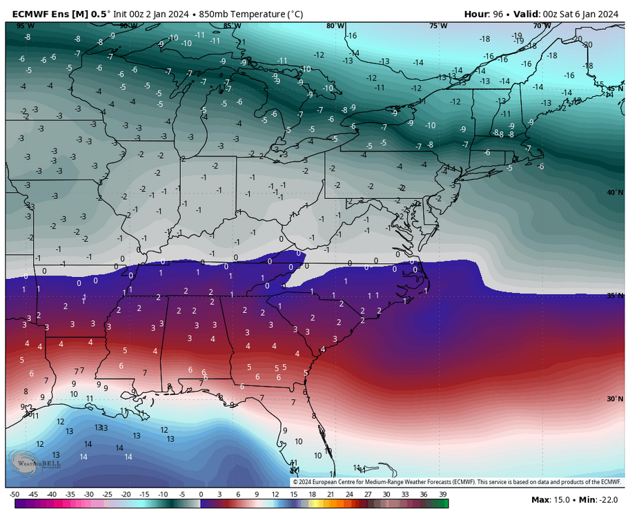
-
Jan Medium/Long Range Disco: Winter is coming
psuhoffman replied to stormtracker's topic in Mid Atlantic
Not so subtle…definitely colder -
Jan Medium/Long Range Disco: Winter is coming
psuhoffman replied to stormtracker's topic in Mid Atlantic
Subtle but eps is slightly colder Saturday morning leading into the event. -
Jan Medium/Long Range Disco: Winter is coming
psuhoffman replied to stormtracker's topic in Mid Atlantic
That area should do very well. -
Jan Medium/Long Range Disco: Winter is coming
psuhoffman replied to stormtracker's topic in Mid Atlantic
I think the gefs is starting to cave in the long range. -
Jan Medium/Long Range Disco: Winter is coming
psuhoffman replied to stormtracker's topic in Mid Atlantic
-
Jan Medium/Long Range Disco: Winter is coming
psuhoffman replied to stormtracker's topic in Mid Atlantic
lol. We are not locking anything in. But I will say I’ve observed in the last few years since the major upgrades to the gfs and euro, there is a pattern where they start to narrow in on the general synoptic solution around 140-160 hours out. After that the changes are more subtle. We’re marginal so subtle could be big for our ground truth but once inside day 6 usually it’s not adjustments of 500 miles like it used to be. They even picked up on that crazy anafront wave from 5-6 days out! They still have limitations but since the last upgrade they seem to start identifying the basic idea a couple days earlier than before. I know we haven’t had many chances to test this locally but I’ve tracked storms for my various ski interests over the last few years. -
Jan Medium/Long Range Disco: Winter is coming
psuhoffman replied to stormtracker's topic in Mid Atlantic
The mids are fine at DC. Never gets close. But surface is 34-35 up 95 during the whole event. That’s not usually how this goes. Typically if anything the mid level warm later pushes further NW than the surface. If the euro is 2 degrees too warm at the surface this was a 12” snow in DC and Baltimore. I won’t say it. -
Jan Medium/Long Range Disco: Winter is coming
psuhoffman replied to stormtracker's topic in Mid Atlantic
I didn’t want to overstate it. I’ve make early observations then a run went sideways. But very early on it looked better over the top. Better confluence. Colder antecedent airmass. -
Jan Medium/Long Range Disco: Winter is coming
psuhoffman replied to stormtracker's topic in Mid Atlantic
Oh it’s COLDER leading in -
Jan Medium/Long Range Disco: Winter is coming
psuhoffman replied to stormtracker's topic in Mid Atlantic
I want to say I have a good feeling but don’t want to jinx it. Looks colder. -
Jan Medium/Long Range Disco: Winter is coming
psuhoffman replied to stormtracker's topic in Mid Atlantic
At 84 hours euro has slightly better confluence ahead of the wave than its 12z run. Still early though. -
Jan Medium/Long Range Disco: Winter is coming
psuhoffman replied to stormtracker's topic in Mid Atlantic
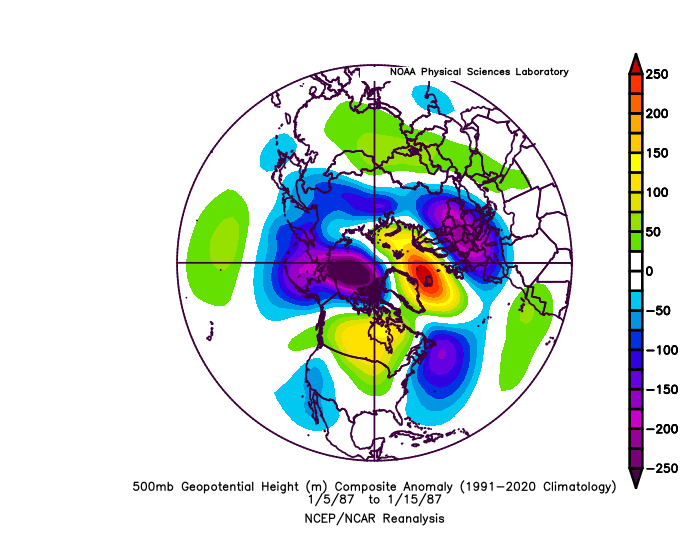
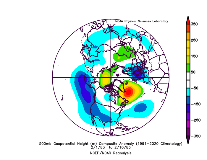
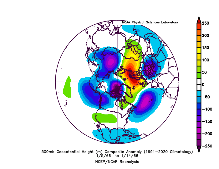
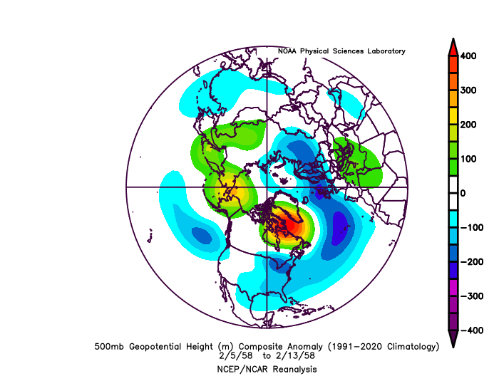
We are very likely going to get another jet extension mid January. That’s good! Yes it’s going to torch Canada. Also good, they’re very warm (by their standards) during almost all of our big Nino snow blitzes. It’s not December anymore. An extended jet in January has set up most of our Nino snowstorms! 2016 2010 1987 1983 1966 1958 I’m putting this here now because If we end up being too warm I don’t want to hear it’s because of the pacific jet. Yes the pac jet will extend and crash into the west coast. Yes it will flood Canada with pac puke. But with blocking and a split flow stj systems should slide under and in the past there was enough domestic cold to snow here. That’s the game plan. Not to have Canada be some icebox and advect that cold here. That’s not how we get big snow events in a Nino.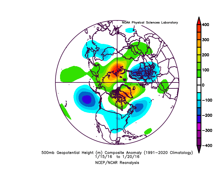

-
Jan Medium/Long Range Disco: Winter is coming
psuhoffman replied to stormtracker's topic in Mid Atlantic
GEPS went all in with the eps.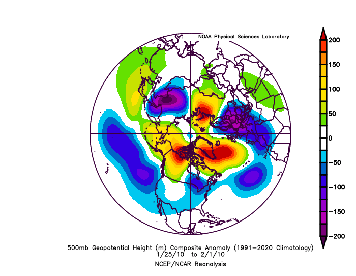
-
Jan Medium/Long Range Disco: Winter is coming
psuhoffman replied to stormtracker's topic in Mid Atlantic
The op gfs agrees with the eps pattern progression in the day 10-16


