

Nomz
-
Posts
705 -
Joined
-
Last visited
Content Type
Profiles
Blogs
Forums
American Weather
Media Demo
Store
Gallery
Everything posted by Nomz
-
January 24-26: Miracle or Mirage JV/Banter Thread!
Nomz replied to SnowenOutThere's topic in Mid Atlantic
I've never lived out in food desert-y areas, I guess. I stopped at a grocery store in DC to pick up hot chocolate supplies (college, so other food is hopefully taken care of) and it was completely stocked -
Means a lot to me, actually. If I see some semblance of support for this at 00z, I'll put a solid amount of faith in it.
-
January 24-26: Miracle or Mirage JV/Banter Thread!
Nomz replied to SnowenOutThere's topic in Mid Atlantic
Oh yeah, non-salted/sanded roads will be rough/impassable. Definitely want to get all your essentials by Saturday midday. -
January 24-26: Miracle or Mirage JV/Banter Thread!
Nomz replied to SnowenOutThere's topic in Mid Atlantic
NWS point forecast changed from the snow icon to the wintry mix icon for me
-
January 24-26: Miracle or Mirage JV/Banter Thread!
Nomz replied to SnowenOutThere's topic in Mid Atlantic
Gray slushy roads for the foreseeable future, yay! -
January 24-26: Miracle or Mirage JV/Banter Thread!
Nomz replied to SnowenOutThere's topic in Mid Atlantic
Open up your Apple weather app, lol -
Even though models have started to converge a little, I still can't shake the uncertainty of this forecast. If 700mb temps are off by even 1c, we have massively different outcomes, especially in the DC/South MD area. Literally two degrees C at 700mb stands between 5 and 12 inches. Tough forecast!
-
January 24-26: Miracle or Mirage JV/Banter Thread!
Nomz replied to SnowenOutThere's topic in Mid Atlantic
FWIW, I'm "dropping" my forecast for DC from 6-10+ to 6-10. Subtle but I hope that helps get the message across. -
January 24-26: Miracle or Mirage JV/Banter Thread!
Nomz replied to SnowenOutThere's topic in Mid Atlantic
Beyond the Soto trade a lot of y’all’s old pieces left for nothing or immediately turned into pumpkins (Strasburg, Corbin, Rendon). The Scherzer trade was good in principle but the prospects that came back busted big time. And the draft/IFA classes have been whiff after whiff. The new gm was actually our old director of scouting I believe, he should be able to improve drafting and IFAs a lot. -
January 24-26: Miracle or Mirage JV/Banter Thread!
Nomz replied to SnowenOutThere's topic in Mid Atlantic
What do you mean, we're getting 0% snow 100% sleet. I've seen this too many times. Trust me guys. -
January 24-26: Miracle or Mirage JV/Banter Thread!
Nomz replied to SnowenOutThere's topic in Mid Atlantic
I'm a Sox fan (see location). I think it's a pretty good haul for a guy that's probably not gonna be around for any possible winning window. Fein has a good chance of getting into the t100 very soon, and the others guys are really good high upside plays. Rosario and Fitz-Gerald (yes with a hyphen) had a ton of helium before they got injured this year, with Rosario likely out for all of 2027 because of TJ. Don't know about the last two guys. -
GFS sticks to its guns basically. Still not believing it.
-
January 24-26: Miracle or Mirage JV/Banter Thread!
Nomz replied to SnowenOutThere's topic in Mid Atlantic
... if we want to go there, an extra .5-1C since the 1990s probably is impacting this storm. Imagine if the 0C contour was where the 1C contour was and so on. When you're riding the knife-edge like we are, it matters.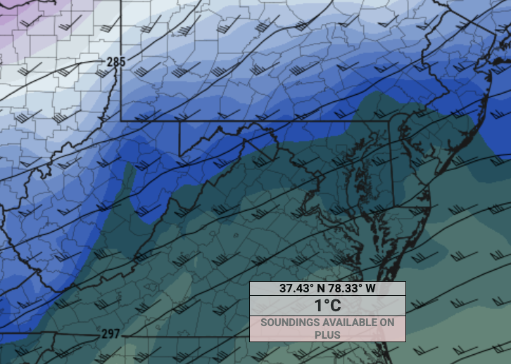
-
Probably a bad sign that I'm following this thread again...
-
ENSO patterns seem kinda useless at such short range. They give you an idea of what will happen months out, but all that matters in the moment is what's actually happening.
-
Sleet falls at around 3:1 right? Using Euro's QPF of 1.4 and conservatively guessing 1/2 of that to fall as snow, 1/2 as sleet; 0.7*10+.7*3 = 9.1 inches total accumulation. I'll take that as a baseline any day.
-
... it is sickening that PA/NYC/SNE are robbing us though
-
If you told me a week ago we'd get 8 inches in DC, I'd be happy. So I'm happy.
-
Apple weather is still showing 20-25 inches in DC… some people are going to be very disappointed.
-
Yeah I'd say there's a pretty solid consensus that, no matter where the sleet line sets up, it sets up about parallel to the Blue Ridge
-
Icon doesn’t really make sense to me with warmer 700mb temps due west of DC
-
From my experience the NAM overdoes low-level response which leads to a stronger LLJ, warmer temps and (for severe weather season) loopier hodographs.
-
As the LWX AFD mentioned, I'd use the 10:1 instead of the Kuchera for now. Even though most of the initial thump will have good ratios, towards the end, it'll get closer to the gray area, probably leading to somewhat wetter snow and smaller ratios.
-
That's a lottttt of freezing rain. I'd wager at least half of that is sleet instead.
-
Sounds like a hold. Assuming EPS and AI EPS are nominal, I think I'm gonna bump to 6-10"+ tomorrow morning.


