

Lucy Pull
-
Posts
111 -
Joined
-
Last visited
Content Type
Profiles
Blogs
Forums
American Weather
Media Demo
Store
Gallery
Everything posted by Lucy Pull
-
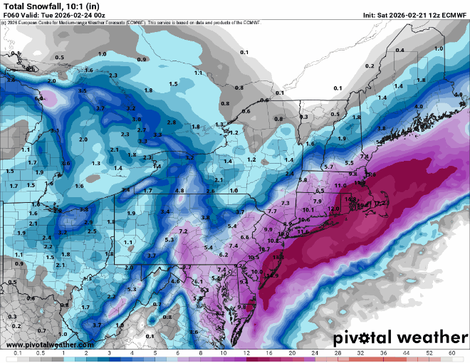
For reference…
-
EPS ensembles keeping a slightly further west cluster compared to 12z based off MSLP. Looks to reduce far eastern outliers as well. Don’t have precip output
-
This seemed like mostly noise to me. The precip field in general shifted northwest albeit slightly but the slug of moisture wasn’t as apparent towards PHI
-
Wait to see what EPS does that’ll be the teller. Operational can be quite blotchy with precip and max/min areas will jump between runs. looked a bit better at h5 based on the above GIF.
-
“Cory’s in NYC! Let’s HECS!” Feb. 22-24 Disco
Lucy Pull replied to TheSnowman's topic in New England
By hour 6 the difference in heights between the GFS and NAM is evident out in front. Heck they even look like they initialize substantially different. -
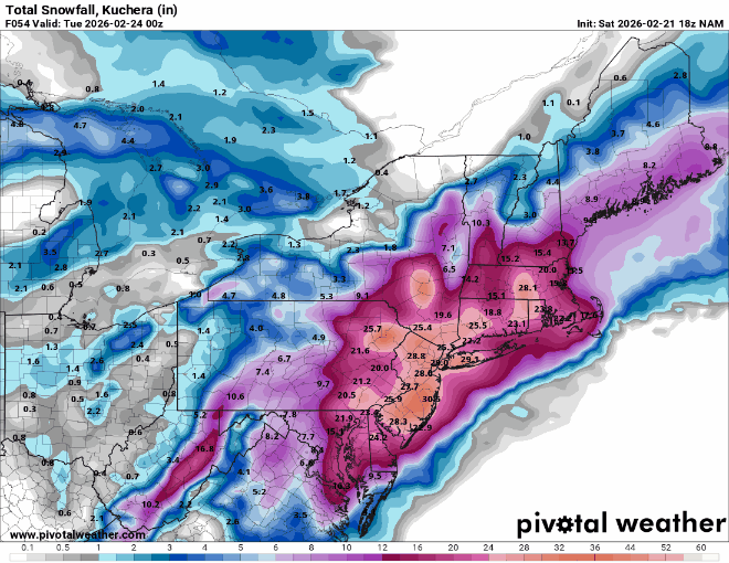
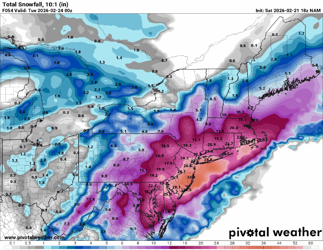
Posting for posterity’s sake. 18z NAM 10:1- Kuchera-
-
Buzzsaw…. Banding just sits and rots.
-
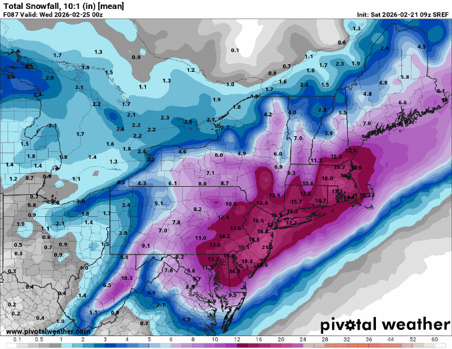
15z SREF did not disappoint. 9z to 15z trend
-
Clustered west. Those easterly lows probably dragging mean down quite a bit.
-
6z euro operational looked to be on the eastern envelope of its ensemble. Do you have ensemble mean by chance?
-
Was it winter storm “Juno” that did this last second? NWS had widespread 24-36 forecasts in and around NYC 2 days before I believe. If I recall the EURO and its ensemble was amped and GFS was progressive and east.
-
Down to interpretation mostly. Always going to have a zonked run or two…ahem NAM that puts the back thought of 30” into your head. If you look at this from the perspective of 24 hours ago it’s a completely different outlook. In other news 6z Euro and EPS look better. Some EPS members that definitely get the job done for the sub forum. Minuscule differences at h5 causing quite erratic surface depictions.
-
“Cory’s in NYC! Let’s HECS!” Feb. 22-24 Disco
Lucy Pull replied to TheSnowman's topic in New England
Doesn’t look like the NAM cares about that increased confluence early. Looks like the other changes will make up for it…. -
Agree, geographic area and sporadic maximum snow areas across a large portion of the country. Wondering what NESIS will come in at.
-
In saying this though….it does increase the floor if the coastal were to head further east.
-
Less IVT. Unless this backs west like GFS there will most likely be a screw zone between coastal and IVT.
-
GEFS precip mean increased for 18z. Operational still on the northwestern edge of ensemble but actually a few members even more amped than operational this run.
-
E PA/NJ/DE Winter 2025-26 Obs/Discussion
Lucy Pull replied to LVblizzard's topic in Philadelphia Region
GEFS a little more amplified. Operational was on the amped and western side of ensembles. A small cluster of members very close to operational. -
E PA/NJ/DE Winter 2025-26 Obs/Discussion
Lucy Pull replied to LVblizzard's topic in Philadelphia Region
Euro AI ensemble definitely more amplified 6z to 12z based off NYC forum. Pretty good westerly leaning cluster -
E PA/NJ/DE Winter 2025-26 Obs/Discussion
Lucy Pull replied to LVblizzard's topic in Philadelphia Region
Interested in what the Euro AI ensembles look like compared to 6z. -
E PA/NJ/DE Winter 2025-26 Obs/Discussion
Lucy Pull replied to LVblizzard's topic in Philadelphia Region
Don’t think you could draw it up much better. -
When I think of blocking in March I think of 2013. Obviously results will vary based off PNA.
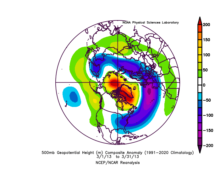
-
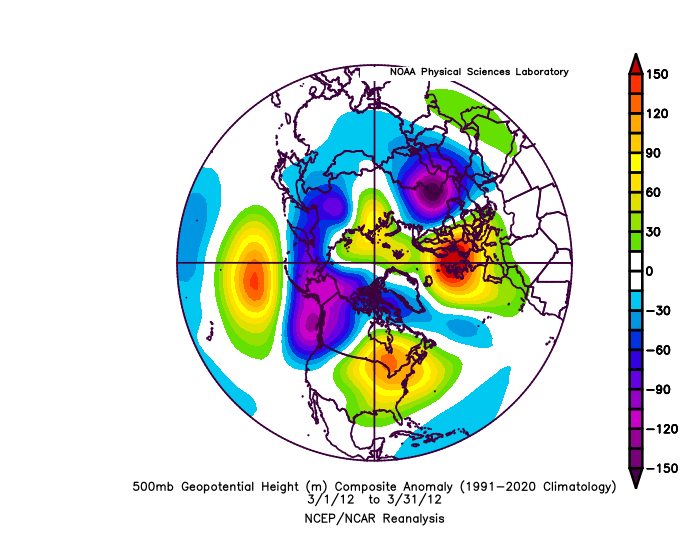
March 2012 for reference
-
You’ll be back sooner. It’s possible we don’t connect on any shortwaves but willing to bet “something” happens before then…even if it’s just modeled blues.
-
E PA/NJ/DE Winter 2025-26 Obs/Discussion
Lucy Pull replied to LVblizzard's topic in Philadelphia Region
AI models much more enthusiastic about Feb.5 potential. Resembling a SWFE with potential transfer. Something to keep an eye on at least.


