WeatherGeek2025
-
Posts
1,616 -
Joined
-
Last visited
Content Type
Profiles
Blogs
Forums
American Weather
Media Demo
Store
Gallery
Everything posted by WeatherGeek2025
-
Reggie?
-
I'm sticking with what the Euro AI shows but you already know that cause I say it a million times! Euro AI is the new king in town!
-
I hear you, I would love the euro on board too but it has been predicting terrible this year! We'll see what happens we should have consensus by tomorrow evening!
-

E PA/NJ/DE Winter 2025-26 Obs/Discussion
WeatherGeek2025 replied to LVblizzard's topic in Philadelphia Region
-
“Cory’s in NYC! Let’s HECS!” Feb. 22-24 Disco
WeatherGeek2025 replied to TheSnowman's topic in New England
-
is it better than Euro AI?
-
“Cory’s in NYC! Let’s HECS!” Feb. 22-24 Disco
WeatherGeek2025 replied to TheSnowman's topic in New England
-
-
yes i actually think it phased better. That east jog was like 10 miles tops maybe it was just a bit faster too. Ukmet next
-
it's a bit east for sure
-
looks good still not done
-
-
doesn't climb as much north precip wise to me it's noise that's a strong system
-
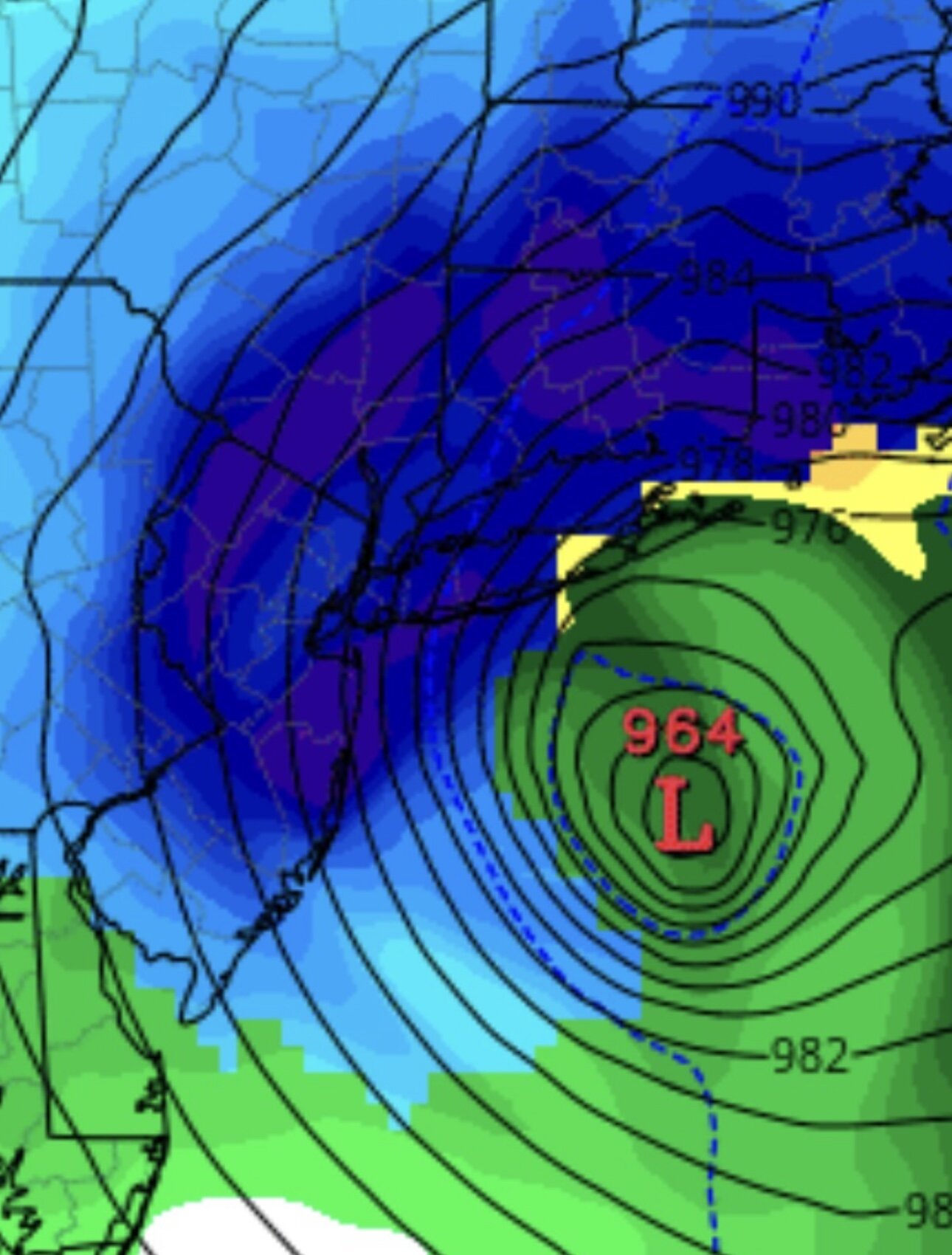
very similar stronger by 2 millibars and west by 7-8 miles
-
February 2026 OBS & Discussion
WeatherGeek2025 replied to Stormlover74's topic in New York City Metro
Radar is back just in time for the big blizzy lol -
i don't like it i don't know what to do now! guess we wait
-
February 2026 OBS & Discussion
WeatherGeek2025 replied to Stormlover74's topic in New York City Metro
I was just in Central Park and if there's a trace of snow that doesn't make sense it would be rain and it's not falling lol. Also there's a good two to 3 inches of slush at the park. By the way do you guys know the Central Park spread for the day? -
“Cory’s in NYC! Let’s HECS!” Feb. 22-24 Disco
WeatherGeek2025 replied to TheSnowman's topic in New England
-
“Cory’s in NYC! Let’s HECS!” Feb. 22-24 Disco
WeatherGeek2025 replied to TheSnowman's topic in New England
THIS, except AIGFS is almost as trashy as ICON! And Euro is not the Euro we used to see! It seems they switched the code with the AI guy! -
Feb 22nd/23rd "There's no way..." Storm Thread
WeatherGeek2025 replied to Maestrobjwa's topic in Mid Atlantic
If Euro AI doesn't go way west or at least 50-75 miles west i'd be a little pissed! -
Canadian 18z 84 hours
-
“Cory’s in NYC! Let’s HECS!” Feb. 22-24 Disco
WeatherGeek2025 replied to TheSnowman's topic in New England
-
-
that model sucks. I'm paying attention to Euro AI and GFS!


