WeatherGeek2025
-
Posts
1,682 -
Joined
-
Last visited
Content Type
Profiles
Blogs
Forums
American Weather
Media Demo
Store
Gallery
Everything posted by WeatherGeek2025
-
i got work tomorrow not sure how ill make it there though
-
it's coming
-
-
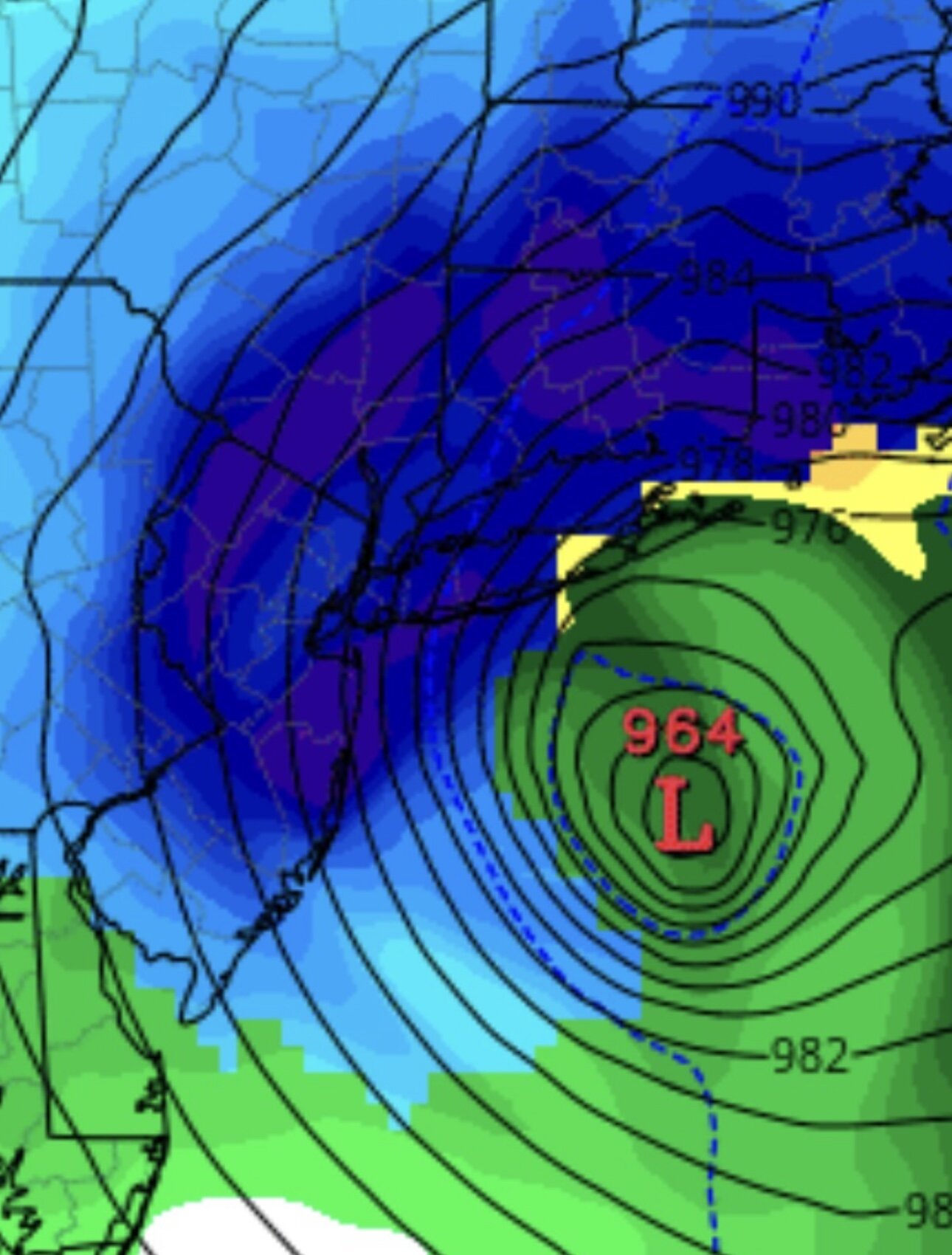
storm is only going to get colder aloft, no warm nose. low pressure well south of us deepening rapidly as the bombogenesis phenomenon takes over.
-
-
-

“Cory’s in NYC! Let’s HECS!” Feb. 22-24 Disco
WeatherGeek2025 replied to TheSnowman's topic in New England
stupid ai can't translate numbers sorry about that. -
“Cory’s in NYC! Let’s HECS!” Feb. 22-24 Disco
WeatherGeek2025 replied to TheSnowman's topic in New England
i have the original one but people complained it was too bright -
“Cory’s in NYC! Let’s HECS!” Feb. 22-24 Disco
WeatherGeek2025 replied to TheSnowman's topic in New England
my snowmap -
LfG!!!! wow this is exciting
-
i'm in and i feel conservative now
-
i agree i need a little something less bright next time maybe u can dm me with some suggestions
-
NYC 21 LGA 21 ISP 26 JFK 22 EWR 18
-
snowmap hope it verifies more i went a little conservative not sure why
-
Snowmap is out i think i went a little conservative here now that im looking at the latest models oh well!
-
tony stole it
-
did that already. Also i'm truly surprised tropicaltidbits even has icon as a model choice. it's literally the worst model, the only thing that it's useful for is 2m surface temps it's somewhat accurate
-
I agree this is like a hurricane CAT 2 with snow
-
okay sorry I was just asking Tony cause he's a better forecaster than you
-
tony u think my bet is a lock? i need 13.9 inches of snow for central park for the remainder of February?
-
just made a bet on gemini for central park to get 15+ inches for the month of february i think that's free money.
-
https://x.com/gemini/status/2025364857097228742?s=46 easy money i'm putting $1000 15 inches
-
https://x.com/cryptogeek101/status/2025355930049597947?s=46 poll on central park accumulations
-
mirrors 1978 blizzard
-
GFS is the new King!


