WeatherGeek2025
-
Posts
1,682 -
Joined
-
Last visited
Content Type
Profiles
Blogs
Forums
American Weather
Media Demo
Store
Gallery
Everything posted by WeatherGeek2025
-
what did i miss my friends? euro came west?
-
GFS 12z is a #HECS
-
can you or allsnow just do it
-
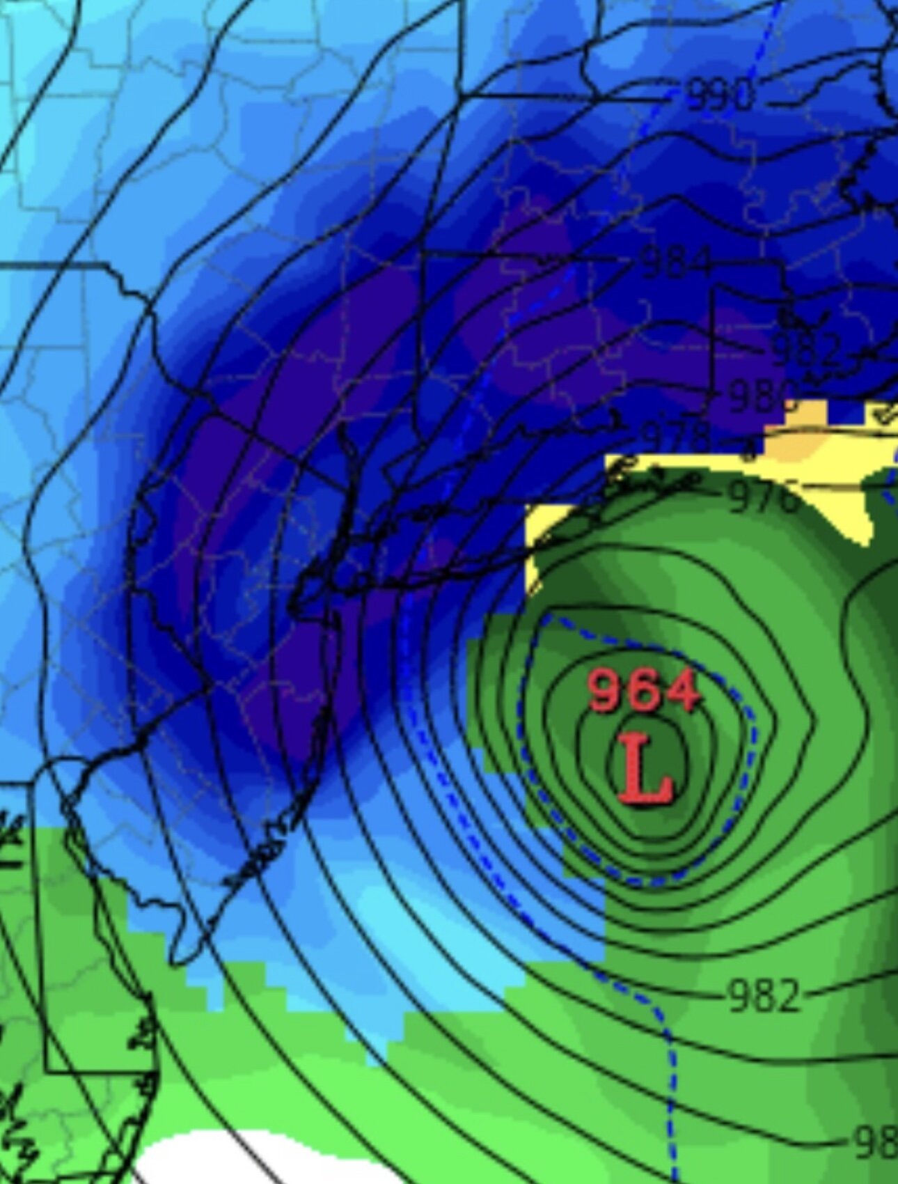
Basically a hurricane
-
you got Kuchera Tony? lol
-
Good morning New York City. Blizzard is on its way but today will be a beautiful day to run your errands before the storm hits. Currently 34 degrees with the beautiful sunrise coming up. It's going to be a relatively warm day today with a high of 47 light and variable winds. Tonight the temperature drops to around 34 degrees as the clouds roll in by sunrise. Sunday: we have a blizzard warning here with expected snow during the day around 2-4 inches during the day. Sunday night blizzard conditions, dangerous wind up to 70 mph in highest gusts, possible thundersnow and heavy wet snow with a low of 26 degrees with 10-14 inches of snow. Monday: Blizzard conditions in the morning with heavy snow, tapering down to light snow showers by early afternoon and ending west to east by 3pm high of 34 very windy. 3-6 inches of additional snow. Total storm snow accumulations of 15 to 24 inches possible. Monday Night: Cold and windy night low of 22
-
we pretty much have consensus here, i think it's between nam euro and gfs at this point it's safe to say 10-20 inches are a lock NYC and east, with blizzard winds blowing and drifting definitely a concern! What happens west of Bergen county is still in question and will be ironed out today!
-
never give up good morning, i see some of my posts were deleted. I think this is just a sign that the westerly trend is over and the models will correct back to around where the GFS is. Remember all models trended towards the GFS yesterday 80% models had nothing. We will see by tomorrow but I honestly still think the euro is the most overrated model there is, icon may be better at this point! We'll see but to me it just looks like the west trend is over and they'll just wobble back and forth between GFS and maybe Euro AI solution!
-
noise
-
lost my dad during covid they put him on a ventilator forget it he was gone didn't even get to say bye to him, but yes like John said spend as much time as you can with them, it's crazy how much you miss them and first few months you can't stop crying after that it gets a bit easier but you're always like man i just wanna hug them at least once more. sorry for getting emotional. stay strong John
-
sorry about ur mom John
-
do you have the numbers from 18z? sorry to bother u Sacrus
-
it's like a hurricane cat 2 but a blizzard
-
PBP either allsnow or yanks fan for old sake since earth light ain't showing up
-
changing a diaper
-
he was posting earlier ironically lol
-
you're right... all snow? PBP?
-
i was reading some of his stuff from 2010 lol
-
super typhoon posts in new england sometimes, no?
-
welcome back man
-
Long Island and Jersey shores or just inland are prime spots for thundersnow for this storm in my opinion!
-
you're literally in the most perfect spot for this storm. I like Plum Island as the Jackpot for this storm! Why because there'll be ocean enhanced snow with those gusty winds!
-
that was a different setup, it was heavy rain to heavy snow. completely different setup. we're not raining guys come on here
-
there could be some white rain south and east of let's say Bergen county for a two hour period but it won't be the heavy precip so it won't really matter that much. Honestly i think we snow the whole time
-
no rain at all maybe south jersey to begin, it'll snow from the start and wet bulb


