

WintryMixmaster
-
Posts
113 -
Joined
-
Last visited
Content Type
Profiles
Blogs
Forums
American Weather
Media Demo
Store
Gallery
Everything posted by WintryMixmaster
-
Got about a quarter inch of snow this AM, nice to break the winter shutout!
- 618 replies
-
- 4
-

-
- observations
- obs thread
- (and 1 more)
-
What's your elevation? I'm on that little peninsula bounded by Sinking Creek. Pellissippi, and the TN river but at 980 feet elevation. I remember during my lurking years that my observations at my apartment in Hardin Valley were similar to yours with usually just a tick less snow, so I assumed you were maybe on a hill or in a slightly colder spot in that area
-
Sounds pretty similar to what I have. Definitely not purely mist now, I definitely saw a few things bounce, and a few snowflake-looking things that are blowing in the wind. Icicles starting to form on the siding of the house
- 618 replies
-
- 2
-
-
- observations
- obs thread
- (and 1 more)
-
I need to move to you guys' part of town because I still just mist here. Below freezing now though, standing water is starting to freeze up
- 618 replies
-
- 1
-
-
- observations
- obs thread
- (and 1 more)
-
At first I thought it was snow based on how it moved in the air, but it's actually a very fine mist right around 32 degrees at my house
-
January 2026 Short/Medium Range Thread
WintryMixmaster replied to John1122's topic in Tennessee Valley
Sorry, I should've been more clear with that post. I was trying to say that this winter (at least for Knoxville) has been as bad as it can get (I mean, you can't do worse than 0.0" with multiple winter storm setup teases) but that there's plenty of time for it to change and it just takes one storm to turn a winter from awful to amazing. I wasn't trying to imply that I think it will or won't get better, just venting frustration with how things have gone to this point. On a side note, one thing that always stood out to me about this forum from my time as a lurker is that while posters get understandably frustrated when we whiff on storms or have a bad winter, there's an appreciation for the snow that we do get however minor in amount or duration and a genuine love of meteorology. Growing up reading the accuweather forums for the NYC metro area, it was crazy how many posters acted like a whiff on a snowstorm or a mild winter meant that it would never snow again. Even if this winter does turn out to be a dud, there's always next winter and the one after that. -
January 2026 Short/Medium Range Thread
WintryMixmaster replied to John1122's topic in Tennessee Valley
This really has been the worst possible winter in East Tennessee... cold/dry with high heating bills, false hope storms just barely missing our area despite a good pattern on paper, and drought conditions. My only hope is that it only takes one storm to take a winter from 0/10 to 10/10 when we live somewhere with such a low seasonal average. Winter 2023-2024 sucked outside of 1 week, but that one week was probably the most epic week of winter I'll ever experience in Knoxville -
Yeah NWS Morristown doesn't sound confident either, just a brief mention of freezing drizzle/flurries behind the front in their forecast discussion. I just want something to measure haha, I give it a 30% chance in my backyard on getting anything more than flurries. Maybe higher towards Blount/Sevier counties
- 618 replies
-
- 1
-
-
- observations
- obs thread
- (and 1 more)
-
No snow accumulation from this storm in my backyard, a light dusting of sleet, a thin (0.1" or so) coating of ice on elevated surfaces, and now a nice cold rain. If we weren't going to get snow, I'm thankful Knoxville at least dodged any crippling ice. The fact that surface temps verified a couple degrees warm really saved us from having ice on the roads. A few models look like they have some backend snow for the foothills tonight... not much, but better than more ice or rain. Nam 3k, HRW WRF-ARW, RDPS all have a dusting to an inch or so in the central and northern parts of the valley. Would be a nice consolation prize to get on the board for snow accumulations on the winter and have some white on the ground heading into this freezing cold week
- 618 replies
-
- 1
-

-
- observations
- obs thread
- (and 1 more)
-
The good old days of Monday-Tuesday haha. I remember looking at that and thinking "wow that's a sharp gradient just south of TN, we could get nothing if this tracks just a bit north" and then...
- 618 replies
-
- 1
-
-
- observations
- obs thread
- (and 1 more)
-
Moderate sleet coming down now. I'm pretty sure everyone north, east, west, and even southwest of me as reported at least a little snow, but I'm apparently in some kind of warm bubble. Down to 31.5 degrees
- 618 replies
-
- 1
-
-
- observations
- obs thread
- (and 1 more)
-
What part of west Knoxville are you in? I'm near Northshore town center-ish
-
Light sleet shower now with that heavier echo SW of downtown Knoxville
- 618 replies
-
- 1
-
-
- observations
- obs thread
- (and 1 more)
-
32.5 degrees, 45% humidity and cloudy here. Definitely verifying a bit warmer than expected
-
Did they recently update? I saw they gave us a WWA though, down from Ice Storm warning. Hopefully that means less ice than expected. I feel like yesterday the short range models had us almost immediately going over to sleet, now it looks like our area will get at least some light snow tomorrow afternoon. Maybe get on the board for the season on accumulations
-
Some major differences there... I imagine there's a fine line between sleet vs freezing rain at 31 degrees vs plain rain at 32 degrees. A couple degrees in the mid-lower levels of the atmosphere could make this a lot better or a lot worse for a lot of people
-
On a related note, it also sucks to be without water. My pipes froze during last winter's MLK day weekend cold snap because I mistakenly assumed my house was better insulated than it was... luckily no damage when they thawed, but it definitely reminded me how easy it is to take for granted something as simple as being able to go to the bathroom or wash your hands by turning a knob. Definitely going to drip the taps this week!
-
January 2026 Short/Medium Range Thread
WintryMixmaster replied to John1122's topic in Tennessee Valley
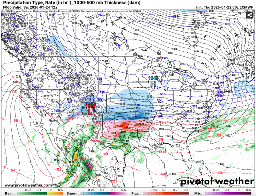
Oh yeah I don't buy it for a second lol but the Euro did have a similar setup, just looked like maybe a little too much separation to pull off the phase (wouldn't that be a slap in the face after this weekend's storm?). I think the 00z Euro last night had it too -
January 2026 Short/Medium Range Thread
WintryMixmaster replied to John1122's topic in Tennessee Valley
GFS: "Sorry I got your hopes up this weekend" Also the GFS: "HEY LOOK OVER HERE!"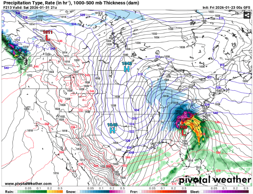
-
HRW WRF-ARW look to have light snow over Knox County from hours 41-44, but only registers as 0.1 inch on pivotal's 10:1 total snowfall map. I guess maybe that's sleet being interpreted as snow?
-
Obviously a different setup, but if I remember correctly, the January 2025 storm forecast was pretty much set in stone and the phase ended up being a bit sloppy/late, giving the southern valley/N GA/N AL a surprise snow (and leading to a small bust for the northern valley). So I guess it isn't impossible that with so many pieces of energy coming together, this could surprise us despite the models seemingly converging on the amped solution. I feel like my ideal scenario would be the first wave coming in weaker and a few counties south giving us a nice front end snow/sleet, and the second wave coming in as temperatures go above freezing and giving us plain rain with no ZR in between.
-
Having the subtropical jet throwing moisture straight at a 1045 HP in southern Wisconsin and ending up with 0 inches of snow in the valley is like the weather equivalent of throwing a pick six on 1st and goal from the 1... we're just sitting there watching the warm nose run it back for a touchdown. The HP actually retreating northwest between hours 60 and 66 is a nice touch, like the QB chasing down the warm nose and giving up, lol
-
I really want to know what they were thinking with that snow map... I don't like to question people smarter than me, and the meteorologists there have forgotten more about weather than I'll ever know, but like, did someone fall into a coma 24 hours ago, wake up, and then hit "send" on that map without checking any recent models?
-
Gotta love single digit temps with a bare ground after a nice cold rain. On the plus side, the rug pull by the models happening over the course of a single model suite was better than watching it slowly slip away. And there's still plenty of winter to go


