WintryMixmaster
-
Posts
114 -
Joined
-
Last visited
Content Type
Profiles
Blogs
Forums
American Weather
Media Demo
Store
Gallery
Everything posted by WintryMixmaster
-
Spring 2026 Pattern Discussion Thread
WintryMixmaster replied to Carvers Gap's topic in Tennessee Valley
I did end up with 0.35" according to my new rain gauge, but there was some significant flooding closer to downtown Knoxville. Very localized rain today apparently, it was weird seeing the Flash Flood Warning and seeing dry ground outside haha- 309 replies
-
- 1
-

-
- severe
- mountain snow
- (and 1 more)
-
I liked the picture of the 1980 "Miracle on Ice" with "GFS" photoshopped over "USA" on the jerseys of the celebrating American players. That's what that storm seemed like to me, GFS got its once a decade upset over the Euro haha And yeah we also had on and off snow flurries for almost 24 hours, which is kind of crazy. Obviously no accumulation besides a trace on some of the roofs, but it was a nice surprise
-
Not really accumulating but some big fluffy flakes have been blowing in the wind, going back and forth between flurries and steady light snow. Looks nice and wintry, hopefully not the last ones of the season but they very well might be
-
A few stray flurries here tonight
-
I'll take a shot, I've been following along with this storm since I have a lot of friends and family in NJ/PA (plus sometimes I like to pretend that 12 year old me is still in my childhood backyard in NJ measuring snow) NYC: 12.9 LGA: 13.0 ISP: 15.8 JFK: 13.9 EWR: 13.2 Bonus prediction for my current backyard, after careful consideration of all the models and trends Knoxville: 0.0
-
I love that it's always the happy hour GFS runs that somehow always dole out the most hope... I swear some government programmer put an Easter egg in the code to tweak the 18z GFS solutions towards colder/snowier just for us snow weenies lol
-
Oh yeah that's right, I remember it snowed all the way up into the northeast as the storm headed that way - though New Jersey didn't get as much as we did
-
My biggest snow here was in January 2024... my second biggest was March 2022. Do you remember the setup? I think it was a bowling ball ULL that dropped down from the north, but I remember it being very mild the day before, snowing extremely heavily overnight and into the morning hours, and ending with 6.5 inches. Quickly melted away in the afternoon sun and the next day as it warmed up again, but an exciting storm of a magnitude I never thought I'd experience in Knoxville again (until January 2024 came around that is). But I definitely never write off March after that, even if the odds are low
-
I hope you're right and these last 2 winters weren't just an anomaly. Though I think my favorite winter here was 2023-2024 - a big storm and snow on the ground for a week, but mild otherwise. Cold and dry is my least favorite kind of winter - though I know some others will disagree, since the cold at least makes it feel more like winter even without snow
-
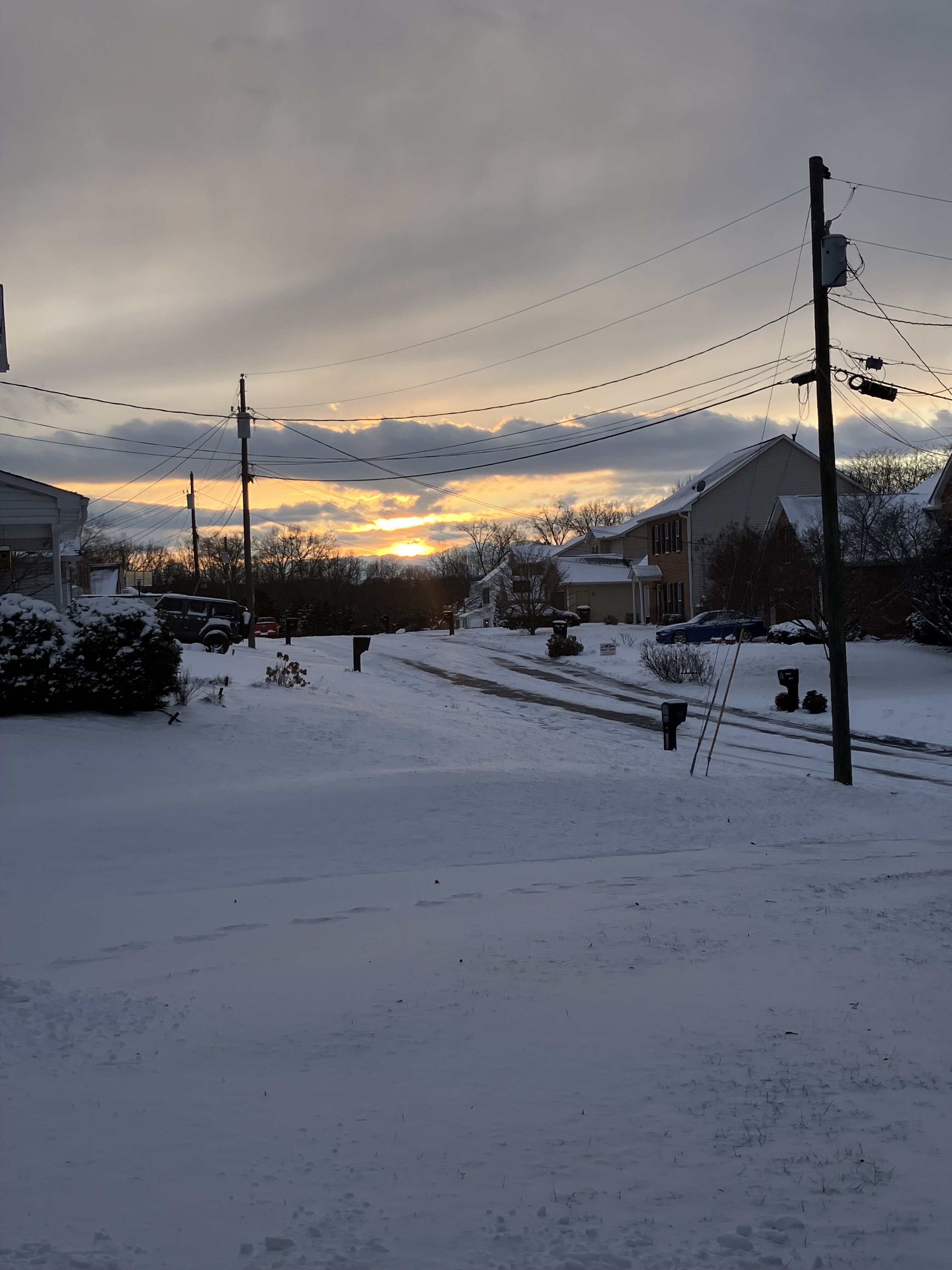
About a quarter inch of snow at my house, I'm curious if there's larger totals up by Halls because it seemed like they were under a steadier band of snow for longer before it weakened as it moved south
-
A nice dusting on the grass and wet roads would be ideal for my drive to work tomorrow, especially since I'm sure the rain washed away the salt they put down for the last storm
-
Maybe that band of more steady snow that's currently in N Knox County/S Anderson County can get down here before dissipating
-
Very light snow has been falling here for about 30-45 minutes... there's a thin dusting (<0.1") on some of the colder elevated surfaces. Radar has had no reflections over my house though (snow hole along I-140, just south of the "K" in Knoxville on the map)
-
Some light rain/snow mix is falling at my place now too
-
33.4 and on and off drizzle, haven't seen any snow yet but its hard to tell with how little precip is falling
-
My first thought when I saw the snow hole was that maybe the high res models were overdoing some terrain effect... I didn't realize you were on the Virginia side of the Cumberland Gap, maybe the model just creates some super downslope effect in that area to try and more accurately match the erroneous snowfall totals in that area? I didn't realize the models got fed previous local snowfall data for future forecasts but it makes sense that if the models consistently busted high with respect to the erroneous data, someone would try and tweak the geography or something in the model to make it "more" (though in this case less lol) accurate for that location
-
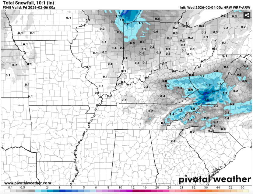
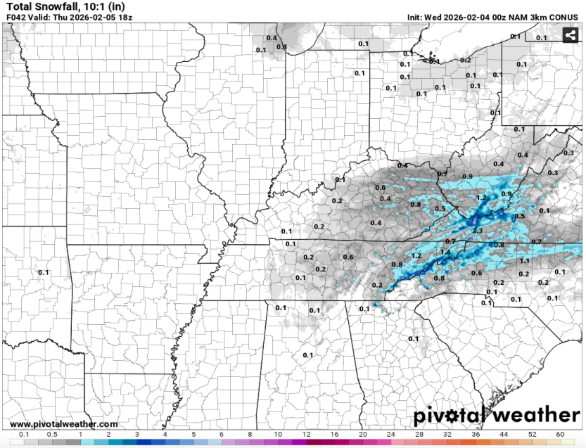
It's kind of interesting how some of the models show the snow hole there and some don't. RDPS and NAM don't have it, but the NAM 3k does and the HRW literally has snow on all sides of Lee County but stops right around the county lines lol. Are certain models being fed the bad data while others don't have the resolution to pick up on it?
-
Short range models have been consistently showing this dusting of snow tomorrow evening. I'll take any accumulation I can get if the ground temps cool off enough and we get enough moisture from the lee side low. Nickels and dimes still add up over the course of a winter
-
That looks almost dead on for my backyard (light-medium blue shading in SW Knox Co)... 0.2" dusting after the ice storm and 3.8" from last weekend.
-
Jan 30th-February 1st 2026 Arctic Blast/ULL Snow OBS Thread.
WintryMixmaster replied to John1122's topic in Tennessee Valley
Final total of 3.8" actually matched exactly with last January's storm... both times, the Knoxville area did okay but last year, Chattanooga was the jackpot zone and this time, NE TN was
-
Jan 30th-February 1st 2026 Arctic Blast/ULL Snow OBS Thread.
WintryMixmaster replied to John1122's topic in Tennessee Valley
I'm too far west of the Cedar Bluff band, too far east for the Farragut band. Looks like they're slowly moving east though. Somewhat off topic but I'll never forget my first snowstorm here in early January 2022... I read the forum all night, watched the valley hold onto the warm air as the cold from the Plateau slowly worked its way down, watched the rain change to sleet and then snow at like 1:30 AM, and then woke up to a surprise 1.8 inch of snow. Meanwhile outside of Hardin Valley (where I lived at the time), there was little if any accumulation, it's like the storm was specifically for me. After that I don't complain about having slightly lower totals than the people around me, I used up my good luck that winter lol -
Jan 30th-February 1st 2026 Arctic Blast/ULL Snow OBS Thread.
WintryMixmaster replied to John1122's topic in Tennessee Valley
The sun is fighting through the thin clouds here... helping a little bit with the roads, but making my driveway a lot slushier to shovel -
Jan 30th-February 1st 2026 Arctic Blast/ULL Snow OBS Thread.
WintryMixmaster replied to John1122's topic in Tennessee Valley
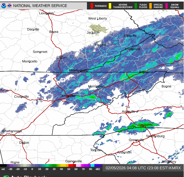
From the weather channel's radar, you can see the thin band of heavier snow that set up shop N-S through Cedar Bluff and briefly jogged west 1-2 miles and gave me that period of heavier snow (that dot it actually about 1.5 miles due north of my house)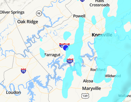
-
Jan 30th-February 1st 2026 Arctic Blast/ULL Snow OBS Thread.
WintryMixmaster replied to John1122's topic in Tennessee Valley
Back to baby snowflakes but I think that 10-15 minute period added 0.1" to my total haha -
Jan 30th-February 1st 2026 Arctic Blast/ULL Snow OBS Thread.
WintryMixmaster replied to John1122's topic in Tennessee Valley
I was thinking maybe it was just the flake size getting bigger because we were warming up but no, visibility has definitely dropped. I think the models had it cutting off for our area around now and only continuing in the foothills, but I wonder with the air saturated/NW flow and temperatures dropping whether we can wring out a bit more moisture this afternoon/evening. At least enough for more mood flakes